Armuthsbach
| Armuthsbach | ||
|
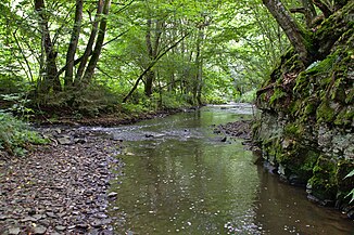
Armuthsbach near Daubiansmühle, on the left the Buchholzbach flows. |
||
| Data | ||
| Water code | DE : 271856 | |
| location | Germany | |
| River system | Rhine | |
| Drain over | Ahr → Rhine → North Sea | |
| source | south of Tondorf 50 ° 27 ′ 34 ″ N , 6 ° 42 ′ 4 ″ E |
|
| Source height | approx. 531 m above sea level NHN | |
| muzzle | west of Schuld in the Ahr Coordinates: 50 ° 26 ′ 49 " N , 6 ° 52 ′ 32" E 50 ° 26 ′ 49 " N , 6 ° 52 ′ 32" E |
|
| Mouth height | approx. 241 m above sea level NHN | |
| Height difference | approx. 290 m | |
| Bottom slope | approx. 16 ‰ | |
| length | 18.4 km | |
| Catchment area | 60.526 km² | |
|
Gorse blossom in the Armuthsbachtal between Pitscheid and Wennefeldermühle |
||
The Armuthsbach (also Armutsbach ) is an 18.4 km long left tributary of the Ahr in North Rhine-Westphalia and Rhineland-Palatinate .
geography
course
The Armuthsbach rises about 1.5 km southwest of Tondorf at an altitude of 531 m above sea level. NHN . The source is in the area of Blankenheim . The Armuthsbach flows through the village of Rohr, flowing mainly in an easterly direction . Below the village, the stream reaches the state border with Rhineland-Palatinate . In the further course to the mouth there are no other villages on the river. About 400 m north of the brook is Hümmel , about 900 m south of Wershofen . About 800 m west of Schuld the Armuthsbach flows out at 241 m above sea level. NHN on the left into the Ahr .
The Armuthsbach flows through the North Rhine-Westphalian nature reserve Armuthsbach and tributaries .
Catchment area and tributaries
The 60.526 km² catchment area is drained to the North Sea via the Ahr and Rhine . With a height difference of 290 m, the mean bed slope is 15.5 ‰. The most important tributary of the Armuthsbach is the 7.7 km long Buchholzbach .
|
Stat. in km |
Surname | GKZ | location | Length in km |
EZG in km² |
Mouth height in m above sea level NHN |
|---|---|---|---|---|---|---|
| 16,588 | Derchbach | 271856 112 | Left | 1.118 | 1,899 | 472 |
| 16,339 | Mühlenbach | 271856 114 | Left | 1.557 | ? | 467 |
| 14.747 | Werthsbach | 271856 116 | right | 2.544 | 1,899 | 441 |
| 13,490 | Weierbach | 271856 118 | right | 1.915 | ? | 419 |
| 12.624 | NN | 271856 1192 | right | 0.976 | ? | 408 |
| 12,499 | Wellbach | 271856 12 | Left | 3.111 | 2.133 | 407 |
| 11,041 | Borner Bach | 271856 132 | Left | 2.515 | 1.564 | 389 |
| 9.238 | Bröhlinger Bach, also: Stoffelsbach | 271856 14 | Left | 3.242 | 3,983 | 366 |
| 8.013 | Dog soaps | 271856 152 | Left | 1.07 | 0.829 | 350 |
| 5.854 | Mill soaps | 271856 16 | Left | 1,590 | 1.016 | 323 |
| 4,820 | Human soaps | 271856 172 | right | 1.241 | 1,226 | 309 |
| 2.796 | Brommersbach | 271856 18 | Left | 6.533 | 8,829 | 277 |
| 1.929 | Buchholzbach | 271856 2 | Left | 7,699 | 17.676 | 265 |
| 1.505 | Waldbach, also: Rupperather Bach | 271856 92 | Left | 1.304 | 1,365 | 260 |
| 0.030 | Homemade soaps | 271856 96 | Left | 1.127 | 0.869 | 243 |
Web links
- Catchment area and course of the Armuthsbach in ELWAS
- Nature reserve "Armuthsbach und Nebenbächer" in the specialist information system of the State Office for Nature, Environment and Consumer Protection in North Rhine-Westphalia
- Armuthsbach in the AW-wiki
Individual evidence
- ↑ a b Measurement based on the German basemap 1: 5000
- ↑ Map service of the landscape information system of the Rhineland-Palatinate nature conservation administration (LANIS map) ( notes )
- ↑ a b c Water directory of the State Office for Nature, Environment and Consumer Protection NRW 2010 (XLS; 4.67 MB) ( Notes )
- ↑ GeoExplorer of the Rhineland-Palatinate Water Management Authority ( information )
- ↑ Specialized information system ELWAS, Ministry for Climate Protection, Environment, Agriculture, Nature and Consumer Protection NRW ( information )

