Rohr (Blankenheim)
|
pipe
Municipality Blankenheim
Coordinates: 50 ° 27 ′ 9 ″ N , 6 ° 44 ′ 0 ″ E
|
||
|---|---|---|
| Height : | 445 m above sea level NHN | |
| Area : | 8.58 km² | |
| Residents : | 420 | |
| Population density : | 49 inhabitants / km² | |
| Incorporation : | 1st July 1969 | |
| Postal code : | 53945 | |
| Area code : | 02440 | |
|
Location of Rohr in North Rhine-Westphalia |
||
|
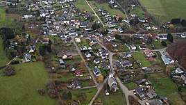
Rohr (Blankenheim), aerial photo (2015)
|
||
Rohr is a district of the municipality of Blankenheim in the Euskirchen district in North Rhine-Westphalia .
location
The place is northeast of Blankenheim. The district road 79 leads through the village and the Armuthsbach and the Wehrtsbach flow . In the east of Rohr, the Lindweiler district is directly connected .
history
In Frankish times, Rohr was a royal court . The place is mentioned for the first time in 893. In the middle of the village there is a castle tower and the former manor house . Castle walls and a castle cellar still exist today. To the west of the castle is the secular chapel of St. Antonius Eremita .
During the French period, Rohr belonged to the canton of Blankenheim.
The listed church of St. Wendelin was built in 1864 in place of an older building.
On July 1, 1969, Rohr was incorporated into Blankenheim.
Others
Web links
Individual evidence
- ↑ Martin Bünermann: The communities of the first reorganization program in North Rhine-Westphalia . Deutscher Gemeindeverlag, Cologne 1970, p. 100 .


