
Arloff
|
Arloff
City of Bad Münstereifel
Coordinates: 50 ° 35 ′ 40 ″ N , 6 ° 47 ′ 30 ″ E
|
||
|---|---|---|
| Height : | 221 m above sea level NHN | |
| Area : | 9.98 km² | |
| Residents : | 1117 (December 31, 2018) | |
| Population density : | 112 inhabitants / km² | |
| Incorporation : | 1st July 1969 | |
| Postal code : | 53902 | |
| Area code : | 02253 | |
Location of Arloff in Bad Münstereifel |
||
 Arloff Castle in the Erft Valley
|
||

Arloff is a district of Bad Münstereifel in the district of Euskirchen , North Rhine-Westphalia .
location
Arloff is located in the Voreifel between Euskirchen and the old town of Bad Münstereifel on the border of Zülpicher Börde and Eifel .
The Erft flows through the village . The Erft and the state road 194 that runs along the Erft are crossed by local roads that run along the edge of the Eifel. The buildings of Arloff and Kirspenich to the north of it in the wide Erft valley merge into one another.
history
The upper Erft valley was already settled in Roman times. East of Arloff, the Roman Eifel aqueduct carried its spring water to Cologne . One of the oldest village settlements in this region is the town of Arloff, which is first mentioned in 893. The voucher can be found in the Prüm Urbar , in which all rights and income from the numerous possessions of the Prüm Abbey are recorded in the past . In 1993, Arloff celebrated its 1100th anniversary with some of the neighboring towns that were mentioned just as early. Apparently, Arloff had been a court of law since medieval times. A document in the State Archive of North Rhine-Westphalia shows a complaint from Kurköln , in which the Archbishop of Cologne, Ernst von Bayern, sued Jülich officials in 1596 against attacks. The Dingstuhl Arloff is mentioned in this document .
Origin of name
The place name changed in the documents and sources from Arnefa via Arnepa and Arnopa, as well as Arlefa, Arlafa, Arlapa, Arfia to today's Arloff. The roots of the name Arnefa are believed to go back to the Celtic period and, according to “Mürkens”, mean something like stream or water. The same word formation applies to the Erft, whose name can be found in the place name.
Administrative affiliation
Arloff and Kirspenich belonged to the Hardt office in the Electorate of Cologne until the end of the 18th century . Under French administration (1798 to 1814), Arloff belonged to the Mairie Münstereifel in the canton of Rheinbach , Arrondissement Bonn , Rhine-Mosel-Département . After the Rhineland was assigned to the Kingdom of Prussia at the Congress of Vienna (1815), Arloff and Kirspenich formed a municipality that from 1816 onwards belonged to the Münstereifel mayor (renamed Amt Münstereifel in 1927) in the Rheinbach district and the administrative district of Cologne .
On July 1, 1969, Arloff was incorporated into Bad Münstereifel. Parts of the community were reclassified to Euskirchen .
Historic buildings
Arloff Castle

The group of buildings at Arloff Castle , which today looks rather inconspicuous on the Erft, is one of the typologically important castles in the Rhineland . Because a purpose-oriented defense structure from the early Gothic period is rarely found in such clarity. The former moated castle was first mentioned in a document in 1278. It was never permanently owned by a single family and in earlier times was subject to changing authorities until the territorial domains were consolidated . In the Middle Ages it was of strategic importance because of its location, as it was on the border between the Electorate of Cologne and the County of Jülich .
Old Mill


The cultural landscape of the Voreifel has been shaped by the Erft, which rises in the Ahr Mountains, since earlier times . The Erft, which flows through the Euskirchener Land due to its gradient from the height of this low mountain range, was used in many ways. The Erft, which used to be rich in fish, was primarily used to operate mills and hammer mills . The river's hydropower was coveted and feared, and numerous water levels attached to Arloff's houses as flood markings illustrate the violence that can sometimes occur in the Erft. The power of the river was also able to operate 24 mills in the Euskirchen area alone, one of these water mills was the Arloff castle mill.
Although the Arloff mill belonged to the feudal estates of the lord of the castle, in contrast to the castle it was always and indisputably subject to the "Jülichern". Leases for the Arloffer Burgmühle go back to the beginning of the 18th century and name members of a family "Dahmen" as the tenant. Up until the end of the 19th century, he exercised his rights and obligations as a tenant of a “compulsory mill” and processed the grain of the farmers of Arloff and that of the other farmers of the mill ban . In the case of a “manorial” “ compulsory mill ”, all land tenants were forced to have their grain milled in this mill. The miller kept part of the grist for his work and costs. The mill was leased by the lord of the castle with the associated land, first with 11, later around 1928 with 14.5 acres of land. An existing document from 1651 lists the lease conditions at that time. It shows the negotiated details of the contractual partners, the lord of the castle Werner Dietrich von Friemersdorf and the Burgmüller. The castle mill, which had been leased to the Dahmen family for several generations, was acquired by the family in the mid-19th century.
Hubertus Chapel and Vicarie
_(1).jpg)

The construction of the small house of God coincides with the time when two plague epidemics struck the region. After the population had recovered from the first wave of plague in 1348, the nearby “Münstereifel ” was almost depopulated in 1451 by the “ Black Death ”. Probably a reason for the survivors to build a house of worship to thank them for being spared. The Hubertus Chapel was built in 1466 by the master builder "Rheinhard Schröder". During restoration work in 1955, frescos from the time it was built were discovered and exposed. The old vicariate buildings, made of natural stone, like the small chapel, have also been restored . The chapel consecrated to St. Hubertus and Antonius celebrates its annual feast day on November 4th.
Eifeldorf and district

Between Arloff and its neighboring town of Iversheim in the direction of Bad Münstereifel , whose name refers to the Franconian era, you can visit an excavated, partially reconstructed Roman lime kiln .
Apart from these Roman traces, today's district of Arloff is older than the core town of Bad Münstereifel, which was able to grow significantly through its recognition as a health resort and later through the incorporation of municipalities as part of a municipal reorganization .
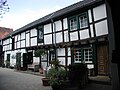
Arloff's “history” is reflected in its old building fabric. In addition to the outstanding historical monuments dealt with above, there are many old stone or half-timbered houses in the village . The mostly restored buildings, whose construction with their closed inner courtyards corresponds to Franconian four-sided courtyards , are in good condition.
patio

Franconian construction

"Hundertwasser" in Arloff

Old train station


today
The local children attend the “Municipal Catholic Primary School ” and those who are not yet of school age can use the kindergarten . A supermarket offers daily necessities, and there is also a bakery and an ice cream parlor. Arloff has a pharmacy and a financial institution, but above all jobs .
As early as 1910, the “Arloffer Thonwerke”, which are still producing today, received approval to build their siding. In addition to medium-sized businesses in the trade , there is the local metalworking company "Hammerwerk Erft", which employs a large number of local employees.
passenger traffic

Arloff has a breakpoint (by the end of the 1990s the station ) at the Erft Valley Railway . Between 1895 and 1920 the meter-gauge “Eifel route” of the Euskirchener Kreisbahnen ended in Arloff. Today's regional services of the railway linking the residents and visitors Arloffs the center of Bad Münstereifel, and the cities of Euskirchen and Bonn . The 801 bus also serves the route Euskirchen Bhf - Arloff Bhf - Bad Münstereifel Bhf.
Literature / sources
- Eifel Guide 2006 . 39th edition. Rheinländischer Eifelverein, Düren 2006, ISBN 3-921805-39-2 .
- Gabriele Harzheim: Historic paths in the Eifel, on foot and by bike . JP Bachem Verlag, Cologne 2004, ISBN 3-7616-1805-0 .
- Harald Herzog, Klaus Ring: "Walls, Towers and Ruins". A hiking guide to castles and palaces in the Euskirchen district . Published by the Association of History and Home Friends of the District of Euskirchen e. V. Rheinland Verlag, Cologne 1990, ISBN 3-7929-1153-2 .
- Dirk Holtermann, Harald Herzog: The Euskirchen Castle Tour. Cycling between Erft and Eifel . Walter Rau Verlag, Düsseldorf 2000, ISBN 3-7919-0750-6 .
Web links
Individual evidence
- ↑ Population figures . Retrieved March 11, 2019 .
- ↑ Eifelführer 2006, p. 1886
- ^ Landesarchiv Nordrhein-Westfalen, Finding aid number 961, file number: C 453/1245 a
- ^ Riese: Rhenish Germania in ancient literature. P. 409, and the local register of the deed books by Lacomblet and Beyer, also in Aubin, Weistümer II, 1; see. still: Annals of the Historical Association for the Lower Rhine, issue 21/22, p. 169.
- ^ Landesarchiv Nordrhein-Westfalen: Administrative affiliation with the city of Bad Münstereifel .
- ↑ Martin Bünermann: The communities of the first reorganization program in North Rhine-Westphalia . Deutscher Gemeindeverlag, Cologne 1970, p. 87 .
- ↑ Dirk Holtermann, Harald Herzog, p. 56.
- ↑ Das Kurkölnische Weistum von Arloff, in Reinartz: "Weisticated our homeland", Volksblatt-Verlag Euskirchen 1940, p. 28 ff; the Jülichsche Weistum von Arloff is in the "Euskirchener Volksblatt", ed. Printed on 23 August 1952 ff.
- ↑ Burg Heimerzheim archive, act castle Arloff.
- ↑ Gabriele Harzheim, p. 26
Arloff | Bad Münstereifel | Bergrath | Berresheim | Bliesthal | Buchholzbacher Mill | Effelsberg | Oak trees | Eicherscheid | Ellesheim | Esch | Escher Heath | Eschweiler | Forsthaus Hülloch | Gilsdorf | Good hospel | Well thickened | Hardt Bridge | Hilterscheid | Scorn | Holzem | Honerath | Houverath | Hummerzheim | Hünkhoven | Iversheim | Kalkar | Kirspenich | Kolvenbach | Kop Nück | Langscheid | Lanzerath | Lethert | Limbach | Lingscheiderhof | Mahlberg | Maulbach | Mutscheid | Neichen | Nitterscheid | Nöthen | Odesheim | Ohlerath | Reckerscheid | Rodert | Rupperath | Sasserath | Hatchback | Scheuren | Schönau | Soller | Vollmert | Forest | Watershed | Weißenstein | Willerscheid | Witscheiderhof