Odesheim
|
Odesheim
City of Bad Münstereifel
Coordinates: 50 ° 29 ′ 18 ″ N , 6 ° 52 ′ 42 ″ E
|
||
|---|---|---|
| Height : | 448 (438-468) m | |
| Residents : | 194 (December 31, 2018) | |
| Postal code : | 53902 | |
| Area code : | 02257 | |
|
Location of Odesheim in Bad Münstereifel |
||
|
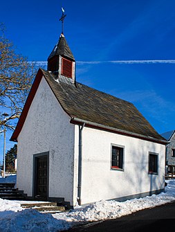
St. Lüfthildis chapel
|
||
Odesheim is a district of Bad Münstereifel in the district of Euskirchen , North Rhine-Westphalia and belongs to the village community and formerly independent municipality of Mutscheid .
geography
Odesheim is located in the northeast of the Eifel , about 15 km southeast of the old town of Bad Münstereifel. The place is embedded in the northern Eifel region , not far from Michelsberg ( 588 m above sea level ) and from Aremberg ( 623 m above sea level ). The highest point in the village is the Biersnück at 468 m above sea level. NHN . Located in a hollow on a small elevation, there is a view of the Aremberg, the Michelsberg and up to the mountain ranges of the eastern Hocheifel with Hohe Acht ( 747 m above sea level ) and Nürburg ( 679 m above sea level ).
climate
Odesheim belongs to the rain shadow area of the Eastern Eifel (in the lee of the western Hocheifel and Schneifel) and therefore only has average annual rainfall of 700 mm to 800 mm. In the village itself there is an annual average air temperature of 6.5 ° C to 7.0 ° C and a July temperature of approx. 15 ° C. The length of the growing season is 130 to 140 days. The mean beginning of apple blossom is between May 10th and 20th. The winter rye harvest begins between July 29th and August 8th.
history
Odesheim is one of the first settlements in the Mutscheid area and was probably the center of a local calendar system for determining the solstices as early as Celtic times . The name of the place is probably due to the Germanic deity Odin .
Under canon law, the place belongs to the parish of Mutscheid and, like the community of Mutscheid, looks back on a history spanning more than 1000 years. Together with Mutscheid, Odesheim was first mentioned in 893 in the Prümer Urbar together with the Hospelt estate as property of the Prüm Abbey. Originally, the community consisted of a collection of small farms that were under the Hospelt estate and served to supply the monastery in Münstereifel.
Odesheim was incorporated into Bad Münstereifel on July 1, 1969 together with the municipality of Mutscheid.
St. Lüfthildis chapel
The chapel was completed in 1752 and consecrated to St. Lüfthildis . In 1830 the roof was renovated. The roof turret houses a 25 kg bell , of which neither the year of casting nor the manufacturer is known.
traffic
The RVK bus line 819 stops in town. The TaxiBusPlus is available.
Worth seeing
- Gut Hospelt with a wildlife enclosure
literature
- The Mutscheid Association (Ed.) Mutscheid 893–1993. Our home town. Westkreuz-Verlag Berlin / Bonn, Bad Münstereifel 1993, ISBN 3-922131-92-1 .
Web links
Individual evidence
- ↑ Population figures . Retrieved March 11, 2019 .
- ^ Heinrich Klein: The peasant calendar Odesheim - calendar analyzes Michelsberg, Odesheim and Mutscheid. vorzeitkalender.de, accessed on January 26, 2016 .
- ↑ About gods, angels, fairies and dwarfs [1]
- ^ Joseph Matthias Ohlert: Almost 1000 years under the crook. In: Mutscheid 893-1993.
- ↑ Martin Bünermann: The communities of the first reorganization program in North Rhine-Westphalia . Deutscher Gemeindeverlag, Cologne 1970, p. 87 .


