Hardtburg
| Hardtburg | |
|---|---|
|
Hardtburg |
|
| Creation time : | 11th or 12th century |
| Castle type : | Niederungsburg |
| Conservation status: | ruin |
| Place: | Euskirchen |
| Geographical location | 50 ° 36 '51.3 " N , 6 ° 48' 49.9" E |
| Height: | 250 m above sea level NHN |
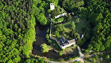
The Hardtburg is the well-preserved ruin of a moated castle from the High Middle Ages near the Euskirchen district of Stotzheim on the northern edge of the Eifel .
The main castle has been in ruins since the 18th century, but most of the castle wall and the outer bailey , which today houses a state forest ranger, are very well preserved. The castle has been maintained since 1965. It is freely accessible, but the keep is only open at certain times (autumn and winter), which depend on the breeding seasons of the birds nesting there.
description
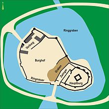
Even if the Hardtburg is on a hill of the Hardt, it is not a hilltop castle , but a moated castle. The castle complex consists of a bailey and a core castle and, together with the surrounding moat, has an area of 155 × 107 meters. The up to seven meters high, but only 60 cm thick circular wall around the entire complex extends to 119 × 66 meters.
A bridge over the moat, which was previously designed as a drawbridge , allows access to the outer bailey through a gate tower that used to have a portcullis . There are several buildings from the 18th and 19th centuries in the extensive courtyard. There is a ditch between the outer and main castle, over which a bridge used to lead into the Zwinger .
The kennel, the walls of which are about 60 cm thick and which extends to 50 × 40 m, surrounds the main castle ring. The high ring wall around the main castle, which is significantly higher than the outer castle, is 32 × 29 meters in its largest dimension. To the north, the wall is up to 2.70 meters thick, while to the south it is only about 1.6 meters thick. The approximately 20-meter-high keep , which is located on a surface area of 9.5 × 9.3 meters, has a wall thickness of 2.50 meters on the lower floor, which decreases towards the top. It can be climbed as a lookout tower at certain times of the year .
history
The castle was probably built in the 11th or 12th century. It is assumed that the builder was a Herr von Har (d) t, who appeared from 1105 onwards. The first documentary mention comes from the year 1166. In 1205 Archbishop Bruno von Sayn took the castle and partly destroyed it. It is also known that Count Friedrich von Hochstaden bequeathed the Hardtburg to the Archbishopric of Cologne in 1246 . The then Electoral Cologne Castle was until 1794 the administrative seat of the Hardt Office with an area of 12,100 hectares .
The originally primitive castle complex was rebuilt in the 13th century. The outer bailey and the Zwinger were not built until the 14th century and have been preserved to this day. As drawings from 1725 show, the castle was already in ruins at that time.
literature
- Reinhard Friedrich, Medieval ceramics from Rhenish moths. Rhine. Exp. 44, Cologne, Bonn 1998, p. 113 ff.
- Gerhard Naumann: Forest history to the Hardtwald near Stotzheim, Euskirchen district . 2nd Edition. Forestry Office Bad Münstereifel, Bad Münstereifel 1998, ISBN 3-924383-12-3 ( online ).
- Werner Sieper: The Hardtburg . In: Kreuzweingarten, Rheder, Kalkar . Zeitbiografischer Verlag, Kreuzweingarten 1969 ( online ).
- Guide to Prehistoric and Protohistoric Monuments, ed. v. RGZM, Vol. 26, Mainz 1974, pp. 159 ff.
Web links
- Entry on Hardtburg in the scientific database " EBIDAT " of the European Castle Institute
- http://www.burgerbe.de/2017/03/26/gesperrte-hardtburg-instandsetzung-fuer-2017-geplant/
Individual evidence
- ^ Hardtburg - general knowledge map on the website of Medienwerkstatt Mühlacker Verlagsgesellschaft mbH


