Rissdorf
|
Rissdorf
City of Mechernich
Coordinates: 50 ° 35 ′ 37 " N , 6 ° 42 ′ 58" E
|
|
|---|---|
| Height : | approx. 290 m above sea level NHN |
| Area : | 1.2 km² |
| Residents : | 119 (Dec. 31, 2019) |
| Population density : | 99 inhabitants / km² |
| Postal code : | 53894 |
| Area code : | 02256 |
|
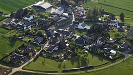
Rißdorf, aerial photo (2015)
|
|
Rißdorf is a place on the northern edge of the Eifel , which belongs to the city of Mechernich in the Euskirchen district.
Rißdorf is roughly in the center of the triangle between Mechernich, Euskirchen and Bad Münstereifel .
The Maria-Himmelfahrt chapel stands in the middle of the village. The Roman Eifel aqueduct to Cologne and the A1 motorway pass the local area directly.
On July 1, 1969, the community was Lessenich-Rißdorf after Veytal incorporated.
Individual evidence
- ^ Rissdorf. (No longer available online.) City of Mechernich, archived from the original on July 31, 2017 ; Retrieved July 3, 2017 . Info: The archive link was inserted automatically and has not yet been checked. Please check the original and archive link according to the instructions and then remove this notice.
- ↑ Martin Bünermann: The communities of the first reorganization program in North Rhine-Westphalia . Deutscher Gemeindeverlag, Cologne 1970, p. 87 .


