
Eifel Heights Route
| Eifel Heights Route | |
|---|---|

|
|
| overall length | 230 km (circular route) |
| location | Eifel / North Rhine-Westphalia |
| map | |
| Link on map | |
| Places along the way | Blankenheim , Freilingen , Lommersdorf , Ahrhütte , Alendorf , Ripsdorf , Waldorf , Dahlem , Udenbreth , Unterpreth , Hellenthal , Kalterherberg , Monschau , Hammer , Einruhr , Rurberg , Gemünd ( AltR ), Kall ( AltR ), Woffelsbach , Heimbach , Düttling , Voißel , Wallenthal , Schützendorf , Hostel , Mechernich , Breitenbenden , Vussem , Eiserfey , Keldenich , Urft , Nettersheim , Blankenheimerdorf |
| Flooring | approx. 90% asphalt or concrete, water-bound surface , forest paths |
| Height difference |
200 m to 600 m / approx. 2600 m |
| difficulty | sporty; mostly <4%; Max. 8% incline |
| Traffic volume | Mainly cycle paths and farm roads, some smaller roads |
| Connection to | Ahr bike path , Kylltal bike path , RurUfer bike trail , valleys route , Vennbahnradweg |
| ADFC certification |
Description at ADFC ADFC classifications |
| Website URL | www.eifel-hoehen-route.de |
The Eifel-Höhen-Route is a cycle path that leads through the northern Eifel on a 230 kilometer (km) long circuit . He circles the Eifel National Park with its large reservoirs, crosses the Hohes Venn-Eifel nature park and pays a visit to the rivers Ahr , Urft , Kyll and Rur . The route is shaped by the natural landscapes of the Eifel, but also offers some historical places such as Monschau and Blankenheim as well as the former NS-Ordensburg Vogelsang . The route runs mainly on cycle paths and farm roads, but sometimes also on smaller roads. The route is only partially suitable for racing bikes. In terms of fitness requirements, she is described as "sporty". The route is uniformly signposted in both directions with the bike path logo.
Route Blankenheim – Monschau – Heimbach – Blankenheim
Characteristic
The circular route moves in low mountain ranges between 200 m and 600 m and is consistently hilly. Most of the increases remain moderate at less than 5%. After Blankenheim, however, there is an incline of 5% on a 1 km route. Then it's hilly (an increase of up to 7%) via Ahrhütte in the Ahr valley to Alendorf. From there there is a longer increase of up to 7% before Dahlem is reached. The next 35 km is relatively leisurely (only short climbs up to a maximum of 6%), before halfway between Hellenthal and Kalterherberg, another 2 km ascent with a 7% gradient has to be overcome. From Kalterherberg, where it also meets the Vennbahn , the route runs along with the RurUfer cycle path to Heimbach on a family-friendly route. A few climbs can be avoided if you follow the RurUfer cycle path instead of the Eifel-Höhen route on this section. After Heimbach, the route becomes sporty along the northern border of the Eifel National Park. Several climbs between 5% and 8% have to be mastered before reaching Mechernich. The last section of the circuit leads with another 5% gradient to Keldenich , then down into the Urft valley, almost flat to Nettersheim and Blankenheim-Wald, before reaching Blankenheim again after a last slight ascent.
There is an alternative route through the Eifel National Park that leads from Rurberg via Gemünd and Kall to Wallenthal.
The Eifel-Höhen-Route is signposted throughout. Most of the route is paved or concreted, the remaining part leads over water-bound ceilings or natural forest paths. The route is almost exclusively via cycle paths or farm roads. Some connecting routes run on secondary roads.
The Eifel-Höhen-Route can be reached by train via the Cologne-Trier railway line or the Düren – Heimbach railway line . The ADFC classifies them as follows:
- The surface is approx. 60% suitable for racing bikes, approx. 40% for touring bikes.
- The difficulty is given as approx. 25% easy, approx. 70% medium, approx. 5% difficult (from: easy 0–2%, medium 2–6%, difficult 6–10%, sporty> 10%).
- The traffic load is given as "none to low" (from: "none to low", moderate, high)
Blankenheim-Hellenthal
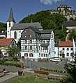
Parish Church and Blankenheim Castle

Ahrquelle in Blankenheim
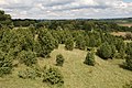
Juniper heather in the Lampert Valley

Dahlem Binz airfield
The cusp line of the west wall near Udenbreth
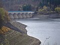
Oleftalsperre, lake side at low tide

Landscape in the High Fens

Eifel Cathedral in Kalterherberg

White water of the Rur in Monschau

The "Red House" in Monschau

Obersee between Einruhr and Rurberg
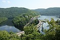
Urft dam near Schleiden

NS-Ordensburg Vogelsang

Aerial view of the Rurtalsperre Schwammenauel

Heimbach Art Nouveau power plant

Heimbach Castle

Aqueduct bridge in Vussem


The first section is about 68 km long and has about 926 vertical meters ascent.
In Blankenheim, the Ahr rises below a half-timbered house. During a tour of the medieval town, you can visit the 500 year old late Gothic parish church, the town gates, the castle and the Eifel Museum . From Blankenheim the path leads up to the Mühlheimer Heide. From there the route runs downhill through the village of Mühlheim to the Mühlheimer Mühle. We continue through forests and meadows over a hill (approx. 70 meters in altitude), past the Freilinger See (K41) down to Freilingen. The route continues on the quiet district road 41 over a slight ascent to Lommersdorf. Away from this country road, the path now leads down into the Ahr valley and, together with the Ahr cycle path , gently ascending to Ahrhütte. Here the Eifel high route leaves the Ahr valley again and leads with a 2.8% gradient and over 75 meters up to Dollendorf with its castle ruins . The path now leads over a slight incline into the Lampert Valley and along the course of the stream, through forest and meadows over a gentle but long incline (approx. 100 meters in altitude over 5 km) to the village of Alendorf. The route leads directly past the Kalvarienberg. This is part of the largest juniper conservation area in North Rhine-Westphalia. The Kalktriften corridor in the Alendorf district has been under protection since 1953 . Plants of great rarity have developed on the chalky subsoil. The route then leads around 2 km with a steeper gradient (max. 6%) on the K 43 to Ripsdorf. From here it goes down to the Schaafbach and the Ripsdorfer Mühle. After a good 1 km, the valley of the Schaafbach is left behind the sewage treatment plant and an approx. 5 km long ascent leads to a 7% gradient over the village of Waldorf on the Hahneberg. Now it only goes downhill through meadows and fields to Dahlem, with which the first 40 km of the circuit are completed. In Dahlem the route leads past the train station. This is on the Eifel route that connects Cologne and Trier. The path from Dahlem leads over the original road, with climbs to be mastered once again. First on about 3 km about 3% gradient and then again a little flatter with 2.5% on about 4 km. The path leads past the Trappist Abbey of Maria Frieden , the only abbey of the silent nuns in Germany, the Dahlemer Binz kart track and the Dahlemer Binz airfield . Now the route now leads over the state road 110 to Udenbreth . On the way the radio station Bärbelkreuz will be passed near Neuhaus . After Udenbreth, the path now leads over farm tracks down around 250 meters in altitude through the Preth valley to Hellenthal. The route passes the Udenbrether mill, the Oberprether mill near the village of Ramscheid and the village of Unterpreth .
Hellenthal-Rurberg
This section is about 56 km long and has a climb of around 640 meters.
Hellenthal is the terminus of the Oleftalbahn . From 2012 a museum train will run here again from May to October on Sundays and public holidays. In Kall, the line has a connection to the Eifelbahn Cologne-Trier.
In Hellenthal there is a game reserve with a bird of prey station, which offers flight demonstrations with eagles, buzzards and falcons from April to October. It is also worth taking a detour from here to the castle village of Reifferscheid , around 4 km away , a typical example of a Gothic castle valley settlement in the Eifel. The route now leads over a steep incline (approx. 50 meters in altitude with a maximum of 6%) to the crown of the Oleftalsperre , where the effort is rewarded with a beautiful view of the reservoir. The construction of the dam in pillar cell construction is still unique in Germany today. The further path leads almost flat on the northern bank of the reservoir. After the end of the reservoir, the path follows the Olef for a few hundred meters, which feeds the reservoir, before continuing through the foothills of the High Fens . The first ascent after the reservoir overcomes around 45 meters in altitude over a length of around 2 km with a maximum gradient of 7%. After a descent, there are two more small climbs of around 5% before reaching Kalterherberg . The route leads through extensive forest areas and follows the Furthgesweg through the Perlenbach-Fuhrtsbachtal nature reserve. In Kalterherberg there is the St. Lambertus Church , known as the Eifeldom . The border town to Belgium, as the name suggests, is the first to experience the bad and cold weather from the High Fens. House-high beech windbreak hedges provide a remedy. Kalterherberg is a typical example of the Monschau Heckenland . In this area of North Rhine-Westphalia, the node system adopted from the Netherlands has been introduced for better orientation. If available, the node numbers (node x) are given below. Behind Kalterherberg the Eifel high route runs together with the RurUfer cycle path to Monschau (junctions 39, 30, 32). The route follows the course of the Rur and leads past the “Kreuz im Venn”, a six-meter-high iron memorial cross erected on a rock, and the former Reichenstein monastery , to the climatic health resort of Monschau with its historic old town. The path continues through the Monschauer Land along the deeply cut Rur to Einruhr (junction 36) on the Obersee of the Rur reservoir . On the first 9 km to the village of Hammer there are two short steep climbs with about 50 and 25 meters in altitude to overcome. This is followed by another 8 km with more or less steep hills to Einruhr. Above the lake, after 4 km, Rurberg with the Rursee Center and the "Eifel National Park" of the Eifel National Park is reached. There are another 65 vertical meters with max. 5% incline to be mastered. At this point you have to decide whether you want to follow the route further around the Rursee or the alternative route along the Urftstausees through the national park.
Rurberg – Heimbach – Mechernich
This section is about 50 km long and has an elevation gain of around 682 meters.
On the western bank of the Rur reservoir, the main route leads via Woffelsbach to the Schwammenauel dam. From here the path then leads down to the foot of the dam to Heimbach-Hasenfeld with its Art Nouveau power station. Together with the RurUfer cycle path, the route runs for around 2 km along the Rur to Heimbach with Hengebach Castle, the "Pilgrimage Church of St. Clemens and Christ Salvator" and the Eifel Water Information Center . The Mariawald Abbey is not far from Heimbach . Heimbach is also the terminus of the of Jülich here leading Rurtalbahn . Here the route leaves the Rur and heads south-east on the edge of the Eifel National Park. First of all there is a 4 km long ascent with up to 8% incline to be overcome before a 2 km long descent follows. The path leads through a wooded area over the Heimbachtal to the Hergarten districts and reaches open terrain before Düttling. The route leads to the Mechernian district of Bleibuir, which is very hilly. Behind Bleibuir, another 130 meters in altitude with an incline of up to 7% have to be overcome over 3 km, before it then goes mainly downhill to Mechernich. On the way you pass Voissel, Wallenthal, Schützendorf and Hostel.
Rurberg – Kall – Mechernich (alternative route)
This section is about 35 km long and has a climb of around 225 meters.
It leads through the Eifel National Park and joins the main route behind Kall.
Before Rurberg, the alternative route branches off to the right over the dam, which separates the Rurstausee from the Upper Upper Lake basin . The path now runs on the northern bank of the Obersee before reaching the Urft dam after about 5 km. This separates the Urftstausee from the Obersee. On the banks of the Uftsee, the route reaches the bridge after another 6 km, which branches off to the former NS-Ordensburg Vogelsang. In the years 1936 to 1939, the castle complex , which was specially set up for this purpose, was used as a so-called NS-Ordensburg and served to train the leadership of the NSDAP . After the Second World War, the area was part of the Vogelsang military training area . The facility has been used as a memorial site since 2006. After another 4 km along the now ending Urftsee, the Kneipp health resort Gemünd is reached. Except for an ascent of around 40 meters in altitude with a maximum gradient of 5%, this section is completely flat so far. After Gemünd, the route follows the Urft valley and reaches the municipality of Kall after the Anstois district, without a major climb. The Kall train station is on the Eifel line from Cologne to Trier. After Kall there is a moderate gradient of up to 4% for around 1 km before this path joins the main route and leads down via Wallenthal, Schützendorf and Hostel to Mechernich.
Mechernich – Blankenheim
The last section is about 34 km long and has about 530 vertical meters of climbs.
The Mechernich train station is on the Eifelbahn route from Cologne to Trier. In Mechernich there is also the mining museum and visitor mine Mechernischer Bleigrube , the Kakushöhle and remains of the Roman Eifel aqueduct in the district of Vussem. It is also worth making a detour to the nearby Kommern with the largest closed half-timbered ensemble in the Rhineland or to Satzvey Castle , one of the best preserved moated castles in the Rhineland. Behind Mechernich, the route leads with only a slight ascent through meadows and fields through the towns of Breitenbenden, Vussem, Eisenfey, Vollem and Urfey before it gets steeper in the forest. Over a distance of 5 km there are about 130 meters of altitude to be overcome with up to 6% incline. Then, after a 2 km descent into the Urft valley , which is reached near the village of the same name, it is almost flat to Nettersheim. A few kilometers from Urft is the remarkable Steinfeld Monastery with its 12th century basilica. Both Urft and Nettersheim have train stations on the Eifelbahn. In Nettersheim there is the Eifel Nature Conservation Center , a historic lime distillery and the start of the Römerkanal hiking trail , which leads along the Eifel aqueduct built by the Romans to supply Cologne. With the Eifelbahn route further in the Urft valley, the route climbs slightly to the Blankenheim Wald train station, which is reached after a short descent. Then the path runs with a moderate gradient (short section with 5%) via Blankenheimerdorf back to the starting point Blankenheim, which is reached after a last descent.
Connecting cycle paths
The Ahr cycle path starts in Blankenheim and touches the route again in Ahrhütte before continuing to its confluence with the Rhine. Dahlem with its train station on the Eifel route is an entry point to the Kylltal cycle path . The RurUfer-Radweg and the Eifel-Höhen-Route run together between Kaltenbergen and Rurstausee . The valley route runs at Hellental and between Mechernich and Blankenheim partly together with this route. The valley route connects to the Erft cycle path in Nettersheim.
Train and bus connections
The Eifel-Höhen-Route connects to several Eifelbahn Cologne-Trier train stations on the Mechernich – Dahlem section. In addition to these, the stations Kall, Urft, Nettersheim and Blankenheim-Wald are ideal for starting the circuit. Another possible entry point is Hellenthal at the Oleft reservoir. A museum railway has been leading here since 2012, which resumes traffic on the Oleftalbahn route from May to October on Sundays and public holidays. In Kall, the line has a connection to the Eifelbahn Cologne – Trier. Access is also possible via the Rurtalbahn with its Heimbach terminus. This railway line begins in Jülich and runs over Düren, which is on the Cologne-Aachen railway line .
Landscape and culture
The panorama route around the Eifel National Park is essentially determined by the diverse natural landscapes. Sometimes the route leads over open plateaus, sometimes through dense coniferous forests like on the Dahlemer Binz, sometimes through narrow gorges like the juniper-lined Lampertstal, sometimes wide panoramic views as far as the High Fens. The most beautiful views are explained by "Eifel views" signs, such as in Monschau, Udenbreth or Nettersheim. Whether wild narcissus meadow in Hollerath or the reservoir landscape of Rursee, Urftsee and Obersee - the views surprise every time anew. In the middle of the route is the Eifel National Park, the only one of its kind in western Germany. Themed exhibitions in the five national park gates, for example in Rurberg or Gemünd, clearly explain flora and fauna. But there are also scenic pearls to discover outside the national park, be it the Monschauer Heckenland, the Oleftalsperre with neighboring birds of prey station and game reserve or the idyllic Urft valley with the Eifel nature center in Nettersheim. There is also something for those interested in history on this route.
From the prehistoric Kakushöhle south of Mechernich to Roman witnesses such as the former aqueduct to supply ancient Cologne to the medieval castles of Hengebach and Blankenheim to the former NS-Ordensburg Vogelsang, diverse traces of bygone times can be discovered. A detour to the LVR open-air museum in Kommern offers insights into earlier, rural living conditions.
Attractions
- Blankenheim with its historic town center offers half-timbered buildings in romantic corners and alleys. The Ahr spring is located here in the cellar of a half-timbered house, remains of the former city fortifications with the Georgstor from 1670 and the shepherd's tower from 1404, as well as the late Gothic parish church of St. Mary's Assumption, which was completed in 1505. Above the village is Blankenheim Castle from the 12th century, which now houses a youth hostel. In the Eifelmuseum Blankenheim, the regional museum for natural history and cultural history, there are permanent and changing exhibitions. The historical carnival museum in Georgstor impressively explains 400-year old Blankenheim carnival customs, in particular the Blankenheim ghost train.
- In the municipality of Dahlem , the route leads past the Trappist convent Maria Frieden , the Dahlemer Binz airfield and the "Dahlemer Binz kart track".
- In the district of Rescheid in the municipality of Hellenthal , not far from the cycle route, there is the visitor mine Grube Wohlfahrt . A former lead ore mine where guided tours are offered daily. The main town lies below the Oleftalsperre . Above him is the Hellenthal game reserve with a bird of prey station. This offers an air show with eagles, buzzards and falcons. From mid-April to early May, millions of wild-growing "yellow daffodils" bloom in the meadow valleys of the upper Oleftal.
- Kalterherberg with its Eifeldom and the parish church of St. Lambertus . Located directly on the High Fens, this border town with Belgium is the first to experience the bad and cold weather. House-high beech windbreak hedges provide a remedy. Kalterherberg is a typical example of the Monschau Heckenland . The Reichenstein Abbey above the Rur is also located in the municipality.
- Monschau is known for its historic old town. The 12th century castle still dominates the old town with its half-timbered and quarry-stone houses, which dates back to the heyday of early industrial cloth production. A particularly impressive example is the Rote Haus , which is now a museum and built by the Scheibler family of manufacturers around 1760 .
- Heimbach, located at the foot of the Rursee dam Schwammenauel, offers a number of sights. These include the Art Nouveau power plant , which was the largest hydroelectric power plant in Europe when it opened in 1905. It is located on the Rursee, but gets its water from the Urftsee, to which it is connected via two pressurized water pipes with a height difference of 110 m. The RWE Industrial Museum is located in the completely preserved Art Nouveau building, which is unique in Europe . One of the old turbines with the brass fittings customary at the time can be seen in it. Above it are the castles Hengebach and Hausen , the Eifel Water Information Center and the "Heimbach National Park " of the Eifel National Park . Near Heimbach is the Mariawald Abbey , a monastery of the Cistercian order that is still active today .
- The Kneipp health resort Gemünd is the largest district of Schleiden , around 50% of which is part of the Eifel National Park. One of the five centers is located here, the so-called "National Park Gates", which provide comprehensive information about the National Park. The confluence of the Olef and Urft is also in Gemünd . The former NS-Ordensburg Vogelsang is located in the urban area of Schleiden .
- A wayside shrine from 1734 can be found in the municipality of Kall . The Madonna and Child in this wayside shrine is particularly venerated by the parish of St. Nicholas. The original of the Madonna and Child comes from the 14th century and is now in the parish church. The Primbsch Museum is located in the Kendenrich district. A private art museum that shows the works of painter EO Primbsch on a wide variety of painterly subjects such as landscapes and flowers as well as socially critical pictures. The former Premonstratensian Abbey of Steinfeld Monastery with its important basilica from the early 12th century is also located in the municipality near the bike route . Visible from afar, on a hill in the south of the municipality of Kall, the "Eifelkloster" forms the district of Steinfeld with a few surrounding houses.
- Mechnich is home to the Landesmuseum für Volkskunde, the LVR open-air museum Kommern , in its district of Kommern , located around 2 km to the north . With over 80 hectares it is one of the largest open-air museums in Europe and shows 65 historical buildings from the Prussian Rhine province. In Mechnernich there is also the mining museum and visitor mine Mechernischer Bleigrube , the prehistoric Kakushöhle and remains of the Roman Eifel aqueduct in the district of Vussem.

literature
- ADFC regional map Eifel / Mosel , 1: 75,000. Bielefelder Verlag, 1st edition. 2006, ISBN 3-87073-391-8 .
- North Eifel. On the valley routes, the moated castles and Eifel height routes. ADFC -Radausflugsführer 1: 50,000, BVA Bielefelder Verlag , 2013, ISBN 978-3-87073-594-4 .
- Euskirchen district cycling map. 1: 50,000. Topographic map of North Rhine-Westphalia. May 2008, ISBN 978-3-87073-451-0 .
Web links
- Official website of the Eifel-Höhen-Route
- Route at OpenStreetMap
- Eifel-Höhen-Route at eifel-blicke.de
- Information on the Eifel-Höhen-Route from Eifel Tourismus
- A travel report on the Eifel-Höhen-Route
- radwanderland.de
Coordinates: 50 ° 35 ′ 19.3 " N , 6 ° 39 ′ 47.6" E