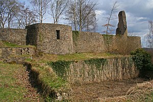
Dollendorf Castle
| Dollendorf Castle | ||
|---|---|---|
|
Castle ruins in Schloßthal |
||
| Alternative name (s): | Finger of God, Schlossthal | |
| Creation time : | at 893 | |
| Castle type : | Hilltop castle | |
| Conservation status: | Tower and wall remains | |
| Standing position : | Nobles | |
| Place: | Schlossthal | |
| Geographical location | 50 ° 23 '25 " N , 6 ° 42' 42" E | |
|
|
||
The ruins of Dollendorf Castle are located in Schloßthal, a district of the municipality of Blankenheim in the Eifel .
Explanation about the castle
Dollendorf Castle is the ruin of an old hilltop castle that served as a residence for the noble people of Dollendorf, first mentioned in 893, until the middle of the 15th century. The castle was first mentioned in a document in 1077. In the 12th century it became a Cologne fiefdom, in the 13th century it came under the fiefdom of the Counts of Luxembourg and the Counts of Jülich.
Because of its silhouette, which can be seen from a distance, it is also known as the finger of God . This name comes from the fact that half of the 20 meter high keep remained standing. Since the castle is on a hill, you can see the top of this tower even from a great distance. People called them God's fingers because this tower resembles the shape of a finger and rises high into the clouds. Its floor plan can still be seen clearly, and some of the higher walls are still well preserved.
The current use of the ruin
Since not many tourists come to Schloßthal, this monument cannot establish itself as a recognized sight. However, it gives everyone interested an insight into the architecture; Information signs provide information about the use of the castle at that time and about its former residents. Today tourists and the residents of Schloßthal use the castle grounds as a fireplace. Many residents also have a custom to celebrate the New Year there, so the ruin is an impressive sight, especially on the first day of the year.
The rest of Neuweiler Castle is about 250 meters below Dollendorf Castle.
Web links
- Entry by Hans-Jürgen Greggersen zu Dollendorf in the scientific database " EBIDAT " of the European Castle Institute
- Entry on Dollendorf in the private database "Alle Burgen".
Individual evidence
- ↑ a b The Ahr Valley Cycle Path. (PDF; 1 MB) Cycling adventure routes on the Upper Ahr. (No longer available online.) Touristikverein Blankenheim - Oberes Ahrtal eV, May 10, 2006, archived from the original on February 3, 2013 ; accessed on February 17, 2014 (Flyer). Info: The archive link was inserted automatically and has not yet been checked. Please check the original and archive link according to the instructions and then remove this notice.


