
Dahlem (North Eifel)
| coat of arms | Germany map | |
|---|---|---|

|
Coordinates: 50 ° 23 ' N , 6 ° 33' E |
|
| Basic data | ||
| State : | North Rhine-Westphalia | |
| Administrative region : | Cologne | |
| Circle : | Euskirchen | |
| Height : | 500 m above sea level NHN | |
| Area : | 95.21 km 2 | |
| Residents: | 4215 (Dec. 31, 2019) | |
| Population density : | 44 inhabitants per km 2 | |
| Postal code : | 53949 | |
| Primaries : | 02447, 06557 | |
| License plate : | EU, SLE | |
| Community key : | 05 3 66 012 | |
| Address of the municipal administration: |
Hauptstrasse 23 53949 Dahlem |
|
| Website : | ||
| Mayor : | Jan Lembach ( CDU ) | |
| Location of the community of Dahlem in the district of Euskirchen | ||
  |
||

Dahlem in the Eifel is a municipality in the Euskirchen district . It has the lowest population and population density of all municipalities in North Rhine-Westphalia .
Geographical location
Dahlem is located in the northern Eifel region in the High Fens-Eifel between Blankenheim in the Northeast and Stadtkyll in the southwest. To the south, the community borders on the Gerolstein association , which is already in Rhineland-Palatinate . The Kyll tributary Glaadtbach flows through it . In the Ripsdorf forest to the east are the Heidenköpfe .
Community structure
_001x.jpg)
The municipality of Dahlem consists of the following districts:
- Baasem
- Berk
- Dahlem
- Women's crown
- Kronenburg
- Schmidtheim
history
Finds of broken bricks from Roman times (50 BC to 400 AD) were made near the Roman road Trier-Neuss , east of the so-called "barrows". In the corridor “Im Leger”, cremation graves with additions were discovered.
Dahlem was first mentioned as dalaheim in a deed of donation from nobleman Otbert, issued in Aachen in Latin, dated January 20, 867:
“And so the aforementioned Otbert gave (us) a small farm in the village of Dahlem in the Eifelgau in the village of Dahlem, where 100 hooves can be cultivated and (a forest) where 1000 pigs can be fattened . But this forest is between Schmidtheim and Baasen. "
In the 19th century, Dahlem was still known as Dalheim. The name is derived from "Talheim".
Incorporations
As part of the local government reform on July 1, 1969, the former municipalities of Baasem, Berk, Kronenburg and Schmidtheim were incorporated. The administrative headquarters are in Schmidtheim.
politics
Municipal council
The municipal council is the local people's representative for the municipality of Dahlem. The citizens decide on the composition every five years. The last election took place on May 25, 2014.
partnership
Dahlem is with the French community Sarzeau in Brittany twinned .
Coat of arms and banner
coat of arms
|
|
Blazon : “Divided from silver (white) to red; above a growing gold (yellow) armed red eagle, below three (2: 1) slanting silver (white) hammers. " |
| Justification of the coat of arms: The eagle indicates the former rule of Kronenburg; the hammers come from Schmidtheim's official coat of arms. They refer to the iron industry in the Dahlem area. |
The municipality was granted the right to use a coat of arms, a seal and a flag (banner) in a certificate from the district president dated April 6, 1976.
banner

banner
"Red-white in a ratio of 1: 1 striped lengthways with the coat of arms of the municipality shifted upwards over the middle."
traffic
The stops in Dahlem and Schmidtheim on the Eifel route Cologne - Euskirchen - Gerolstein - Trier are served by an RE line every hour.
The connection of the rear districts (Kronenburg, Frauenkron, Berk) to the Dahlem train station takes place Mon – Sat every hour via the RVK bus line 834 . Outside of school traffic, the taxi bus is used, i. H. the trips only run on tel. Pre-registration. The tariff of the Verkehrsverbund Rhein-Sieg applies and the NRW tariff applies to all tariff areas .
The B 51 and B 421 pass through the municipality of Dahlem . About in this section three lanes Equipped B 51 is A 1 reachable.
The Dahlemer Binz public airfield is located between Dahlem and Schmidtheim .
Sightseeing and tourism
- Views of Dahlem
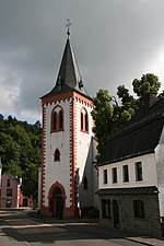
Parish church of St. Hieronymus from 1891 in Dahlem

Church of St. Mary's Birth Baasem

Dahlemer Binz

Marienallee natural monument in Dahlem

Castle ring in Kronenburg


- Castle ruins and medieval town center in Kronenburg with a late Gothic church
- Kylltalsperre (Kronenburger See) in Kronenburg
- Trappist Abbey Maria Frieden in Dahlem
- The church of St. Mary's Birth (Baasem) in its current form dates from the middle of the 15th century and is a listed building .
- Dahlemer Binz airfield in Dahlem
- Kart track Dahlemer Binz
- Schmidtheim Castle : today's castle, originally a moated castle, essentially dates from the first half of the 17th century; the moats were filled in in 1890. The castle is one of the best preserved in the Eifel. The park with trees (today natural monuments) is worth seeing.
- The Eifel-Höhen-Route cycle path , which runs around the Eifel National Park , leads through the village .
- Dahlem is a possible starting point for the Kyll cycle path , which has been running on the former railway line from the Belgian border to Stadtkyll since 2015.
- On the outskirts of Dahlem, the moor path leads through the hillside moor on the Wasserdell.
- The valley route cycling route also leads through the village.
Sons and daughters of the church
- Innocent Wolf (1843–1922), Benedictine Abbot of St. Benedict's Abbey in Atchison, Kansas USA, Abbot President of the American-Cassinese Benedictine Congregation
- Hubert Knackfuß (1866–1948), building researcher and archaeologist
- Wilhelm Gier (1867–1951), Steyler missionary , priest and superior general, author of spiritual writings
- Johann Peter Brandenburg (1905–1977), politician (FDP / DVP), member of the Landtag in Baden-Württemberg , Landtag Vice-President, Lord Mayor of Pforzheim
- Mathilde Grün (* 1910), née Dederichs, the mother of Anselm Grün
- Fabian Ewertz (* 1981), former professional footballer (VfL Osnabrück, Alemannia Aachen)
Web links
Individual evidence
- ↑ Population of the municipalities of North Rhine-Westphalia on December 31, 2019 - update of the population based on the census of May 9, 2011. State Office for Information and Technology North Rhine-Westphalia (IT.NRW), accessed on June 17, 2020 . ( Help on this )
- ↑ Martin Bünermann: The communities of the first reorganization program in North Rhine-Westphalia . Deutscher Gemeindeverlag, Cologne 1970, p. 100 .
- ^ Dahlem parish. European / Local elections 2014. May 25, 2014, accessed on November 4, 2014 .
- ↑ Main statute of the municipality of Dahlem, § 2. (PDF; 71 kB) Retrieved on December 31, 2012 .
- ↑ Gudrun Klinkhammer: “Don't leave anyone standing in front of the door”. In: Kölner Stadt-Anzeiger. September 30, 2013, accessed April 15, 2014 .
- ^ About the person: Fabian Ewertz. In: Kölner Stadt-Anzeiger. February 10, 2012, accessed February 22, 2018 .
Bad Münstereifel | Blankenheim | Dahlem | Euskirchen | Hellenthal | Kall | Mechernich | Nettersheim | Schleiden | Weilerswist | Zülpich
Baasem | Berk | Dahlem | Women's crown | Kronenburg with Kronenburgerhütte | Schmidtheim