
Ville (Rhineland)
| Ville | ||
|---|---|---|
| Highest peak | Glessener Höhe ( 205.8 m above sea level ) | |
| location | Rhein-Erft district and Rhein-Sieg district ; North Rhine-Westphalia ( Germany ) | |
|
||
| Coordinates | 50 ° 51 ′ N , 6 ° 51 ′ E | |
| Type | Half Horst | |
| rock | River / main terraces gravel | |
| particularities | Lignite , Rhineland Nature Park | |


The Ville [ ˈf̠ɪlə ] in the Rhein-Erft-Kreis and Rhein-Sieg-Kreis , North Rhine-Westphalia , is a maximum of 205.8 m above sea level. NHN high ridge in the Lower Rhine Bay .
etymology
The current name "Ville" is possibly derived from an old Franconian word * feli, * fili , which could have had the meaning of '(high) level' or 'heather'. In some historical maps and field names, the spelling with f can still be found.
geography
location
The Ville extends in a north-north-west-south-south-east direction between the cities of Grevenbroich and Pulheim in the north-north-west, the cities of Cologne , Brühl and Bonn in the eastern Rhine Valley , the Hardtbach in the southeast, the Voreifel in the south, the Swist in the southwest to the west and the Erft in the north-west. It is part of the Rhineland Nature Park . Its highest point is the artificially created Glessener Höhe ( 205.8 m ).
Natural structure
In terms of natural space , the Ville represents a main unit (three-digit) of the Lower Rhine Bay , which is divided into sub-units (decimal places ) as follows:
- (55 Lower Rhine Bay)
- 552 Ville (262.3 km²)
- 552.0 Neurath Loess Heights
- 552.1 Villehöhe , the real Ville
- 552.10 Brown Coal Ville
- 552.11 Wald-Ville
- 552.2 Villehang (foothills)
- 552 Ville (262.3 km²)
Surveys
The natural profile of the northern Villerücken was almost completely removed and redesigned in the course of the lignite mining. Today's high points of the northern Ville are mostly artificial, man-made elevations.
The southern part of the Ville (from around today's A 553 motorway ), however, still has the natural profile.
The elevations of the Ville include - sorted by height in meters (m) above sea level (NHN):
- Glessener Höhe (205.8 m), Hochkippe near Bergheim
- In the Kottenforst (approx. 180 m natural height)
- Hill (174.9 m), east of Buschhoven
- Hennesenberg (164 m), near Roisdorf
- Röttgenhöhe (163.2 m), near Kerpen-Horrem
- Hill (155.4 m), near Weilerswist
- Wilhelmshöhe (154.9 m), high point on the Hürth / Frechen border
- Hill (138.2 m), corner of Bertramsjagdweg / Industriestraße, highest natural height in Hürth - Knapsack
- Wiedenfelder Höhe (133.9 m), near Bergheim-Niederaussem
geology
The Ville is a geological half-nest that remained when the Cologne Bay subsided. The eastern edge of the Ville is overprinted by the erosion of the Rhine . The fault line to the west to Swist and Erft can be seen more clearly (see geology of the Lower Rhine Bay ). The Ville thinks north. It is up to 180 m high in the Kottenforst . In the north it disappears and goes north of Frimmersdorf ( 98 m ) into the Jülich-Zülpicher Börde .
Promontory
The eastern slope of the Ville towards the Rhine plain is called the foothills from Frechen or, more clearly, from Hürth-Kendenich to Bonn-Duisdorf . It is characterized by intensive vegetable and fruit cultivation. Due to the leeward location to the Ville, this landscape is sheltered from the wind and favored by a mighty loess cover . In the past even wine was grown here. Numerous corridor and street names are evidence of this.
The typical villa landscape in the foothills:
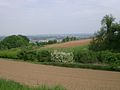
… Summer, …
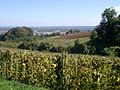
... autumn and ...
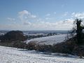
… Winter


Industrial landscape
From Brühl onwards, the Ville is characterized by the lignite mining , the power plants and the energy-intensive chemistry in the Rhenish lignite area. Railway lines were particularly important for industrial development. The first railway that crossed the Ville and connected the Brühler Gruben was the Eifel line with the Kaiserbahnhof in Kierberg . Today there are no more open-cast mines in the Ville area. The Villebahn and the Mödrath-Liblar-Brühler Eisenbahn have long been discontinued. Nevertheless, the industrial transformation remains recognizable in the landscape.
Tilts and remaining open pit holes
The backfilling of overburden from lignite opencast mines resulted in high tilts in the northern Ville - for example the Glessener Höhe ( 205.8 m ). In the surface mining pits in the mines, numerous lakes and ponds emerged that Ville lakes .
Recreational landscape
The forests of the southern Ville (Waldville) and the Kottenforst were already electoral hunting grounds. This and the recultivated landscape of the middle Ville with its villa lakes serve the people in the greater Cologne / Bonn area as a local recreation area . The Rhineland Nature Park can be seen as a third green belt for Cologne . Part of the recultivation is also left to its own devices and designated as a nature reserve with limited access. Parts of the northern Braunkohlenville from Berrenrath were also recultivated for agriculture. Since the emissions of the industry there have decreased significantly due to new technologies and only three coal refiners exist, recovery can also be found here.
special offers
- The Villeweg , designated by the nature park, leads from the Birkhof riding stables at the Brühl-Süd junction of the 553 federal motorway over the partly open, partly forest-covered villa height to Kottenforst train station . There is a gastronomic offer at both points.
- Of Lüftelberg across the Ville to Rösberg and along until then at the promontory Hürth a section of the leads Eifelverein supervised Romans channel trail - distance route from the Eifel to Cologne .
- The Marienfeld is a newly developed hiking area between Kerpen and Frechen .
- The Villehaus der Naturfreunde in Kendenich has existed as a youth hostel since the 1920s .
- Local hiking clubs have signposted circular hiking trails around Bornheim , Kendenich and Alt-Hürth .
- The road of energy on the western edge of the Ville shows points of energy generation as an adventure road .
Individual evidence
- ↑ a b Topographical Information Management, Cologne District Government, Department GEObasis NRW ( Notes )
- ^ Heinrich Dittmaier : The name 'Eifel' . In: Rheinisch-Westfälische Zeitschrift für Volkskunde , Volume VIII, Bonn and Münster 1961. Pages 168–175.
- ↑ cf. Jean Joseph Tranchot : Topographical survey of the Rhineland , 1801–1814.
- ^ Heinrich Dittmaier : Rheinische Flurnamen , Ludwig Röhrscheid Verlag, Bonn 1963.
- ^ Emil Meynen , Josef Schmithüsen : Handbook of the natural spatial structure of Germany . Federal Institute for Regional Studies, Remagen / Bad Godesberg 1953–1962 (9 deliveries in 8 books, updated map 1: 1,000,000 with main units 1960).
-
↑ Various authors: Geographische Landesaufnahme: The natural spatial units in single sheets 1: 200,000 . Federal Institute for Regional Studies, Bad Godesberg 1952–1994. → Online maps
- Sheet 108/109: Düsseldorf / Erkelenz (Karlheinz Paffen, Adolf Schüttler, Heinrich Müller-Miny 1963; 55 pages)
- Sheet 122/123: Cologne / Aachen (Ewald Glässer 1978; 52 pages)
- ↑ Height information according to the digital terrain model (available in the TIM-online map service )
- ↑ Wandergesellen Alt-Hürth ( Memento of the original from March 15, 2012 in the Internet Archive ) Info: The archive link was inserted automatically and has not yet been checked. Please check the original and archive link according to the instructions and then remove this notice. (Accessed February 2012)
literature
- Elisabeth Zenses: Landscapes between the Rhine and Eifel - The Villerücken. Information series of the Zweckverband Naturpark Kottenforst-Ville (Hrsg.) Issue 2, 2002
- Jürgen Bartel, Rainer Zschocke: The Ville and the Cologne brown coal area. In Cologne Bay and adjacent areas , Geographischer Führer Collection, Vol. 6, Berlin / Stuttgart 1972
- Horst Bursch: Origin and meaning of the landscape name "Ville". In: Weilerswister Heimatblätter , issue 37, 2009