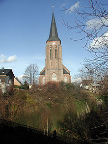
Kierberg
|
Kierberg
City of Brühl
Coordinates: 50 ° 50 ′ 15 ″ N , 6 ° 53 ′ 8 ″ E
|
|
|---|---|
| Height : | 97 m above sea level NHN |
| Residents : | 4265 (Dec. 31, 2017) |
| Incorporation : | 1932 |
| Postal code : | 50321 |
| Area code : | 02232 |
Kierberg is a north-western part of the city of Brühl in the Rhein-Erft district and is located on the eastern edge of the foothills .
location
Kierberg is located on the upper eastern slope of the Ville in the foothills and on the western edge of the inner Cologne Bay . Neighboring towns are the districts of Heide and Vochem and Brühl city center. The city center of the main town Brühl is about two kilometers away.
history
Merovingians
The origins of today's place Kierberg go back to the 7th century. Under the Cologne bishop Kunibert , the Fronhof "Merreche" (= curtis in myrica ; German: "Hof in der Heide") from the Franconian royal estate was given to the Cologne church. This early name later becomes the term "Meregge", or "Merrechte" and "Merrich". After the construction of a first chapel and a later church on the mountain, the name Kirberg emerged and became today's Kierberg.
middle Ages
Also in the 12th century there was talk of a farm in Merreche. A document from 1231 speaks of the knight Hermann, son of Lambert von Merreche , and mentions a monastery below Merrches . The same document also uses the name " Marienbende bei Merrege".
In 1242 Count Wilhelm von Jülich conquered and plundered the city of Bonn with the imperial troops . When he slept in the vicinity of Brühl, apparently carefree, on his retreat, he was surprised and beaten by the troops of the Archbishop of Cologne . This battle is said to have taken place at "Merreche".
The “Testes exauditi” document from 1304 mentions a chapel at “Meregge”, which, along with the church in Brühl and Vochem, belonged to the mother church in Kendenich (Hürth). Another document from the Fronhof in Vochem used the further modified form Merrich in 1577 on the occasion of a lease for a mill. According to Lacomblet , the owner of this farm was “Herr Degenhard Komp, ef. Vochem ”(the picture shows his grave).
According to a bill from 1696, the chapel, which was described as neglected, was rebuilt from the ground up in half-timbered roofing . In 1733 it was given a new floor covering.
19th century
The place only became important in the age of industrialization . In 1875 the Eifel route Cologne-Euskirchen was opened, which cuts through the place in a deep ditch. Kierberg was given its own stopping point , which was designed as the “Kaiserbahnhof” in a particularly splendid way, as Kaiser Wilhelm I drove from here to the maneuvering places in the Eifel. The Kaiserstraße connects the district with the Augustusburg Castle in Brühl , where the emperor stayed.
20th and 21st centuries
Kierberg's recent history was mainly shaped by open-cast lignite mining. The population doubled around the turn of the 20th century, in 1910 the place had 2594 inhabitants. In addition to splendid citizen villas along Kaiserstraße, workers' settlements were built for those working in the lignite mine and the briquette factories in the Rhenish lignite mining area . In the 21st century, the pits have been recultivated and the briquette factories demolished.
schools
The Barbaraschule (am Mühlenbach) was founded in 1968 as the Catholic elementary school Kierberg. It was named after Saint Barbara , the patron saint of miners , as the districts of Kierberg and Heide, which were formerly characterized by open- cast lignite mining, form its catchment area. The archives of the city of Brühl have been housed in the Barbara School building since the end of 2002 .
The school district of the (originally Protestant) Melanchthon School (Kaiserstraße), now a community elementary school, extends to the districts of Heide, Kierberg and Vochem and includes the urban area north of the school district of the inner-city Astrid Lindgren School, Rodderweg, and northwest of the Martin Luther school district . School on Bonnstrasse.
Buildings
- Catholic parish church of St. Servatius , called Workers' Cathedral : The neo-Gothic hall church was built between 1903 and 1904 according to plans by the architect Alfred Tepe . It replaced a previous building from the 14th century. In addition to the neo-Gothic windows, an altar from the 17th century, which is dedicated to the Apostles Matthias and James , is particularly worth seeing . A folk altar comes from the Sürth sculptor Theo Heiermann .
- Kaiserbahnhof from 1875, used for gastronomy in the 21st century
- The Kierberger Bahnhofspark is a green area that was created in the 1870s together with the station building. In addition to the old trees, there is a sculpture from around 1900 that shows the robbery of Persephone . She is popularly known as the "Bläcker Mann".
Rail transport
The breakpoint Brühl-Kierberg (2016 only Kierberg) is located on the Eifelstrecke (Cologne-Euskirchen-Gerolstein-Trier) on which the rail transport the regional train RB 24 , runs Köln-Euskirchen-Kall, in the rush hour to Gerolstein.
Personalities
- Franz Wilhelm Koenigs (1881–1941), German-Dutch banker and art collector born in Kierberg
literature
- Robert Wilhelm Rosellen: History of the parishes of the deanery Brühl , JP Bachem Verlag Cologne 1887
Web links
Individual evidence
- ↑ http://offenedaten.kdvz-frechen.de/dataset/6af925ab-855f-457d-b3b8-7904f9faad3a/resource/6af925ab-855f-457d-b3b8-7904f9faad3a
- ^ Georg Waitz , Chron. Regia 307: Chronici Rythmici Coloniensis fragmenta
- ↑ http://www.gemeindeververzeichnis.de/gem1900/gem1900.htm?rheinprovinz/koeln.htm
- ↑ bj: Bläcker man . In: Kölner Stadt-Anzeiger , February 22, 2006, accessed on February 28, 2018.
- ↑ Klütten, Kaiser, Bürgersleut - On the history of the Kaiserbahnhof , (PDF), Wisoveg website - Economic, social and traffic events in the Rhineland, accessed on February 23, 2018.


