
Geology of the Lower Rhine Bay


The Lower Rhine Bay is a geological subsidence area in western Germany. Its formation began about 30 million years ago. Since then, more than 1000 m of sediments have been deposited in its center . The geological structure of the Lower Rhine Bay lies between the cities of Aachen , Roermond , Wesel and Bonn and comprises the two large natural areas of the Lower Rhine Bay and the Lower Rhine Plain . Of great economic importance are the mighty brown coals , which were mined in extensive open-cast mines , and the hard coal mining that has largely come to a standstill today .
The Lower Rhine Bay was created by the gradual breaking up and sinking of the subsoil due to faults . It is part of the Central European Rift System and continues over the Niederrheinischen Graben into the Dutch depression area. Earthquakes still indicate that the tectonic subsidence has not stopped.
Geological structure
The Lower Rhine Bight is structured by fault faults , almost all of which run from northwest to southeast. The amount of reduction at the faults decreases in the direction of the Rhenish Slate Mountains. The fracture faults in the southwest mostly dip to the northeast, some of the large faults such as the eastern edge fault of the Rurgraben (Peel fault) and the Erftsprung have an opposite dip to the southwest. In the southeast, the Erftsprung divides the bay into the "Kölner Scholle" and the "Erftscholle". In the northeast is the "Krefelder Scholle", which is separated by the Venloer Scholle from the "Rur-Scholle" with the Rurgraben in the southwest.
In cross-section, the filling of the Lower Rhine Bay is asymmetrical and in the west it is wedge-shaped. The pre-tertiary subsoil sank deepest at the major faults of the Erftsprings and the Rurrand Faults; the trench filling reaches a thickness of over 1,000 m. To the east of the Ville the filling of the moat is flat and less powerful; the eastern edge faults to the Rhenish Slate Mountains are of little importance.
The major faults were of critical importance to the hard and lignite mining industry as they cut off the mined seams . Many of them were given names that go back to mining, such as the field bite , the Peel disorder and the Viersener jump . At the edges of the slate mountains, many disturbances are visible as bumps or long elevations. In the interior of the Lower Rhine Bay, the major fault faults determine the landscape. An example of this is the ridge of the Ville, which drops west of Bonn and Cologne on a clearly visible fault line to the Swisttal and Erft.
Geological development over the last 280 million years
After the Variscan orogeny , which resulted in Central Europe , the subsoil was broken up by clod tectonics . In the north of the Rhenish Slate Mountains, the North German lowlands slowly sank , while rift fractures formed from transverse faults . The transverse faults in the Lower Rhine Bay probably formed along older structures that had already played a role in the Central Devonian Slate Mountains.
Especially in the Tertiary and Quaternary periods , up to 1500 m of sediment was deposited in the Lower Rhine Bay. Two factors in particular were decisive for the subsidence: the epirogenic uplift of the Rhenish Slate Mountains, which has taken place since the Upper Cretaceous, and the simultaneous fracture tectonic subsidence of the Lower Rhine Bay.
Perm
With the end of the Variscan mountain formation ( Asturian phase in the border area of Upper Carboniferous (Stefanian) and Permian about 300 million years ago), Central Europe, which was previously divided into different, at times widely spaced crustal blocks, was attached to the supercontinent Pangea and was located on the north side of the Tethys Ocean . The Lower Rhine Bay belonged to the Central European mainland, where the Variscan Mountains had already been removed to form a mountain hull. Heavy rain in a desert-like, semi-arid climate rinsed in Oberrot footwall weathering debris of the mountain to Fanglomeraten together. They are discordant on the Upper Carboniferous and are found today in isolated deposits in the northern Lower Rhine Bay. The fanglomerates occur more frequently in the Dinslakener Graben, a late Variscan deep floe. In the Zechstein , subsidence on the Lower Rhine led to the Zechstein Sea advancing southwards from the North Sea region via the Ems depression already created in the Upper Carboniferous. In Zechstein 1 (Werra series), a large salt pan was created in the area of the Lower Rhine Bay on the edge of the repeatedly dry, flat sea. The center of this salt pan was in the Wesel - Xanten area .
Triad
The lowering of the Lower Rhine Bay continued during the Triassic period. From the middle red sandstone onwards, the southern edge of the Lower Rhine Bay was again a sedimentation space for clastic and chemical sediments for the first time since the Upper Carboniferous (Westfal D about 305 million years ago) .
On the edge of the Eifel between Düren and Mechernich , a narrow subsidence zone collapsed to the south , the " Eifler North-South Zone". From its northern end at the so-called "Mechernich Triassic Triangle" it reached across the Trier Bay to Lorraine . In the middle red sandstone, the fracture zone was filled with 150 m of coarse gravel , conglomerates and fluvial sands . Fine-grained sediments ( fine sands to clays ) were deposited in the Upper Buntsandstein . From their fine grain a decrease in the uplift of the Rhenish Slate Mountains and a weakened lowering of the sedimentary basin can be deduced.
At that time, the surface of the Lower Rhine Bay was a wide plain and had a balanced relief . In the lower Muschelkalk it was flooded from the north by a shallow sea that penetrated to the southern edge of the bay. After a regression of the sea in the middle Muschelkalk , a second sea advance in the upper Muschelkalk from the north to the Mönchengladbach area led to the formation of 40-50 m thick limestone and dolomite stones . South of it originated in a Küstenfazies up to 30 m glauconitic , sandy-marly dolomite. The Keuper was marked by a sea retreat to the north. A third transgression started in the upper Keuper ( Rhät ) and gradually flooded the entire Lower Rhine Bay and the Eifel north-south zone with the exception of the Bonn area.
law
In the Jura , the sea advance started in the Keuper continued in two transgression phases in the Lias alpha and Lias gamma. The later phase in the Lias gamma led to the formation of an iron olite up to 10 m thick . The sea area was connected to the Saar-Nahe depression via the Eifel north-south zone . Up to 600 m of clay stones were also deposited . Rocks from the Lias north of the Kleve - Wesel line, especially in the Bislicher Graben and west of Roermond , are still preserved today . In the Mechernich Triassic Triangle, Lias layers are known from an isolated occurrence southeast of Düren.
Deposits are known from the Dogger in the northeast bay as far as the lower Dogger delta. Tectonic uplifts of individual floes led to a retreat of the sea in the Upper Jurassic and subsequent extensive removal of the Jurassic sediments previously deposited. Along the still existing deportations remained on the sunken Lying plaice get Jurassic and Triassic deposits. For some of these faults it has been proven that they were created at least in the Upper Jurassic , such as the Feldbiss fault, the northeast fault of the Rurgraben (Peel fault) or the Viersener jump.
chalk
The mainland conditions from the Upper Jurassic continued to a large extent in the Lower Cretaceous . Only a few meters from the Valanginium to the Barremium in the northern Lower Rhine Bay were marine sands, gravels and clays. In the Upper Cretaceous , the Lower Rhine belonged to two marine provinces that remained permanently separated by the Krefeld High in the Upper Cretaceous. North-east of this high, the sea reached from the north as far as the Duisburg - Wesel - Rhede line . Glauconitic , calcareous sands were sedimented into the Campan with numerous gaps in the layer . The west and south-west of the Lower Rhine Bay came under the influence of a strait in the Belgian region. From this strait the sea penetrated several times to South Limburg , the Lower Rhine and the Aachen area. From the Goch - Geldern area , 60 - 200 m thick deposits from the Turon to Campan are known. There are two isolated Maastrichtian deposits, from the “Niederwald 2” well near Issum and “Wachtendonk 1” near Straelen . On the Erkelenzer Horst , coastal sequences of the Campan and Maastrichtium are drilled from up to 120 m of limestone and sandstone , which were created in sections in brackish to fresh water near Hückelhoven . The Upper Cretaceous is coming to light in the Aachen area. A total of 340 m of sediment was deposited from the Obersanton to the Maastrichtium during the transgressive encroachment on the leveled hull areas of the High Fens and the Eifel . Due to their location near the coast, there are frequent shift gaps. The marine Aachen sands and the glauconitic sands of the Vaals strata followed over the fluviatil- limnic Hergenrath strata. After floes moved in the Campan, the Zevenwegen lime lay concordantly on them, and finally the Vylen lime on top of it. The sequence of the chalk stones is decided by the Orsbacher Feuerstein chalk and the Vetschauer Kalk.
Tertiary
There was no significant change in sedimentation with the beginning of the Tertiary. In the lower Paleocene ( Danium ), marine limestones continued to sediment locally (Hückelhoven layers). It was only with the complete retreat of the seas from the Lower Rhine Bay in the Middle Paleocene ( Thanetian ) that sands and gravels dominated the Lower Rhine Tertiary (Brückerheide, Antweiler strata). Tropical climate in the Eocene with seasonal alternation of rainy and dry seasons led to a profound weathering of pre-Eocene rocks. Lignite deposits formed for the first time in floodplains
Triggered by the sinking of the Viking and Central Trench in the North Sea by more than 1000 m from the Paleocene, the dramatic sinking of the Lower Rhine Bay began in the Oligocene . A new sedimentary basin was created, which in terms of surface shape and structure is clearly differentiated from the Eifel, Brabant massif and slate mountains on the right bank of the Rhine. The debris tectonics , fluctuations in sea level and water temperature had a major influence on the deposit .
The oldest Oligocene deposits from the Rupelian are the Ratheimer Sands and the Gereonsweiler strata. A rise in the global sea level led to a North Sea advance and the deposition of sea sands (Walsum layers), followed by the Ratinger clay and the Lintforter layers. Tectonic movements intensified in the upper Rupel. The sedimentation area broke up in the south into the Cologne, Erft and Rur plaice, in the north into the Krefeld , Venlo plaice and the Zentralgraben. In the Siebengebirge , at the southeast end of the bay, volcanism led to tufa eruptions with an alkaline basaltic, trachytic and latitic composition. The sinking of the Lower Rhine Bay was accompanied by a drop in global sea level of 150 m. It ended a phase of high sea level that had lasted around 70 million years and was replaced by short-term sea level fluctuations. The consequence was a sequence of marine sands when the sea level was high and terrestrial silts , clays and lignite seams when the sea level was falling in the Upper Oligocene ( Chatt ). The silting sediments (Cologne layers, sub-seam group ) were transported by a forerunner of the Sieg , while the Grafenberg layers represent the marine deposits upstream to the north. In the late Chatt the sea flooded the entire Lower Rhine Bay for the last time. The trigger for this was a sea level rise of 100 m to a level of 140 m above today's ocean level, combined with a rapid subsidence of the basin. Because of sea sand residues in the Nordeifel a marine connection via the central Rhine and that is Mainzer basin with the Oberrheingraben at the top and bottom Oligozän Miozän to accept. This was the first time the layout of today's Rhine Valley became apparent.
21 million years ago the sea level fell by 50 m. That began in the south of the bay silting led there to deposit a first regionally coherent Torflagers , later seam Kerpen . A combination of different factors finally made it possible 18 million years ago in the Burdigal (lower Miocene ) to begin the formation of a mighty peat deposit, the main seam group (Ville layers). The uplift of the Rhenish Slate Mountains against its foreland weakened. This reduced the amount of sediment that accumulated in the bay. A river drained the closed moorland over the southwest of the bay and flowed into the North Sea at the western edge of the Rur plaice. At the same time, the climate warmed up, the water temperature in the North Sea rose to up to 16 ° C. Higher precipitation created a subtropical climate and caused the water table to rise. The vegetation was able to gain a foothold and leave peat behind. Within 10 million years, around 270 m of peat developed in the Bergheim area , which later compacted to form the 100 m thick main seam .
It is noticeable that the Variscan fold structure is reflected in the distribution and thickness of the tertiary sediments - and thus also of the lignite. In the Tertiary, the Inde hollow sank deeper than the neighboring saddles . The Miocene peat thickness is particularly great in the Rur, Erft and Cologne plaice where they are crossed by the Inde Mulde. Two pronounced, short-term sea retreats between 17 and 15 million years ago led to siltation and peat accumulation as far as the southern Venlo plaice and the northern Rur plaice. The later brown coal seams Morken and Frimmersdorf a. At the same time, the Neurath sands were deposited in the marine facies. A rich epi- and endobenthos as well as a noticeable pyrite content testify to a Wadden Sea- like formation. In the late Tortonian and Messinian (Upper Miocene) the climate slowly cooled and the tectonic situation changed. The Lower Rhine Bay sank increasingly.
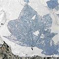
Fossil leaf of the sweet gum Liquidambar lievenii.

Fossil branch end of the cypress Taxodium dubium.
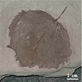
Fossil leaf of the poplar Populus crenata.
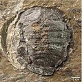
Pond turtle Clemmydopsis sp.

Fossil land snails Mesodontopsis nehringi.


As a result, the transport power of the rivers increased; at the same time, the main drainage shifted from the western edge to the center of the bay. There, in the area of the greatest peat thickness, the peat sank particularly under the load of the overlying sediments. Thus the regions of greatest brown coal thickness and greatest late Miocene sedimentation coincide. In the south of the bay a larger lignite seam was last created, the upper seam group from the Inden layers. Main rivers were the Rhine and the Meuse . In the Upper Miocene, a connection between the Upper and Lower Rhine was created, which created a drainage system from the Alps to the North Sea. For the first time gravel and large blocks from the entire Rhenish Slate Mountains reached the Lower Rhine Bay via the Rhine. These sediments belong to the main gravel series. A brief sea rise in the Pliocene allowed the North Sea to advance once more to the Lower Rhine . With this reduced hydraulic gradient, clays were deposited in the bay above the main gravel in a lake landscape, the red-tone series. Above it, in a moderate climate, followed the Reuver series.
quaternary
The glaciation of the Antarctic began in the Tertiary 12 million years ago . This worsening of the climate started with a significant delay in the northern hemisphere. It can be recognized by a leap in flora and fauna, which marks the boundary between the Tertiary (Pliocene) and the Quaternary (Pleistocene). The Pleistocene is characterized by a frequent change between cold and warm periods. During the cold periods, the sea level was around 100 m below the current level. Large parts of today's continental shelf fell dry. The river valleys had a high gradient. Their water flow was subject to strong seasonal fluctuations. The highest amounts of runoff occurred in spring when the snow melted and were able to move large amounts of sediment. These factors created an overgrown river system .
Upon entering the Lower Rhine Bay, the Rhine split into several main streams, which deposited large areas of coarse-clastic sediments in this basin. This is how the older and younger main terraces came into being in the Old Pleistocene . Subsidence movements continued. Above all, there were vertical misalignments of disturbances, horizontal movements have a significantly lower share. In the south of the bay, Quaternary sediments are vertically offset from one another by up to 80 m, in the north at the Viersener Sprung at Süchteln, subsidence of 40 m has been proven. About 800,000 years ago the uplift of the Rhenish Slate Mountains increased. In the Rhenish Massif, today's narrow valleys of the Rhine and its tributaries cut into the plateau valleys of the main terraces. The uplift of the Rhenish mass during the deposition of the main terraces (plateau valley stage) was 7 cm / ka and reached an uplift of 16.5 cm / ka during the subsequent narrow valley stage (beginning 800,000 years ago). This has resulted in an uplift of the Rhenish Slate Mountains of up to 132 m for the last 800,000 years alone. The Cologne and Krefeld plaice in the Lower Rhine Bay contributed to this uplift. This limited the deposit area of the Rhine to the basin east of the Ville.
With the beginning of the Saale Glaciation 240,000 years ago, the north of the Lower Rhine Bay came under ice cover. In the Drenthe stage of the Saale glacial period, the glaciers advanced from Scandinavia across the Münsterland Bay into the Nijmegen- Goch - Krefeld - Düsseldorf area. The glaciers left boulders in the form of terminal moraines and edged moraines , which today form the Lower Rhine ridge . The Hülser Berg belongs to the latter . The periglacial climate led to extensive permafrost that existed on the Lower Rhine until the end of the Vistula glaciation . In the cold ages, an aeolian dust sediment, the loess, was deposited on the plateaus remote from the river . Tundrengley formed on the loess in the interstadial . Parabroun earth was formed during the warm periods and sand loess at higher wind speeds. The loess on the Lower Rhine is 1–2 m thick on average. The loess sedimentation of the Vistula glacial period took place in three phases, interrupted by soil formation during two interstadials . The first two loess formations from the Vistula period fall into the early glacial period, the last and largest form into the high glacial period.
During the Young Pleistocene Glacial Vistula 127,000 to 10,500 years ago, the rivers cut into the older terrace bodies and graveled up the older and younger lower terraces. At the end of the Vistula glacial period, volcanic activity revived in the south of the Lower Rhine Bay. The volcanic ash of the volcano that erupted 11,000 years ago near Maria Laach can be identified as Laacher See Tephra in the Quaternary sediments as a guide horizon as far as southern Sweden, and thus allows the sediments to be precisely dated .
After the end of the Vistula glacial period, the Holocene (beginning 10,500 years ago) began a warm period . The river system in the preboreal and boreal showed both warm-time, meandering and cold-age, overgrown elements. A total of eight transgressions occurred from the Atlantic via the Subboreal to the recent section of the Holocene, the Subatlantic . Today's sea level was reached around 800 AD.
earthquake
The fracture tectonic subsidence of the Lower Rhine Bay continued in the Holocene to this day. Measurements on the Rur, Erft and Kölner Scholle showed subsidence of 1 to 2.5 mm / a for the period from 1933 to 1952. 10% of the tectonic movements in the Lower Rhine Bay take place in the form of earthquakes , about every four months with a magnitude of 2 on the Richter scale . The focal depths are between 6 and 18 km. The earthquake in Roermond , the worst earthquake in the Lower Rhine Bay since the earthquake near Düren in 1756 , occurred on April 13, 1992. It had its epicenter 4 km southwest of Roermond at a depth of 17 km at the Peel-Randbruch (German: Rur -Randsprung ) and was noticeable nationwide with a magnitude of 5.9.
Natural resources

Extraction of brown and hard coal in the Rhineland
Minable lignite is located in the south of the Lower Rhine Bay in the Rhenish lignite area , in a 4,000 km 2 triangle between Cologne, Aachen and Mönchengladbach. Lignite has been locally extracted there since the 17th century. Lignite has been mined industrially here in open-cast mining since the end of the 19th century. She received for the production of cheaper domestic energy and especially for energy-intensive chemical industry is becoming increasingly important. Today about 15% of the annual German electricity demand is covered by the Rhenish lignite . This is happening today in three opencast mines, the Garzweiler opencast mine , the Hambach opencast mine and the Inden opencast mine .
The extraction of hard coal from the subsoil of the Lower Rhine Bay initially took place on the edges of the subsidence area in the southwest of the bay. Coal mining in the Aachen area , in the Inde area and in the worm area has been known since the 14th century. As in the Ruhr area , extraction continued northward, with the overlap of the seam-bearing layers by younger layers increasing. This made mining uneconomical. Hard coal production ended with the closure of the Sophia-Jacoba colliery in 1997.
literature
- Josef Klostermann: The Quaternary of the Lower Rhine Bay , Geological Service NRW, Krefeld 1992, ISBN 978-3-86029-925-8 , 200 pp.
- Hans Dieter Hilden [Hrsg.]: Geologie am Niederrhein , Krefeld 1988, (Geological State Office). ISBN 3-86029-909-3 .
Individual evidence
- ↑ a b Walter, Roland et al .: Geology of Central Europe. 5th edition, Schweizerbarth'sche Verlagsbuchhandlung, Stuttgart 1992. ISBN 3-510-65149-9 , pp. 69ff
- ↑ The Lower Rhine Graben System (Roer Valley Graben) - Modern Seismicity ( Memento of the original from July 20, 2006 in the Internet Archive ) Info: The archive link was automatically inserted and not yet checked. Please check the original and archive link according to the instructions and then remove this notice. . Retrieved March 1, 2008.
- ↑ spiegel.de February 22, 2016: Interview with Christoph Grützner
- ↑ G. Drozdzewski et al .: Sedimentation and tectonics in the Paleozoic and Post-Paleozoic of the Lower Rhine Bay. - In: Advances in Geology Rheinld. u. Westf., Vol. 37, Krefeld 1998, pp. 573-583 (Geological State Office).
- ^ V. Wrede: Deep tectonics of the Aachen-Erkelenz coal area. - In: G. Drozdzewski u. a. [Ed.]: Contributions to the deep tectonics of West German coal deposits, Krefeld 1985, pp. 9-104 (Geological State Office)
- ^ W. Schlimm, A. Thiermann: The Permian of the Lower Rhine Bay. - In: HD Hilden [Ed.]: Geologie am Niederrhein , Krefeld 1988, pp. 18–23 (Geological State Office)
- ↑ R. Teichmüller: A cross section through the southern part of the Lower Rhine Zechstein Basin. - In: Geol. Jb., Vol. 73, Hannover 1958, pp. 39-50
- ↑ G. Knapp: The Triassic of the Lower Rhine Bay. - In: Hilden, HD [Ed.]: Geologie am Niederrhein , Krefeld 1988, pp. 23-27. ISBN 3-86029-909-3 .
- ^ W. Knauff: The Jura in the Lower Rhine Bay. - In: Hilden, HD [Ed.]: Geologie am Niederrhein , Krefeld 1988, pp. 27-28. ISBN 3-86029-909-3 .
- ↑ a b H.D. Hilden & A. Thiermann: The chalk of the Lower Rhine Bay. - In: Hilden, HD [Ed.]: Geologie am Niederrhein , Krefeld 1988, pp. 28-32. ISBN 3-86029-909-3 .
- ^ H. Hager & J. Prüfert: The Tertiary of the Lower Rhine Bay. - In: Hilden, HD [Ed.]: Geologie am Niederrhein , Krefeld 1988, pp. 32-40 (Geological State Office). ISBN 3-86029-909-3 .
- ↑ K. - F. Simon et al .: Deposits of the Tertiary. Pp. 139-166. - In: v. Koenigswald, W.; Simon, KF [Eds.] (2007): Georallye - Searching for traces of the history of the earth. Eifel, Bonn and the surrounding area. 367 p.: Ill., Graph. Darst., Kt .; Bouvier-Verlag, Bonn 2007. ISBN 978-3-416-03196-7 .
- ↑ J. Klostermann: The migration of the continents. Basics of plate tectonics and the recent stress on the Lower Rhine Bay from today's perspective. - Nature and landscape on the Lower Rhine, Vol. 10, Krefeld 1991, pp. 61-98.
- ↑ BU Haq, J. Hardenbol & PR Vail: Chronology of fluctuating sea levels since the Triassic . - Science, Vol. 235, Cambridge 1987, pp. 1156-1167.
- ^ V. Sonne: Were parts of the Rhenish Slate Mountains flooded by the sea in the Tertiary? - Mainz geoscientific. Mitteilungen, Vol. 11, Mainz 1982, pp. 217-219.
- ^ B. Buchardt: Oxygen isotope palaeotemperatures from the Tertiary period in the North Sea area. - Nature, Vol. 275 (5676), Basingstoke 1978, pp. 121-123.
- ^ J. Klostermann: The Quaternary of the Lower Rhine Bay. - Krefeld 1992, 200 pages (Geological State Office).
- ↑ W. Meyer & J. Stets: Young tectonics in the Rhenish Slate Mountains and their quantification. - Currently German geol. Ges., Stuttgart 1998, Vol. 149 (3), pp. 359-379.
- ^ EH Müller: Type and origin of the loess and soil formations in the aeolian deposits of North Rhine-Westphalia, taking into account the neighboring areas. - Progr. Geol. Rheinl. u. Westf., Krefeld 1959, Vol. 4, pp. 255-265.
- ↑ K. Brunnacker: The Lower Rhine in the Holocene. - Progr. Geol. Rheinl. u. Westf., Krefeld 1978, Vol. 28, pp. 399–440 (Geological State Office)
- ↑ J. Klostermann Quaternary - In: Hilden, HD [ed.]: Geologie am Niederrhein , Krefeld 1988, pp. 40-48 (Geological State Office). ISBN 3-86029-909-3 .
- ↑ J. Klostermann: Earthquake - causes and effects. - Geological map NRW 1: 100,000, explanations on sheet C 5102 Mönchengladbach, Krefeld 1990, pp. 75–78.
- ^ H. Grabert: Outline of the geology of North Rhine-Westphalia. - Stuttgart 1998, 351 pages (E. Schweizerbart'sche Verlagsbuchhandlung).
- ^ J. Klostermann, J. Kremers & R. Röder: Recent tectonic movements in the Lower Rhine Bay. - Progr. Geol. Rheinld. u. Westf., Krefeld 1998, Vol. 37, pp. 557-571.
Web links
- Geological Service NRW: Constantly updated list of the last earthquakes in the Lower Rhine Bay
- Oligocene basin dynamics and sequence stratigraphy on the southern edge of the northwest European tertiary basin (abstract of a dissertation (2003) with link to full text)
Coordinates: 51 ° 4 ′ N , 6 ° 37 ′ E