
Roermond
 flag |
 coat of arms |
| province |
|
| mayor | Rianne Donders-de Leest ( CDA ) |
| Seat of the municipality | Roermond |
|
Area - land - water |
71.05 km 2 60.84 km 2 10.21 km 2 |
| CBS code | 0957 |
| Residents | 58,202 (Jan 31, 2019) |
| Population density | 819 inhabitants / km 2 |
| Coordinates | 51 ° 11 ′ N , 5 ° 59 ′ E |
| Important traffic route |
|
| prefix | 0475 |
| Postcodes | 6041-6045, 6049, 6071 |
| Website | Roermond municipality |
 |
|
Roermond ([ ʁuːʁˈmɔnt ], ; Limburgish Remunj , French Ruremonde ) is a town and municipality with 58,202 inhabitants (as of January 31, 2019) in the Dutch province of Limburg . It lies on the border with Germany and near Belgium .
geography
location


The city is located at the confluence of the Rur (Dutch Roer ) in the Meuse on the right bank of the Meuse. The city center is located directly on the Rur. The municipal area essentially consists of the five kilometer wide strip between the Maas and the border with Germany.
Gravel removal has created numerous interconnected lakes in the municipality, the Maasplassen (German Maasseen or Maastümpel ). The approximately 3000 hectare area is the largest inland water sports area in the Netherlands.
geology
Roermond is located in the Cologne Bay earthquake area . Four kilometers southwest of the city was the on 13 April 1992 the epicenter of the earthquake of Roermond , an earthquake of magnitude 5.9 on the Richter scale . It was the strongest earthquake in Central Europe since 1756.
Districts
Roermond is divided into a total of 36 districts . At the beginning of 2007, the northern neighboring municipality of Swalmen with 8790 inhabitants was incorporated. The area of the municipality increased considerably through the incorporation from 46.87 to 71.19 km².
The ten city districts have the following population figures:
| district | year | ||
|---|---|---|---|
| 2006 | 2012 | 2018 | |
| Center | 9,010 | 9,360 | 10.160 |
| Roermond-Oost | 5,670 | 6.130 | 6,395 |
| Roermond-Zuid | 5,860 | 5,675 | 5,865 |
| Maasniel | 7,530 | 7,660 | 7,555 |
| Donderberg | 4,960 * | 4,765 * | 7,095 |
| Hoogvonderen | 6,120 * | 5,825 * | 3,360 |
| Asenray | 890 | 870 | 930 |
| Herten | 5,420 | 7,055 | 7,595 |
| Swalms | - | 8,670 | 8,660 |
| Maasplassen | - | 150 | 125 |
| total | 45,460 | 56,160 | 57,740 |
Neighboring communities
Surname
The city name Roermond suggests that the confluence (Dutch monding ) of the Rur ( Roer ) in the Meuse is meant (like Rijnmond ), but has a different origin, only because the confluence of the Rur in the Meuse 1338 several kilometers further west far from the city. The second syllable moon probably comes from the term “monte” for an elevation. What is meant is a castle hill, an old fortification, called Motte - Roermond therefore means "Rurburg". According to another reading, “moon” is derived from the Latin mundium - city, ie “city on the Rur” or “Rurbrücke” with Celtic-Germanic “monde” for “bridge”.


history
The urban origins go back to the Romans . An altar stone consecrated to the goddess Rura , which was found in the urban area, dates from the 3rd century AD. Caesar is said to have called the Roman place "Villa Optima", meaning "best place to live".
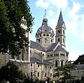
The oldest document that has survived to this day, in which Roermond is mentioned, dates from 1130; at that time it belonged to the Duchy of Geldern . In 1213 Roermond was destroyed by the German Emperor Otto IV . During the subsequent reconstruction work began in 1224 on the construction of the cathedral abbey , of which the Liebfrauen-Münsterkirche has been preserved to this day.
In 1232 Roermond received its own seal as well as the right to raise taxes and to exercise jurisdiction and in 1441 it became a Hanseatic city . The city received the right to mint coins in 1472. From 1338 to 1342 the course of the Meuse was artificially relocated by about seven kilometers to the city limits and with it the mouth of the Rur.
Nijmegen and the upper district of Geldern came under Spanish rule in 1543 through the Treaty of Venlo . In 1554 the first big city fire occurred. In 1559 the Diocese of Roermond was formed for the first time ; In 1801 (" French times ") it was temporarily dissolved until 1853. In 1665 there was the second big city fire.
From 1702 to 1716 Roermond was an independent state. It then belonged to the Austrian Netherlands until 1794 , with the city being conquered for the first time by the French under Francisco de Miranda in December 1792 . In March 1793 the Austrians initially retook Roermond before it was occupied by the French in April 1794, who renamed the city Rurmonde . The French occupation lasted until 1814 when it was liberated by Russian troops . The city was Dutch from 1815 to 1830, after which it was part of Belgium until 1839 . Up until 1866, East Limburg was part of the Netherlands and the German Confederation . The city has been exclusively Dutch again since 1866.
When the German Wehrmacht invaded the Netherlands ( May 10, 1940 ), Roermond was one of the few cities where military resistance was offered for a few days ( Slag om Roermond ). The Netherlands capitulated on May 15, 1940 . On December 29, 1944, around 3,000 men between the ages of 16 and 60 were deported from Roermond. They spent the night on the 30th in Dülken outdoors, on the 30th they were transported by train to Wuppertal and from there they were taken to various cities for forced labor. A memorial in the Nassaustraat in Roermond has been commemorating this since 1953. A few days earlier, on December 26th, 14 Roermond men between the ages of 16 and 48 had been driven by the Wehrmacht into the Elmpter Forest, where they had been forced to dig their own grave and were shot without judgment. The Lüsekamp memorial in the Elmpter Forest commemorates this war crime .

The Western Allies conquered the triangle of land between Roermond, Sittard and Heinsberg as part of Operation Blackcock (January 14-26 , 1945).
Since the loss of terrain as a result of Operation Blackcock , the Wehrmacht feared that their section of the front between Heinsberg and Venlo, the Maas-Rur position , which had been provisionally fortified since autumn 1944 , would be encompassed on both sides. Therefore they withdrew from this section of the front without a fight. Before fleeing on February 28, 1945, they blew up the tower of Christoffelkathedraal , the episcopal church of the Diocese of Roermond . On March 1, the Recce Troop (reconnaissance unit) of the 35th US Infantry Division ("Santa Fe Division") reached Roermond, which had already been abandoned by the Wehrmacht.
On April 13, 1992, the city was the epicenter of a 5.9 magnitude earthquake .
In 2001 an outlet center opened in Roermond . In 2013 it was visited by about 4.6 million people.
coat of arms
Blazon : “Divided by blue and silver, above a double-tailed, upright, red-tongued and armored, gold-crowned, golden lion, below a red heraldic lily. The shield is covered with a golden three-leaf crown, adorned with two pearls, three red diamond stones and two blue oval stones ”.
Explanation: The lion represents the "Geldrian lion", the heraldic animal of Geldern, in which the Roermondsche Land, known as Obergeldern or Oberquartier, has played a large part since the 13th century. The lily is taken from the coat of arms of the "van Wachtendonck" family ( a red lily in silver ; see also Wachtendonk with lily in the coat of arms), which several bailiffs in Roermond provided. A seal stamp from the 13th century has survived and shows the lily. The oldest surviving city seal of Roermond dates from 1250 and shows the coat of arms of the Dukes of Geldern.
Culture and sights
Attractions
- Liebfrauen-Münsterkirche (13th century). Inside, the magnificent grave of the founder, Count Gerhard IV. Von Geldern and his wife Margaretha von Brabant
- Cathedral of St. Christopher (15th century). Inside: Dalheimer Cross from the 13th century.
- Minderbroederskerk (15th century)
- Town hall from 1700 with a carillon tower
- Marinas
- Chapel In 't Zand (Zum Sand), Marian pilgrimage site
- late Gothic Begarden Chapel
- Resort Marina Oolderhuuske, floating houses on the Maassee Hatenboer (Zuidplas) with its own marina (port) , campsite and restaurant
politics
Distribution of seats in the municipal council
The municipal council has been formed as follows since 1982:
| Political party | Seats | |||||||||
|---|---|---|---|---|---|---|---|---|---|---|
| 1982 | 1986 | 1990 | 1994 | 1998 | 2002 | 2006 | 2010 | 2014 | 2018 | |
| Liberal People's Party Roermond |
- | - | - | - | - | - | - | - | 10 | 9 |
| GroenLinks | - | - | 3 | 4th | 4th | 3 | 2 | 2 | 4th | 7th |
| CDA | 9 | 8th | 9 | 7th | 5 | 7th | 5 | 5 | 5 | 5 |
| Democrats Swalmen | - | - | - | - | - | - | 3 | 2 | 3 | 3 |
| VVD | 5 | 4th | 4th | 5 | 7th | 10 | 9 | 11 | 3 | 2 |
| D66 | 0 | - | 1 | 1 | 1 | 1 | 0 | 1 | 2 | 2 |
| SP | - | - | - | - | - | - | 3 | 2 | - | 1 |
| City party Roermond | - | - | - | - | - | - | 1 | 1 | 1 | 1 |
| THINK | - | - | - | - | - | - | - | - | - | 1 |
| PvdA | 3 | 7th | 4th | 4th | 4th | 4th | 5 | 4th | 3 | 0 |
| Roermond burger issues | - | - | - | - | - | 3 | 3 | 2 | 0 | - |
| Partij Voor De Eenheid | - | - | - | - | - | - | - | 1 | 0 | - |
| Liberals '97 | - | - | - | - | 0 | 1 | - | - | - | - |
| Democrats Maasniel, Asenray, Leeuwen a |
3 | 3 | 3 | 3 | 3 | - | - | - | - | - |
| Democrats Roermond a | - | - | 3 | 2 | 2 | - | - | - | - | - |
| Algemeen Ouderen Verbond / Unie55 + |
- | - | - | - | 1 | - | - | - | - | - |
| Center Democrats | - | - | - | 1 | - | - | - | - | - | - |
| Democrats Roermond Veld, Kapel, Kemp, Kitskensberg |
1 | 1 | - | - | - | - | - | - | - | - |
| Roermond Links b | 1 | 1 | - | - | - | - | - | - | - | - |
| Raad '70 | 2 | 1 | - | - | - | - | - | - | - | - |
| Donderberg / Hoogvonderen c |
1 | - | - | - | - | - | - | - | - | - |
| total | 25th | 25th | 27 | 27 | 27 | 29 | 31 | 31 | 31 | 31 |
- ↑ Parties that took part in the election but were unable to obtain a seat on the council will not be considered.
College of Mayors and Aldermen
The coalition parties CDA , D66 , Democrats Swalmen and GroenLinks will provide the council with the councilors for the period from 2018 to 2022. With the exception of GroenLinks, all parties each contribute one councilor, while those parties are present with two councilors. The following people belong to the college and are responsible in the following areas:
| function | Surname | Political party | Department | annotation |
|---|---|---|---|---|
| Mayoress | Rianne Donders-de Leest | CDA | public order and administrative matters; integral security / integral enforcement; Complaints settlement; Population affairs, person registration and elections; administrative and (EU) regional cooperation; Representation and external relationships; Dualism; integrity | in office since January 30, 2015 |
| Alderman | Angely Waajen Crins | CDA | economic affairs and job opportunities; Labor market policy (employer); Spatial planning; Housing; Environment concept; Alderman for the N280 and vital city projects | - |
| Marianne Smitsmans-Burhenne | GroenLinks | social welfare; Social affairs; Public health; Communication; Citizen participation; social affairs; Labor market policy (employees) | deputy mayor | |
| Ren Evers | GroenLinks | Sustainability; public space and urban management; Mobility and infrastructure; green environment and raw materials; Nature, landscape and water; District development and district targeted work; Environmental law (implementation); Environmental permits; Alderman for the train station environment project | - | |
| Frans Schreurs | Democrats Swalmen | Finance; Fundamental and Ownership; legal affairs and quality management; Personnel, organization and information supply; Sports and sports facilities | - | |
| Ferdinand Pleyte | D66 | Education and parenting; Culture; Diversity; Monuments, heritage and archeology; Alderman for the development plan project for the Donderberg district | - | |
| Community Secretary | Han Geraedts | - | - | in office since October 2011 |
gallery

Tower (de Natalinitoren) and Cathedral (de Sint-Christoffelkathedraal)

Munsterkerk
Munsterkerk

Minderbroederskerk

Minderbroederskerk, view of the vault that was renovated after the 1992 earthquake

St. Christopher's Cathedral
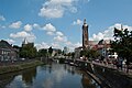
View of the Rur just before it flows into the Meuse with the Rurhafen and St. Christophorus Cathedral on the right in the background
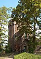
Defense tower next to the cathedral


Museums
- Municipal Museum
Regular events
The city of Roermond awards the Halewijn Prize for literature every year .
economy
Roermond is a shopping city for visitors from the Netherlands and Germany. In 2001, a large shopping center called McArthurGlen Designer Outlet Roermond was built in the immediate vicinity of the city center on an abandoned barracks site . The shopping center has over 150 shops and is visited by around 2.8 million visitors annually. Contrary to original fears, around 40% of them also visit the Roermond city center, which has since experienced a considerable boom. Due to the attraction of the outlet center , Roermond is about to overtake the much larger Venlo among German visitors. Especially geared towards German visitors, all Sundays in downtown Roermond are open for sale, the outlet center is open 363 days a year.
Roermond is the seat of Peek & Cloppenburg Düsseldorf Komplementär BV
traffic
Rail transport
Roermond has a train station in the city center. The city is on the main Maastricht - Eindhoven railway line , with intercity trains running to Amsterdam . In addition, a local railway line begins in Roermond along the Maas to Venlo and over the Maas line to Nijmegen .
The Iron Rhine railway line from Antwerp to Mönchengladbach also runs through Roermond . The line is currently out of service on the 16.5 kilometers between Roermond and Dalheim on the German-Dutch border. There are plans to reactivate them for freight traffic, but there is considerable opposition.
Shipping

Tourist shipping uses (as of 2011) the mouth of the Rur with its old Looskade (loading quay). Here visitors with boats up to 8 mtr. Length of a "pier" laid out on both sides of the Rur z. B. for a visit to Roermond, but staying overnight is not allowed. The Rur is here max. 30 m wide, but often occupied by boats on both sides. The length of the boat had to be limited because otherwise turning in the narrow and flowing river arm of longer boats would be impossible or only possible with considerable danger.
The former freight port nieuwe Maashaven , built around 1935, is located on the Maas . Its basin is now part of the actual cargo or industrial port, which was built from 1963 to 1967 and named Prince Willem Alexander Haven by the royal family . In the Regional Overslag Centrum Roermond (ROC), part of the Willem Alexander industrial harbor, more than 500,000 tonnes of bulk and general cargo are transshipped between trucks and barges on an area of 2 hectares with a 400 m quay. Around the port, in the industrial area of the same name, more than 1000 people are employed.
The Haven la Bonne Aventure on the Maas is currently used for pleasure boating.
The shipping companies Rederij Cascade , Rederij de Corporaal and Rederij De Veermann regularly visit Roermond with their excursion boats (as of 2011).


Bus routes
A number of city and country buses connect both the districts and neighboring towns to the Roermond train station. Since April 2008, the city has also set up “shop buses” which, as shuttle buses, connect the city center with the outlet center and the newly built retail center.
Bike paths
Roermond has an extensive network of cycle paths in and out of town.
Road traffic
Roermond has been directly connected to the Dutch motorway network since the beginning of 2008. The Rijksweg 73 (A 73) runs along the Maas of Nijmegen over Venlo and Roermond to Maasbracht . From there, Rijksweg 2 (A 2) extends the route further to Maastricht and Liège .
The motorway connection to the German federal motorway 52 to Mönchengladbach and Düsseldorf was released on May 18, 2009 between the Dutch border and Elmpt . On the Dutch side, the N 280 has already been completed like a motorway to the border.
The N 280 connects to Weert to the west and the A 2 in the direction of Eindhoven . The N 271, which corresponds to a German federal highway, runs roughly parallel to the A 73 and now mainly serves local traffic.
Flood protection


The exposed location of the city on the Rur and Maas is the cause of frequent floods after prolonged rain and snowmelt in the Eifel and the Ardennes. The water board Waterschap Roer en Overmaas has installed flood protection gates in the Rur since 2008 to protect Roermond from flooding, which if necessary (for the first time in January 2011) diverts the Rur in the city center via the Hambeek. They also seal off the Meuse water from the city.
Personalities
Sons and daughters of the place
- Johannes Murmellius (around 1480–1517), pedagogue, philologist, poet and humanist
- Hendrick Heuck (around 1600–1677), inventor of the yaw ferry
- Whale wheel of Nassau-Usingen (1635–1702), Prince of Nassau-Usingen and imperial general
- Jan Frans van Douven (1656–1727 in Düsseldorf), portrait painter
- Johann Christoph Manskirsch (1689–1760), sculptor
- Philipp Damian von Hoensbroech (1724-1793); Canon in the Principality of Speyer , Bishop of Roermond
- Pierre Cuypers (1827–1921), architect, arts and crafts entrepreneur
- Henry Luyten (1859–1945), painter
- Henri Leeuw Jr. (1861–1918), painter and sculptor
- Joseph Cuypers (1861–1949), architect
- Johannes Ludovicus Mathieu Lauweriks (1864–1932), architect
- Oscar Leeuw (1866–1944), architect
- Ludwig Maringer (1867–1938), merchant and spy
- Louis Raemaekers (1869–1956), caricaturist
- Charles Ruijs de Beerenbrouck (1873–1936), Dutch Minister of the Interior and Prime Minister
- Frederik van Iterson (1877–1957), civil engineer
- Richard Schoemaker (1886–1942), saber fencer, university professor and resistance fighter
- Miel Campioni (1901–1962), football player
- Louis Beel (1902–1977), politician and Prime Minister
- Unica Bachmann-Calcoen (1904–1986), portrait and animal painter
- Jo Cals (1914–1971), politician and Prime Minister
- Louis Motké (1918–1988), racing cyclist
- Piet Schoenmakers (1919–2009), artist
- Lei Derichs (1922–2010), athlete
- Joep Bertrams (* 1946), cartoonist
- Marleen Gorris (* 1948), screenwriter and film director
- Wim Vrijhoef (* 1952), politician
- Tof Thissen (* 1957), politician
- René Janssen (* 1959), materials scientist and university professor
- Bernardus Manders (born 1962), actor
- Theo Meuwissen (* 1963), bioinformatician and animal breeder
- Roger Reijners (* 1964), football player
- Annemarie Cox (* 1966), canoeist
- Machiel van Frankenhuijsen (* 1967), mathematician
- Nelleke Beltjens (* 1974), sculptor and draftsman
- Rogier Wassen (* 1976), tennis player
Personalities who have worked on site
- Gerhard IV. (* Around 1185; † October 22, 1229), Count of Geldern
- Dionysius of Roermond (* 1402/03 in Rijkel; † March 12, 1471 in Roermond), philosopher, theologian, mystic and scholastic
Town twinning
-
 Koszalin , Poland
-
 Marktredwitz , Germany ; since 2007; before that partner community of Swalmen
 -
Mönchengladbach , Germany; since 1971
-
 Nepomuk , Czech Republic ; since 2007; before that partner community of Swalmen
 -
 Vinkovci , Croatia
See also
Web links
- Website of the municipality of Roermond (Dutch, German, English, French)
Individual evidence
- ↑ Bevolkingsontwikkeling; regio per maand . In: StatLine . Centraal Bureau voor de Statistiek (Dutch)
- ↑ see also Dutch Wikipedia
- ↑ Britta Marzi: What war means for children. In: Rheinische Post . October 13, 2012, accessed October 21, 2012 .
- ^ Report in the Westdeutsche Zeitung of January 2, 2009, accessed on September 21, 2013
- ↑ Report on Operation 'Blaclcock' (PDF; 5.2 MB)
- ↑ www.kathedraal-roermond.nl (click on 'History')
- ↑ http://www.outlet-center-info.de/news_erverbindlicher-jahresverbindungen-2013-fur-das-designer-outlet-roermond.html Report on Outlet-Center-Info.de, accessed on April 21, 2014
- ↑ Result of the local elections: 2014 2018 , accessed on August 24, 2018 (Dutch)
- ↑ Allocation of seats in the municipal council: 1982–2006 2010 2014 2018 , accessed on August 24, 2018 (Dutch)
- ^ College van B & W Gemeente Roermond, accessed on August 24, 2018 (Dutch)
- ↑ http://www.kallebakker.nl/
Beek | Beekdaelen | Beesel | Mountains | Brunssum | Echt-Susteren | Eijsden-Margraten | Gennep | Gulpen-Wittem | Heerlen | Horst aan de Maas | Kerkrade | Landgraaf | Leudal | Maasgouw | Maastricht | Meerssen | Mook en Middelaar | Nederweert | Peel en Maas | Roerdalen | Roermond | Simpelveld | Sittard Geleen | Stone | Vaals | Valkenburg aan de Geul | Venlo | Venray | Voerendaal | Weert