Voerendaal
 flag |
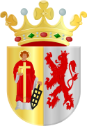
 coat of arms |
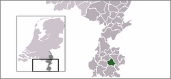
| province |
|
| mayor | Wil Houben ( VVD ) |
| Seat of the municipality | Voerendaal |
|
Area - land - water |
31.52 km 2 31.51 km 2 0.01 km 2 |
| CBS code | 0986 |
| Residents | 12,442 (Jan 31, 2019) |
| Population density | 395 inhabitants / km 2 |
| Coordinates | 50 ° 53 ' N , 5 ° 55' E |
| Important traffic route |
|
| prefix | 045 |
| Postcodes | 6311-6312, 6343, 6367 |
| Website | Homepage of Voerendaal |
Voerendaal ( ) is a place and a municipality in the Dutch province of Limburg . It is a member of the Parkstad urban agglomeration .
language
In addition to the official language Dutch , the local population mostly speaks Limburgish . The highest windmill in the municipality is located on the 216 meter high Vrouwenheide .
History and origin
Voerendaal is in the hilly landscape between Heerlen, Simpelveld, Wittem, Gulpen, Valkenburg and Nuth. The community consists of five main villages. Voerendaal was already inhabited in Roman times. Remains testify to a bath house, a temple and a pond from that time. The foundations of a Roman villa have been found near the “Ten Hove” (“Zum Hof”) farm.
On January 1, 2008 Voerendaal had 12,757 inhabitants, who were distributed as follows:
- Peter 2975
- 3305
- Kunrade 3670
- Dublin 1577
- Ransdaal 996
- Smaller districts 234
Districts
- Barrier
- Colmont
- Craubeek
- Dolberg
- Eyserheide
- Fromberg
- Heek
- Hellebeuk
- Climbing
- Koulen
- Kunrade
- Mingersberg
- Opscheumer
- Overheek
- Ransdaal
- Retersbeek
- Termaar
- Termoors
- Ubachsberg
- Weustenrade
- Winthagen
The municipal flag
In the resolution of February 20, 1995, the municipal council set a new municipal flag.
Description of the flag
The starting point for the new flag is the name Voerendaal. The name "Voerendaal" consists of a combination of the words "Voeren" and "Daal". The word "Voeren" denotes a shoal or ford and can be traced back to the Frisian word " Forda ". The word "Daal" means " valley ".
The chosen design consists of five strips that are divided in a ratio of 1: 1: 2: 1: 1. Two blue brooks flow through the yellow valley, the three French lilies are an element that can be traced back to the historical legacy of the municipality of Klimmen, which until 968 was the property of the French queen Gerberga.
The crest
Voerendaal belonged to Heerlen until 1777, except for seven years when it was owned by Willen van Cortenbach. From 1777 Voerendaal had its own council.
Because Heerlen, and thus Voerendaal, was one of the main aldermen's chairs in Valkenburg, the Valkenburg lion can be seen in the coat of arms. The person pictured is Saint Lawrence, a church patron.
The community at that time applied for the mirrored coat of arms in the first application, but the high council of the nobility placed the saint in the first field, the place of honor, and rejected the application.
The community logo
The municipal coat of arms was used until 1991 for the stationery of the old municipality of Voerendaal. From January 1, 1992, the new logo was set, which is now used for all community documents. The logo can be seen in the top left of the official website of the municipality of Voerendaal. The “V” in the logo stands for Voerendaal; the four large windows symbolize the four largest villages (Ransdaal, Kunrade, Klimmen, Ubachsberg).
politics
Distribution of seats in the municipal council
The municipal council has been formed as follows since 1981:
| Political party | Seats | |||||||||
|---|---|---|---|---|---|---|---|---|---|---|
| 1981 a | 1986 | 1990 | 1994 | 1998 | 2002 | 2006 | 2010 | 2014 | 2018 | |
| Democrats Voerendaal b | 3 | 2 | 1 | 3 | 2 | 2 | 2 | 4th | 4th | 5 |
| Voerendaal Actief | - | - | - | - | - | - | - | 2 | 4th | 3 |
| CDA | 5 | 3 | 5 | 4th | 3 | 4th | 4th | 3 | 2 | 2 |
| PvdA | 0 | 3 | 3 | 2 | 3 | 2 | 3 | 2 | 2 | 2 |
| VVD | 2 | 2 | 1 | 1 | 1 | 1 | 1 | 1 | 0 | 1 |
| D66 | 0 | - | - | 2 | 3 | 3 | 2 | 2 | 2 | 1 |
| Algemeen Gemeenschapsbelang Voerendaal | 2 | 2 | 2 | 3 | 3 | 2 | 2 | 1 | 1 | 1 |
| Leefbaar Voerendaal | - | - | - | - | - | 1 | 1 | 0 | - | - |
| Politieke Groepering Ransdaal c | - | 2 | 2 | - | - | - | - | - | - | - |
| Lijst Moonen | 1 | 1 | 1 | - | - | - | - | - | - | - |
| Lijst Scheijen | 0 | 0 | - | - | - | - | - | - | - | - |
| Lijst Winthagen | 2 | - | - | - | - | - | - | - | - | - |
| PPR | 0 | - | - | - | - | - | - | - | - | - |
| Lijst angels | 0 | - | - | - | - | - | - | - | - | - |
| total | 15th | 15th | 15th | 15th | 15th | 15th | 15th | 15th | 15th | 15th |
- Remarks
College of Mayors and Aldermen
The following people belong to the college :
- mayor
- Wil Houben ( VVD ; took office: December 1, 2014)
- Alderman
- Ruud Braun (Democrats Voerendaal)
- Harry Coenen (Democrats Voerendaal)
- Peter Thomas ( CDA )
- Pierre Verbraak ( PvdA )
- Community Secretary
- Bert Timmermans
Web links
- Website of the municipality (Dutch)
Individual evidence
- ↑ Bevolkingsontwikkeling; regio per maand . In: StatLine . Centraal Bureau voor de Statistiek (Dutch)
- ↑ Result of the local elections: 2014 2018 , accessed on September 2, 2018 (Dutch)
- ↑ Allocation of seats in the municipal council: 1981–2002 2006 2010 2014 2018 , accessed on September 2, 2018 (Dutch)
- ↑ Samenstelling B&W Gemeente Voerendaal, accessed on September 2, 2018 (Dutch)


