Herten (Netherlands)
 flag |
 coat of arms |
| province |
|
| local community |
|
|
Area - land - water |
4.09 km 2 3.84 km 2 0.25 km 2 |
| Residents | 7,595 (Jan 1, 2018) |
| Coordinates | 51 ° 11 ′ N , 5 ° 58 ′ E |
| height | 20 m NAP |
| Important traffic route |
|
| prefix | 0475 |
| Postcodes | 6041, 6049 |
| Location of Herten in the municipality of Roermond | |
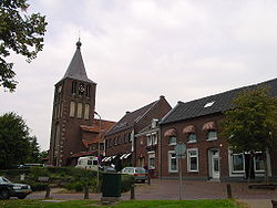
| Center of Herten | |
Herten ( Limburgish Herte ) is a place and a formerly independent municipality that was incorporated into the city of Roermond on January 1, 1991 .
Together with Swalmen , Asenray , Leeuwen , Maasniel , Ool and Roermond, Herten forms the city of Roermond.
The Roermond radio and television tower is in Herten.
history
In pre-Christian times there was a cult place of the Thor in Herten, which the Donderberg reminds of to this day.
Herten belonged to the Oberquartier Obergeldern and was successively Spanish , Austrian and Belgian . In the French period it belonged to the Belgian department of Nedermaas .
In 1968 the village celebrated its millennium.
Facilities
Herten has a parish church dedicated to St. Michael . The church was built in 1954 based on a design by the architect HW Valk. It had numerous previous buildings that were mainly destroyed by war.
Herten also has a Catholic and a public primary school, a supermarket, shops (including a bakery and a mezzanine), a sports hall, a bank and a marina. The SHH football club also comes from Herten.
Oolderveste
The Oolderveste residential area was created near Herten. It consists of 875 apartments built by 2010. It is divided into the four sub-areas Het Ommeland, De Veste, Bos en Lommer and Wonen aan het water.
There were protests from residents from Herten and Merum for years against the construction of the residential area . The residents feared that the village infrastructure would be overloaded.
politics
Distribution of seats in the municipal council
Until the municipality was dissolved, the following distribution of seats had been made since 1982:
| Political party | Seats | |
|---|---|---|
| 1982 | 1986 | |
| CDA | 3 | 4th |
| Lijst Dolmans | 3 | 3 |
| Progressive accord | 2 | 2 |
| VVD | - | 2 |
| Herten's concern | 2 | - |
| Lijst De Jong | 1 | - |
| total | 11 | 11 |
Web links
Individual evidence
- ↑ Kerncijfers wijken en buurten 2018 Centraal Bureau voor de Statistiek , accessed on August 25, 2018 (Dutch)
- ↑ Parochiekerk ( Memento of the original from August 8, 2006 in the Internet Archive ) Info: The archive link was inserted automatically and has not yet been checked. Please check the original and archive link according to the instructions and then remove this notice. parochie-herten.nl
- ↑ Allocation of seats in the municipal council , accessed on August 25, 2018 (Dutch)

