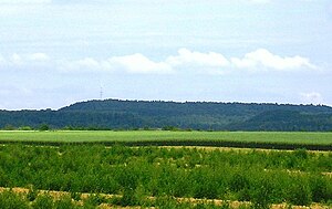
Glessener height
| Glessener height
(Glessener Kippe)
|
||
|---|---|---|
|
View from the south to Glessener Höhe |
||
| height | 205.8 m above sea level NHN | |
| location | near Glessen ; Rhein-Erft-Kreis , North Rhine-Westphalia ( Germany ) | |
| Mountains | Ville | |
| Coordinates | 50 ° 57 '17 " N , 6 ° 43' 35" E | |
|
|
||
| Type | Recultivated waste dump | |
| particularities | Highest elevation of Villerücken and Rhein-Erft-Kreis | |
|
The Glessener Höhe in the Rhenish lignite district |
||
The Glessener Höhe (also called Glessener Kippe ) near Glessen in the Rhein-Erft district , North Rhine-Westphalia , is a recultivated and 205.8 m above sea level. NHN high spoil dump ( dump ) of the surrounding lignite opencast mines in the Rhenish lignite mining area .
The artificially constructed hill forms the highest elevation of Ville rücken ( Die Ville ) and Rhein-Erft-Kreis. By nature - before the dump was created - the Villerücken rose at this point to a maximum height of 130 m .
geography
location
The Glessener Höhe is located in the area of the town of Bergheim , about 2.2 km southwest of the village church of its district Glessen . In the east, it borders on the state forest of Ville , which like the Kippe is part of the Rhineland Nature Park . To the northwest of the hill is the Abtsbusch forest area near Oberaussem , beyond the crossing north-south railway of RWE Power , and to the southwest is the Fischbachhöhe . Northeast of the current flowing through Glessen and also in the upper reaches springs Glessen Bach called Pulheimer Bach .
Natural allocation
The Glessener Höhe belongs to the natural spatial main unit group Niederrheinische Bucht (55), in the main unit Ville (552) and in the subunit Villehöhe (552.1) to the natural area Brown Coal-Ville (552.10).
Protected areas
To the east of the Glessener Höhe is the Glessener Bach headwaters nature reserve ( CDDA no. 165063; designated in 1986; 19 hectares in size) and to the south-east is the NSG Königsdorfer Forst (CDDA no. 164182; 1989; 3.28 km² ) with its fauna and flora Habitat area Königsdorfer Forst (FFH no. 5006-301; 3.29 km²). The hill is located in the conservation area Königendorfer Forest (CDDA No. 322241;. 1990; 13.23 square kilometers).
Description and free time
The Glessener Höhe was built between 1955 and 1970. The largely unwooded high plateau is used for agriculture, the slopes are reforested with mixed forest . There are many hiking, cycling and riding trails on the elevation, which are indicated on several information boards there.
At the easternmost point of the plateau, which is about 260 m southeast of the Kippen summit, there is a mountain cross, first erected in 1987 and rebuilt in 1999 : On a concrete base with the inscription "Glessener Höhe" - "204 m" it is an impregnated, simple wooden cross with an inscription "1987" - "New" - "1999" executed. There are wooden benches next to it, which invite you to linger on the south-east flank after a short but steep climb ( called the heavenly ladder ). From there, a wide open panoramic - attention from Duesseldorf TV tower over the Cologne basin , especially the cityscape of Cologne , in the background the Bergisch land then, south Siebengebirge with Drachenfels , Petersberg and Big Mount of Olives .
At the northwesternmost point of the plateau is a transmission tower . From the vantage point there (at a height of approx. 204 m ) you can see the Sophienhöhe and, with sufficient visibility, the Eifel .
Individual evidence
- ↑ a b Topographical Information Management, Cologne District Government, Department GEObasis NRW ( Notes )
- ↑ Map services of the Federal Agency for Nature Conservation ( information )
- ^ Achim Schumacher et al .: Recultivation in the Rhenish lignite mining area. Excursion guide. Part II (The opencast mining areas: history and recultivation) . Recultivation Research Center, Jüchen 2011 ( full text as PDF ).


