
Pulheim Bach
|
Pulheimer Bach upper course: Glessener Bach |
||
 End of the Pulheimer Bach in the Große Laache |
||
| Data | ||
| Water code | DE : 27373232 | |
| location | North Rhine-Westphalia , Germany | |
| River system | Rhine | |
| Drain over | Rhine → North Sea | |
| source | Below the Glessener Höhe on the eastern slope of the Ville ( Rhineland Nature Park ) 50 ° 57 ′ 44 ″ N , 6 ° 44 ′ 27 ″ E |
|
| Source height | 93 m above sea level NN | |
| Infiltration | At the Pletschmühle the water flows into the Große Laache and seeps from there to the Rhine Coordinates: 50 ° 59 ′ 45 ″ N , 6 ° 49 ′ 35 ″ E 50 ° 59 ′ 45 ″ N , 6 ° 49 ′ 35 ″ E |
|
| Mouth height | 43 m above sea level NN | |
| Height difference | 50 m | |
| Bottom slope | 6.4 ‰ | |
| length | 7.8 km | |
| Catchment area | 17.735 km² | |
The Pulheimer Bach , the brook system around the city of Pulheim in the north-west of Cologne , is a special example of environmental planning and nature conservation in the vicinity of a large city due to its almost complete renaturation as part of the Regio Grün action plan within the Regionale 2010 Cologne / Bonn.
Stream
The stream rises below the Glessener Höhe on the eastern slope of the Ville (in the Rhineland Nature Park ) at a height of about 100 m with several sources in the Liebesallee nature reserve at Gut Neuhof, Bergheim-Glessen . In the Neuhof and Broichhof area, it is dammed in several former mill ponds. On its short course of 8 km it flows through or touches the Pulheim districts of Sinthern , Geyen and the southern parts of the central town. Immediately behind it, in front of the Pletschmühle, the Cologne Rand Canal is crossed. Finally it seeps south-east of Orr in the Große Laache on the edge of the lower middle terrace at a height of 45 m. There are low-terraced gravel accumulated in the Vistula glaciation from an old loop of the Rhine and the nature reserve (since 1999) of the Kleiner and Großer Laache. Averaged over the year, around 50 to 60 liters per second flow at the Pletschmühle, which is almost two million m³ of water annually. From there the water trickles down to the Rhine. About 3 km away, the Weiler waterworks extract a large part of the drinking water for north-western Cologne. The entire catchment area of the stream with its ditches and tributaries is 24 km.
Former mill locations

There are no more watermills on the Pulheimer Bach, most of them were shut down in the 19th or first half of the 20th century, the last around 1960.
- Braunsfeldsmühle in Glessen near Gut Neuhof (the estate belonged to Count von Braunsfeld in the middle of the 18th century) with two grinding courses and an overshot water wheel . Two of three mill ponds are still there. The mill is mentioned for the first time in 1312 and was in operation until 1960.
- Abtsmühle 1250 m downstream between Glessen and Sinthern at the confluence of the Abtsmühlgraben, overshot. A mill already existed here before 1656, when the abbot of Brauweiler Abbey , who had acquired the nearby farm, renewed the mill. It burned down in 1886 after being struck by lightning. Some millstones can still be seen at the Abtshof near the Glessen church.
- Olligsmühle, 500 m downhill, shortly after the mouth of the also renatured Keuschenbroichgraben, around 1500 to the second half of the 19th century, a peeling and an oil gallery, on level terrain, therefore undershot. The mill house still exists and is used as a residential building, the pond is now an orchard. The millstones of the pan mill lean against the house.
- Sintered mill, another 750 m down, existed with two grinding cycles from about 1500 to 1930/40. In the end it was only crushed . She was standing on a small bend in the terrain and was therefore overshot. The pond was converted into an open-air swimming pool in 1937/38, but it did not significantly survive the Nazi era . It is still recorded on the topographic map from 1958.
- Geyener Mühle (Woltersmühle) from before 962 to around 1950, a grinding process in the "Mühlengrund" on the edge of the terrain, therefore overshot. The document of December 25, 962, which Archbishop Bruno of Cologne had issued for the St. Cäcilienstift in Cologne , names a mill in Geyen. Whether it was at its current location has not yet been investigated. The mill pond is now a sports field. The mill house with still existing millstones dates from the year 1900. It is to be rebuilt in accordance with a listed building from 2016 and put into residential use.
- Pulheimer Mühle, 2.25 km downhill on the western former edge of Pulheim in flat terrain and therefore undershot. Income from it was transferred in 1301 by Count Walram von Jülich , Herr von Bergheim, to the St. Georg-Stift in Cologne as reparation for a mill that he had destroyed. A street sign "To the old watermill" still reminds of this mill that was abandoned in 1930.
- Pletschmühle, 1500 m on the edge of the terrain, the impact slope of the former loop of the Rhine with the large and small laache, therefore overshot with a painting gallery and two ponds. It existed from the 13th century to 1930. The buildings now serve as a riding stables. Originally the mill was owned by the church and was therefore secularized during the French period . The Mühlenhof with 110 acres of land was raised in 1842 by the “highest cabinet order” of King Friedrich Wilhelm IV. To the state manor House Orr with war yard, Bayershof and Altenhof.
Water castles and courtyards

The Neuenhof near the springs was originally surrounded by moats, of which only small traces can be found in the area. The best preserved moated castle on the brook is the Junkersburg . Today the moat only extends from the medieval round tower to the baroque tower . But there is also a former water-enclosed courtyard in Sinthern. The Fronhof, which has been part of the Brauweiler Abbey, founded in 1024 since 1028, is one of the so-called court festivals because of its fortified structure with (only partially preserved) moat and castle-like entrance gate. Many of the courtyards connected to the mills will also have been reinforced with trenches.
Renaturation

Since the Pulheimer Bach seems important for the drinking water supply of Cologne, considerations were necessary to increase the water quality of the brook. The renaturation of sections of the stream began before 2005 when construction work on the stream made it possible. For longer distances, more capital and initiative were needed. On October 12, 2006, the Pulheimer Bach entertainment association applied for funding for the “Pulheimer Bach water axis” as an A project as part of the REGIOGRÜN campaign of the Regionale 2010 . The project should be included in the north-western green corridor from the old Rhine to the new energies on the Villehöhe. The Große Laache nature reserve and the Pulheimer See in the Stöckheimer Höfe local recreation area, which the cities of Pulheim and Cologne will expand over the next few years, are located in this green corridor at the end of the stream. The brook should, wherever possible, be renatured and designed as an "adventure and educational trail". After attaining the A qualification in June 2007, the groundbreaking ceremony for the renaturation of the creek took place on December 3, 2007, the first section was completed in the following summer and inaugurated by Jürgen Rüttgers , then Prime Minister and citizen of Pulheim . The funding decision for the state funds of 154,891 € came on September 3, 2008 by the district president Hans Peter Lindlar and was celebrated accordingly in the trench master's office of the association. The cities of Bergheim and Pulheim share the € 200,000 missing sum. The second section was started in 2009, the third in February 2010. The concrete pipes and floors were torn out and replaced with a gravel bed. Terrain steps and stepped junctions were given a basalt underlay to destroy energy. The banks were accompanied and fortified by tree planting and suitable woody plants such as black alder and aquatic plants such as red butterbur , blue rush , water lilies and reeds . In October 2009 the first noble crabs were put into the stream. In 2010 and 2011 a further tranche followed with over 1000 young animals from an Eifel breeding station. In 2013 it was successful because more than a dozen crabs of different ages and sizes were found during a check on a seven-meter-long section. The kingfisher is also at home in nesting caves in the bank walls. Considerations are underway to design the non-renaturable sections of the stream in the city districts as open channels. In March 2011, 8 of the 11 sections were renatured. The sections that are still piped in the places are marked by blue concrete blocks with white double waves, the symbol of the brook association, which were inserted into the route at a distance of about 10 m.
In December 2012, the district government received a further grant notification of over € 400,000 for the Sinthern, Martinstrasse, and Jakob-Pohl-Platz, Geyen section, which was tackled in the spring. At the beginning of the summer holidays, 500 meters were renatured and in 2013 the remaining 300 meters were completed.
Flood protection
The opening of the stream also creates space for heavy rain floods. Even before the work was completed, it was shown that the additional storage space of around 7,000 m³ gained by the renaturation represents a gain for the protection of the Pulheim site before the Bendacker flood retention basin with its storage volume of 28,000 m³ is used.
Cooperations
The Institute of Geography at the University of Cologne was won over to provide scientific support for the project . The private lecturer Reinhard Zeese from Brühl is in charge . After the relevant preparatory work, a sponsorship agreement was signed between those involved and the Faculty of Mathematics and Natural Sciences in the Institute of Geography on November 10, 2008.
The schools (eight by June 2011) and five kindergartens in the adjacent districts are very interested in dealing with the nature of the stream with events such as the green classroom . These are, for example, the Sinthern / Geyen community elementary school, which was recognized for its project by the Association of German Water Protection in a nationwide student competition in 2009 and 2010 (a third time in 2011), the Wolfhelm School community elementary school in Dansweiler , the Rochus school in Glessen , the Barbara school, the Marion -Dönhoff-Realschule and the Geschwister-Scholl-Gymnasium in Pulheim (award 2009). Even the schools from Brauweiler, Abtei-Gymnasium and Arthur-Koepchen-Realschule , which are not connected to the brook, participate. At the Didacta 2010 trade fair in Cologne, “The Green Classroom Pulheimer Bach” was the subject of a presentation. The schools have merged to form the pedagogical axis of the neighboring schools and have been sponsoring Bach since 2011.
Adventure trail
The Pulheimer Bach Adventure Trail was officially opened on May 25, 2012. The adventure trail with 30 narrative stations leads from the leaping springs in Glessen to the infiltration point in the Pulheimer Große Laache. Significant support for the work of the Bach Association came from the landscape interpreter Reinhard Zeese, who worked with his partner Dr. Harald Wegner (Franz Fischer engineering office) founded a consortium and z. B. also edited and illustrated the various information offers. Numerous scientific unskilled workers lined up the project and showed great support. In addition to doctoral students, students and academic staff at the University of Cologne, international guest researchers, such as the geologist Abu Shoeb from Bangladesh, contributed to the great success and the ongoing positive response to the adventure trail.
Narration stations
The experience of the stream, its history and its embedding in nature and culture is promoted by four pavilions and six information boards each at anchor points , three of which were created in spring 2011: Glessen, GGS Sinthern / Geyen and at the Pletschmühle at the gateway to the Old Rhine . The last one was inaugurated near the headwaters in autumn 2011. There are also 30 narrative stations marked by steles at noteworthy points on the renatured stream sections. Here you can find out interesting facts and historical facts on small information boards or you can be told by dialing a mobile phone number given here. For experiments and observations of brook life, learning walkways were built over the brook bed.
At the first narration station at the Liebesallee nature reserve, the discovery trail leads along the trail of water through the middle of the swamp of the brook, which should not be accessible. The path was opened on November 24th, 2011 by the Bach Association and the project manager, Reinhard Zeese. The first plaque near the basin of the brook indicates the special features and need for protection of the highly sensitive area. Particularly noteworthy spots are marked by drift blocks , pieces of rock that were deposited on the Ville main terrace during a cold period .
A special feature is pointed out at the narrative station redesigned in 2015 at the confluence with the Abtmühlengraben. The small brook, which is around 10 degrees cool all year round, brings with it carbonated lime from its source area, which is precipitated after the warming, evaporation and photosynthesis of the accompanying plants and forms small sintered terraces, a phenomenon unique in the greater Cologne area that only occurs in the backwaters of the Pulheimer Baches can be found. At the end of the stream, at the Große Laache, the Bach Association has laid out a Bachauenbuch in which strollers can enter notes and hints.
Cycling circuit
In 2016, Horst Engel published a book about the cycle tour he designed around the northeast slope of the Ville. The 70 km long circuit with 16 detours, starting at Pulheim train station , can be divided. It also contains stretches that touch the Fliestedener, Stommelner and Gillbach . There is also aids for cyclists on the go, such as restaurants, shops and ATMs.
literature
- Horst Engel: Cultural experience along the streams on the northeast slope of the Ville , publisher: Verein für Geschichte Pulheim (vol. 36), Pulheim 2016, ISBN 978-3-927765-58-0
Individual evidence
- ↑ a b German basic map 1: 5000
- ↑ a b Topographical Information Management, Cologne District Government, Department GEObasis NRW ( Notes )
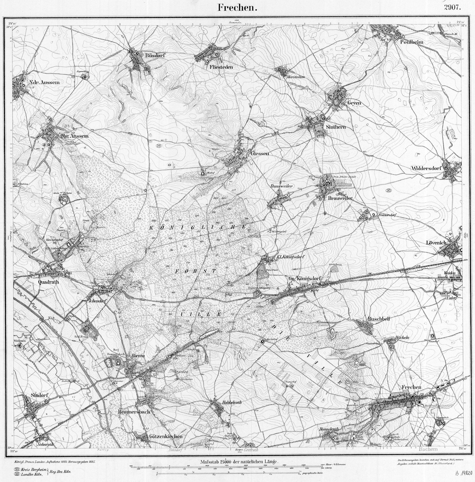
- ↑ Course and mill locations on the historical topographic map of Frechen from 1893. Retrieved on October 19, 2019 .
- ↑ Kölner Randkanal, progress plan 1:25 000. (PDF; 12.0 MB) Zweckverband Kölner Randkanal, accessed on September 4, 2010 .
- ↑ Maria Machnik: The mill is the heart , Kölner Stadt-Anzeiger, Rhein-Erft, from 23/24. January 2016, p. 36 about the Geyen Mill Park
- ↑ according to Horst Engel, Bachverband website
- ↑ List of monuments of the Pulheimer Geschichtsverein: Fronhof ( Memento of the original from March 18, 2005 in the Internet Archive ) Info: The archive link was inserted automatically and has not yet been checked. Please check the original and archive link according to the instructions and then remove this notice.
- ↑ Kölner Stadtanzeiger, Rhein-Erft, August 30, 2010
- ↑ Maria Machnik: On the way to the natural bed , Kölner Stadtanzeiger, Rhein-Erft, from February 2, 2010, p. 23, which quoted R. Zeese there. (online on February 4, 2010)
- ↑ Astacus astacus - release of the European crayfish in the renatured Pulheimer Bach, Pulheimer-Anzeiger.de ( page no longer available , search in web archives ) Info: The link was automatically marked as defective. Please check the link according to the instructions and then remove this notice.
- ^ Maria Machnik: The edible crabs are back , Kölner Stadt-Anzeiger, Rhein-Erft, September 17, 2013, p. 37
- ↑ Noble cancer project NRW. Retrieved October 19, 2019 .
- ↑ Horst Engel: Rescued Kingfisher was released. Pulheimer Bach entertainment association, accessed on October 19, 2019 .
- ↑ 100 stones become the "Blue Ribbon". Piped sections of the Pulheimer Bach are marked, Sunday Post Pulheim online Last change: Tuesday, Jan. 31, 2012 (accessed on Feb. 2)
- ↑ Kölner Stadt-Anzeiger, Rhein-Erft, from December 6, 2012, p. 36
- ↑ Kölner Stadtanzeiger, Rhein-Erft, January 13, 2011, p. 38
- ↑ KStA 4./5. Feb. 12, p. 46
- ↑ KStA of December 22, 2009 online ( page no longer available , search in web archives ) Info: The link was automatically marked as defective. Please check the link according to the instructions and then remove this notice. (Accessed Jan. 2011)
- ↑ Frechener weekend, Rhein-Erft-Kreis, from June 29, 2011
- ↑ The Pulheimer Bach Adventure Trail is inaugurated - The good work is valued - From cherishing to coming to protect (with picture gallery), Pulheimer-Anzeiger.de ( Memento of the original from December 13, 2013 in the Internet Archive ) Info: The archive link was inserted automatically and not yet checked. Please check the original and archive link according to the instructions and then remove this notice.
- ↑ Dennis Vlaminck: Return to the old bed, Kölner Stadtanzeiger, Rhein-Erft, from June 24, 2010, p. 34
- ^ Maria Machnik: Steles tell interesting facts KStA RE 23./24. April 2011, p. 45 Smart steles 22.4. online ( Memento of the original dated May 5, 2011 in the Internet Archive ) Info: The archive link was inserted automatically and has not yet been checked. Please check the original and archive link according to the instructions and then remove this notice.
- ↑ Britta Wonnemann: The water on the track in Cologne Stadt Anzeiger, Rhein-Erft, of 26-27. November 2011 and online with picture, November 27, 2011 (accessed December 12, 2017)
- ^ Maria Machnik in Kölner Stadtanzeiger, Rhein-Erft, from 27./28. June 2015, p. 36
- ↑ KStA RE of June 29, 2015, p. 31
Web links
- Website of the entertainment association Pulheimer Bach
- Adventure trail
- Classification of the Pulheimer Bach water axis at Regio Grün, details link below
- Rhenish Mill Documentation Center, Ralf Kreiner: Complete historical documentation of the mills on the Pulheimer Bach , Aachen, 2010 PDF
- Table sheet 5006 Frechen from 1893