Road of Energy
|
This article has been proposed for deletion.
If you are the author of the article, please read through what a request for deletion means and do not remove this notice. |
|
| Reason: The article has been around for a while now, but I don't understand why. So why? Pure advertising project by RWE without external reception (shown). There are only two links to RWE AG in the article. You drive from the power station to the lignite hole, but not to the Hambach Forest or to the resettlement projects. That can not be. What makes this road of energy worth visiting? Which sources deal with the project? (The first picture "Living Landscape" is also RWE Propaganda: What is "alive" about the hole shown?) 2A00: 6020: 1EEA: 8500: C024: 58EC: B8FD: 803A 18:50, Aug. 15, 2020 (CEST) |
The road of energy is a smaller adventure road on questions of energy generation, especially from lignite in the Rhein-Erft district and subsequent districts in the Rhenish lignite district of the Cologne Bay .
Emergence
In 1959, Paffendorf Park and Castle was taken over by the brown coal industry ( Rheinbraun ) in order to operate their Fortuna-Garsdorf opencast mine on its field . In 1976, a training, event and information center for the lignite industry was set up in the castle. Shortly after 2000, the successor company RWE Power cooperated with the Rhein-Erft district to provide this information service through a designated connection for bicycles and cars with the locations of lignite mining in underground opencast mines , recultivation of the charred areas and remaining open pit holes , and power generation of coal in Offering the public to power plants or processing as fuel in briquette factories . To this end, tourism students at the Cologne Business School developed a concept that was presented as a tourism promotion project by the municipalities of Bedburg , Bergheim and Elsdorf . Wind parks and photovoltaic systems complement the energy generation spectrum.
description

Two separate circuits ( often identical only between Frimmersdorf and Niederaussem ) for bicycle (37 km) and car (31 km) lead to 8 stations. The distance between the stations is indicated. A detour to the viewing platform at the Hambach opencast mine is 7 km from Paffendorf Castle (9 km by car) and can be planned separately. The route is marked by blue signs with a light bulb . The circuit is also suitable as a hiking trail . The traffic-free sections from Paffendorf to Lake Neurather are particularly recommended . A distance can also be covered optionally by train (Frimmersdorf). The detour to the Hambach opencast mine is also easy to hike. A free tour map (printout from the official topographic map 1: 50,000) is issued in the information center. The energy landscape accompanies the visitor incessantly with its steam from the cooling towers of the power plants and the necessary infrastructure through its own railway lines ( north-south railway from Garzweiler to Hürth-Knapsack and Hambachbahn ) and newly constructed or relocated roads and highways. The following stations are visited in detail:
Stations
- Paffendorf Castle (information center) with the lignite vegetation educational trail in the landscape park , which was included in the Route of Garden Art between the Rhine and Maas . (1.8 km)
- Wiedenfelder Höhe , high tip made from overburden , recultivated landscape after the opencast mine (Garsdorf). (6.3 km)
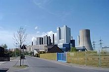
- Niederaußem power plant ( lignite power plant with optimized system technology (BoA) (0.9 km))
- Coal refining company Fortuna-Nord , coal refining and briquette production company from RWE Power, (11. km)
- Photovoltaic system Neurather See (to Grevenbroich ) (2.9 km)
- Wind test field Frimmersdorfer Höhe, electricity from wind (3.4 km)
- Recultivation in the area of the former Fortuna-Garsdorf opencast mine (as an example of necessary soil protection ) (7.3 km)
- Peringsmaar Tagebaurestlochsee (should, if left to its own devices, become a biotope ) (4.0 km to Paffendorf Castle)
- Hambach opencast mine , lookout point at the edge of the pit of the largest German opencast mine near Elsdorf-Angelsdorf (7 km)
continuation
The tour on the road can be continued in the north at Frimmersdorf / Neurath with the 38 km long cycle route Energiepfad Grevenbroich , whose southern loop goes to Gustorfer Mühle , the subsequent Nordschleife touches Grevenbroich station .
Directions
You can reach Paffendorf Castle with the Erft-Bahn from Cologne and Düsseldorf / Neuss as well as with the bus line 975, which goes to the stations Bedburg , Bergheim (Erft) , Horrem (Cologne-Aachen, RE 1 NRW-Express and RE 9 Rhein-Sieg-Express ) and Erftstadt- Liblar ( Eifelbahn ) connects ( Paffendorf stop ). By car, take the A-61 junction 18 Bergheim, then the B 477 to the L 361 towards Bedburg / Paffendorf.
literature
- Heidi Rüppel, Jürgen Apel: Germany EXCLUSIVELY EXCITING: To the locations of natural and cultural history, 25 suggested tours for a short trip . LSRB-Verlag, 2017 (Tour 10: Cologne Bay: Bergheim-Cologne. On the Energy Road through the earthquake area.)
Web links
- Street of Energy at rheinische-industriekultur.de
- Energy Road (PDF) on rwe.com
Individual evidence
- ↑ Hartmut John, Ira Diana Mazzoni: Industrial and technical museums in change. Location assessments and perspectives . Transcript , 2005 (p. 249)
- ↑ Tourism: "Straße der Energie" as a cycle path , Rheinische Advertisement Papers from July 4, 2018


