Fortuna-Garsdorf opencast mine
| Fortuna-Garsdorf opencast mine | |||
|---|---|---|---|
| General information about the mine | |||
| map | |||
| Mining technology | Open pit | ||
| Overburden | 2,090 million m³ t | ||
| Funding / year | Max. 48 million t / a coal (1979) t | ||
| Funding / total | 1,030 million t | ||
| Information about the mining company | |||
| Operating company | Rhine brown | ||
| Start of operation | 1953 decarburization from 1955 |
||
| End of operation | 1993 | ||
| Successor use | Backfilled, since then agriculture and local recreation area | ||
| Funded raw materials | |||
| Degradation of | Brown coal | ||
| Greatest depth | 360 m | ||
| Geographical location | |||
| Coordinates | 50 ° 59 '27.1 " N , 6 ° 37' 11.8" E | ||
|
|||
| Location | Glesch | ||
| local community | Bergheim | ||
| District ( NUTS3 ) | Rhein-Erft district | ||
| country | State of North Rhine-Westphalia | ||
| Country | Germany | ||
| District | Rhenish lignite district | ||
The open pit Fortuna Garsdorf is a former lignite -Groß surface mining in the Rhenish mining area .
location
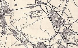
The opencast mine is located in the northern Ville in the Rhein-Erft district between the city of Bergheim with its districts of Auenheim , Niederaußem , Paffendorf and Glesch in the south and east and the city of Bedburg with its districts of Rath , Blerichen and Broich in the west and north.
Because of its proximity to Bergheim, the opencast mine was sometimes referred to as the Bergheim opencast mine . However, this designation is misleading because it is already established for the Bergheim open-cast mine , which is actually a little further south-east .
The open-cast mine is named after the Bergheim district of Kolonie Fortuna , a workers' settlement belonging to the Fortuna briquette factory , which was excavated in the mid-1980s due to the opening of the open-cast mine, and the Bedburg district of Garsdorf , which also had to give way to open-cast mining.
The Erft flows past to the west of the open-cast mine and had to be reburied especially for mining.
history
Development and operation
The opencast mine was opened up from 1955 to supply surrounding briquette factories (especially the Fortuna mentioned above ) and lignite power plants (especially the Fortuna power plant at the beginning , but also Niederaussem , Frimmersdorf and Neurath ) with fuel. The coal was transported to the nearby customers via conveyor belt systems , for others via the siding to the Hambach Railway, which passes in the south, and the North-South Railway .
During the mining phase, Fortuna-Garsdorf was the largest and deepest open-cast lignite mine in the world for a long time. The greatest depth was 360 m below ground, the total area about 2,200 ha (22 km²). The recoverable reserves of just over a billion tons of coal were almost completely mined in the 38-year operating period up to May 1993 . About twice the amount of overburden had to be removed (a very favorable ratio; open-cast mines currently in operation in Germany are much less favorable). For dewatering about 16 million m³ of groundwater had to be pumped out and the Erft had to be diverted.
At the end of the operating time, Fortuna-Garsdorf grew together with the Bergheim opencast mine further south , only separated by the overburden dump in between , which today forms the Wiedenfelder Höhe .
Dredged localities
In the course of the operating time, the below mentioned locations were partially or completely excavated. Around 2500 residents therefore had to be relocated.
| Locality | part of | Relocated | Dredged |
|---|---|---|---|
| Fortuna Colony | Bergheim | ||
| Garsdorf | Bedburg | 1963-1965 | 1965 |
| Frauweiler | Bedburg | 1963-1965 | from 1965 |
| Wiedenfeld with Monday end | Bergheim | 1963-1965 | from 1965 |
| Holtrop Castle | Niederaussem | 1958 | |
| Winkelheim | Bedburg | until 1977 | from 1977 |
| Buchholz | Bedburg | until 1977 | from 1977 |
| Giersberg | Glesch | 1968 | |
| Muchhaus , Oberschlag , Geddenberg , Bedburg-Ost | Bedburg |
Recultivation and subsequent use
After the carbonization was completed in 1993, the opencast mine was filled with overburden from other opencast mines in the region, in particular the Hambach opencast mine . Recultivation has been largely completed since 2004 .
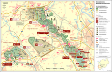
The areas in the south with the Wiedenfelder Höhe dump were restored for agricultural use. In the northwest, near Bedburg, an extensive, 120-hectare recreational area was created with the Peringssee .
The former route of the long-distance belt system between the Hambach opencast mine and the Bergheim opencast mine , which was used to transport overburden for backfilling the Fortuna-Garsdorf and Bergheim opencast mines for more than 30 years, was redesigned into a 5 m wide circular cycle path as part of the: terra nova project and paved. Contrary to the original plan of complete dismantling, the path can therefore be used by cyclists, skaters and pedestrians over a length of more than 10 km without crossing and leads from Elsdorf- Berrendorf-Wüllenrath via the Hambach opencast mine to Wiedenfelder Höhe near Niederaussem . Motor vehicles of any kind are not allowed to use the path. The route, also known as the speedway, is a project of the cities of Bedburg and Bergheim , the municipality of Elsdorf and the Rhein-Erft district .
The Erftverband uses a basin as a flood retention basin for the Erft with a storage volume of 1.6 million m³.
literature
- The Erdfresser - Opencast Mine - Fortuna Garsdorf. Geo 12/1976, Gruner + Jahr, Hamburg, pages 78–96.
Individual evidence
- ↑ a b c d e f Oberaußem - Fortuna and brown coal - 7. The Fortuna open-cast mine - Garsdorf at www.stadtteilforum-oberaussem.de ( Memento of the original from June 30, 2013 in the Internet Archive ) Info: The archive link was automatically inserted and not yet checked. Please check the original and archive link according to the instructions and then remove this notice.
- ↑ a b Lost places through the Fortuna-Garsdorf opencast mine on devastiert.de ( Memento of the original from July 18, 2011 in the Internet Archive ) Info: The archive link was inserted automatically and has not yet been checked. Please check the original and archive link according to the instructions and then remove this notice.
- ^ RegioGrün: Green Bridge Ville - Peringsee
- ↑ Project in the recultivated Fortuna opencast mine at www.forschungsstellerekultivierung.de ( Memento of the original from January 26, 2016 in the Internet Archive ) Info: The archive link has been inserted automatically and has not yet been checked. Please check the original and archive link according to the instructions and then remove this notice.
- ↑ Project: terra nova on bergheim.de
- ↑ Garsdorf flood retention basin on erftverband.de ( Memento from May 19, 2008 in the Internet Archive )


