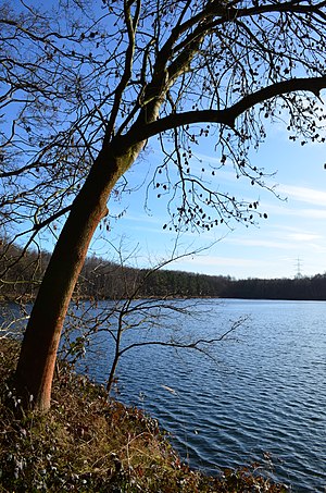
Concordia Lake (Erftstadt)
| Lake Concordia | ||
|---|---|---|

|
||
| View of the Concordia lake | ||
| Geographical location | Rhein-Erft-Kreis , North Rhine-Westphalia , Germany | |
| Tributaries | Groundwater and transfers | |
| Drain | Erft tunnel to the Erftmühlenbach (560 m) | |
| Places on the shore | Kierdorf | |
| Location close to the shore | Erftstadt | |
| Data | ||
| Coordinates | 50 ° 50 ′ 27 " N , 6 ° 48 ′ 9" E | |
|
|
||
| Altitude above sea level | 92.8 m | |
| surface | 11.9 ha | |
| volume | 590,000 m³ | |
| Maximum depth | 8.5 m | |
|
particularities |
Lowest lake level in the southern villa lakes |
|

|
||
| Map of the Villeseen | ||
The Concordia lake is a residual open pit lake north of Erftstadt in the Rhein-Erft district . The lake is located east of the Erftstadt district of Kierdorf , but is separated from it by the A1 .
Lake Concordia is part of the Rhineland Nature Park / Villeseen Nature Reserve . In the east the Köttinger See and the Roddersee adjoin ; in the north is the Zieselsmaar .
The lake itself is under nature protection. Protected spawning areas for amphibians as well as protection and resting areas for other animals are set up here all year round , which cannot be entered. Fishing, swimming, diving and other water sports are not permitted.
Emergence
The lake was created between 1955 and 1973 (approval) from a disused lignite mine in the "North" field of the 1958 disused briquette factory "Concordia" of the entrepreneur Carl Brendgen . Lignite was mined here from 1902.
After the dewatering in the remaining open pit hole was stopped, it was filled with groundwater .
See also
Individual evidence
- ↑ a b c d Rhineland Nature Park: Lake Concordia on naturpark-rheinland.de
- ↑ Redevelopment of the Erft tunnel KStA Rhein-Erft of March 11, 2014, p. 32
- ^ City of Erftstadt: Kierdorf on erftstadt.de (accessed on April 10, 2016)

