Grevenbroich energy path
| Grevenbroich energy path | |
|---|---|

|
|
| overall length | 38 km |
| Places along the way | Gustorf , Gindorf , Neuenhausen |
| Flooring | asphalted / farm roads |
| difficulty | familyfriendly |
| Connection to | Euroga between Rhine and Maas , Niederrheinroute , Kaiser-Route , Erft-Radweg , Straße der Energie |
| Website URL | Energy path |
The Grevenbroich energy path is a circular cycle path in the form of an 8 in Grevenbroich , which makes the connections between energy generation , lignite opencast mining and recultivation clear and also leads to plants that use renewable energies . Information about the flora and petrography there is on many notice boards .
The approximately 38 km long circular route was created in 2002 as part of Euroga . Among other things, it runs in the districts of Gustorf and Neuenhausen , on the Vollrather- and Gustorfer Höhe past wind turbines, lignite mines, Lake Neurath with one of the largest photovoltaic systems in Europe and the Elsbachtal , a recultivated brook valley with the Land Art project by Benoit Tremsal .
The northern circular route and the southern district cross and touch at the Gustorfer Mühle with its water turbine from the 1930s, which is used again today to generate electricity. You can only use one of the circular routes and cut the tour in half.
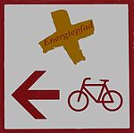
The signet shows an inclined yellow cross with the word Energiepfad . There is a risk of confusion with the sign of the Euroga cycle path between the Rhine and Maas , which was also created as part of Euroga 2002, because these two cycle paths often cross.
The tours on the Energiepfad can be continued south from Frimmersdorf / Neurath with the Straße der Energie to the information center in Paffendorf Castle .
Coordinates: 51 ° 5 ' N , 6 ° 34' E
swell
Web links
- Detailed guide to the Grevenbroich energy path ( memento from June 22, 2015 in the Internet Archive )
