
Alt-Huerth
Alt-Hürth is a district of the city of Hürth in the Rhein-Erft district . Alt-Hürth has about 7,000 inhabitants (as of mid-2011).
Even before industrialization, the place was an important church place, even with a vicarie , and with (1880) 1166 inhabitants about the same size as the residential city of Brühl (without assigned places). The mayor's office (1800/1815) and the large community formed in 1930 therefore rightly received the name Hürth, even though the administrative center was relocated to Hermülheim and 1985 to Hürth-Mitte between Hürth and Hermülheim. In the rest of the text, the old name Hürth is mostly used for historical and geographical statements for the district . Even today Alt-Hürth has a distinctive shopping, gastronomy and service center, albeit for rather simple needs.

location
Alt-Hürth is located in the Hürth valley of the Duffesbach on the slope of the foothills west of the Luxemburger Straße , the B 265 , about ten kilometers southwest of Cologne .
history

Romans, early times, first mentioned
Hürth, the original name of the current district of Alt-Hürth, which gives the city its name, is first mentioned together with the ruezinhof , the Rüscherhof, in 1185 in a deed of donation from Philipp von Heinsberg to the St. Mechtern monastery in Cologne . It appears as a church location for the first time around 1300 in the liber valoris . The patronage of the church, St. Katharina , and the substructure of the tower suggest an older own church of the respective castle lord from the middle of the 13th century at the latest. Since the Romans took the water from Hürth jumps and led to Cologne in an aqueduct , the Hürth line and its branches, along the snake path and the Kreuzstrasse, the settlement of the Hürth valley can be assumed to be quite old. On the Kummet, at the end of the Hürther valley, about 100 m below Kreuzstrasse, a larger villa rustica of 80 × 30 meters has been excavated in places. Early graves have been found in the area.

Feudal times
In the late Middle Ages and in the early modern period the area around Hürth was divided between the Archdiocese of Cologne and the Duchy of Jülich . The district of Hürth (Alt-Hürth) was in between and belonged (without Knapsack, Alstätten and Villenhöhe) to the rule of Valkenburg in the Duchy of Brabant and thus to the Spanish , later Austrian Netherlands . Nevertheless, the Jülich and Cologne always interfered in Hürth affairs. Street names in the new building area around the newly laid out Valkenburger Platz are reminiscent of the former lords of the castle, who usually changed through marriage: Von Holtrop (1416), von der Horst (1439), von Harff (1552), von Tzerklaes (1675), von Reuschenberg (1749) ) and finally by Wolffen (1760). As a result, the lands were parceled out and sold, and castle farming was abandoned. The buildings, which were probably last extensively renovated in 1691 by the lord of the castle Tzerklaes, fell into disrepair. The castle was next to the old church. A castle hill supported by a wall on the east side is clearly noticeable here. As you can see on the Tranchot map from 1807/08, the utility buildings were located on three sides to the west, parallel to today's Lindenstrasse, from where the access road was also. A larger building can be seen at the southwest corner of this block, to which a rectangular inner courtyard was attached. The situation on the southeast side is unclear. The small church there next to a castle house (without the later extensions) with the churchyard surrounded by a wall formed the northeast corner of the area. With the exception of the church side, the complex was surrounded by a moat. Possibly there was a narrow connection of the moat between the church and the castle house with the part of the moat that was enlarged to the east to form a narrow castle pond. The Weierstrasse (sic) that leads past reminds us of the castle pond. When the municipality bought the castle complex (1865), no ditches can be seen on the map drawn for it. In addition, the buildings in the outer bailey have disappeared except for a narrow servants' house and barn. The stable marked to the left of the driveway has been crossed, so it is probably already in serious disrepair. A year later the parish took over the site, tore down the dilapidated castle house and built its new rectory on the foundation walls. The Lords of Hürth also had blood jurisdiction until the French era . The Hürther Galgen stood at the intersection of today's Bergstrasse with today's Luxemburger Strasse and thus at the highest point in the rulership. A small hill can still be seen on the tranchot map. In the Napoleonic period, after the abolition of the manors, (old) Hürth was assigned to the mayor's office (later office, French: Mairie ) Hürth with its seat in Hermülheim . The mayor was a wealthy person who lived in the village. When Franz Rosell, who came from outside (Longerich) in 1851, became mayor (→ his son Heinrich Rosell inherited him as mayor), he could not find a suitable apartment in the village and was therefore given permission to build a new house in Hermülheim.

Farmers and mills
In addition to the castle courtyard, there were only a few medium-sized courtyards in and around the village. There were also a number of tiny farmhouses for the dependent courtiers, which can still be seen changed in many ways in the cityscape. Around 1880 Hürth had a total of 242 houses.

For a long time, the Hürther valley was characterized by four mills , with the manor mill at the end of the valley at Hermülheim even by five mills. There was even a Hürth war with Cologne and negotiations before the Reich Chamber of Commerce in Nuremberg over water rights . Only one building remains from the Metternichsmühle. The other mills are still remembered with old Hürth street names. The Hürther Talmühle restaurant even attracted Cologne day trippers. Today there is a somewhat more modest restaurant with a small hall on Talmühlenstraße. At the end of 2010 this restaurant was converted into a pizzeria with a typical name. With the loss of the old name, a piece of Hürth tradition disappeared.
First lignite mining
(→ Lignite in Hürth )
Lignite was found early on in the area around the district and mined in a rural manner for personal consumption, for example in the Duffesbach valley , which had cut these coal seams . On a plain from the archive of Kendenich Castle from 1769, the Kentenischer and Hürther Dorffkaulen can be seen in the basin of the Duffesbach (on the grounds of the Knapsack tennis club, the former Firmenich brewery). When the peat was dug up on the slopes, holes were dug and the coal from these holes was partly mined underground and brought up with reels . In loose rock this was not without risk. The charcoal was pressed into shapes like flower pots, turned inside out and dried in the air as lumps . Mine lords were the castle lords and landowners, mine workers the day laborers from the rural population. The first larger mine since 1800 was the Scholls mine operated by the Hürth mayor family Scholl , later named after the wife Theresia , on the border to Hermülheim (today Theresienhöhe). The Alt-Hürth allotment garden association near the cemetery in recultivated area is also named after Theresia .
industrialization

The upswing of the place Hürth began with the rapid development of the Rhenish lignite mining area and the industrial settlement in Knapsack after 1900. As a result, and especially through the purchase of the lignite mines, agriculture in Alt-Hürth declined considerably. Today there is still one farm, the Bolderhof on Mühlenstrasse , which operates on a sideline basis with mainly leased land. The district itself was largely spared from industrial settlements. Even the mining company and briquette factory that Hürth had in its name, the Hürtherberg trade union , had its headquarters north of Hürth on the boundary between Hürth and Hermülheim and Kendenich. Lignite mines existed around Hürth until 1988. They were connected to the works by an extensive 900 mm narrow-gauge railway network that migrated with the mining. A locomotive and several wagons are an industrial monument on the Frechener Strasse / Alstädter Strasse roundabout opposite the mosque. Since 1918 the Black Railway ran from the Vorgebirgsbahn in Hermülheim through the Hürth Valley to Knapsack and to the pits and briquette factories in Berrenrath. Until the abandonment of passenger traffic (today still factory traffic of the ports and goods traffic from Cologne to Knapsack), there was a train station with loading platform on Trierer Straße and a stop at the Hürtherberg factory and the Talmühle. In the area of this stop, but not only there, many company apartments of the Knapsack industry were built especially for the workers of the companies RWE and Rheinbraun . The Villebahn , which connected the Ribbert (Kendenich), Hürtherberg (on Luxemburger Straße), Theresia (Hermülheim) and United Ville (Knapsack) mines with the state railway, ran above the town around the town (dismantled). The Engelbert mine (Berrenrath) was connected to the Ribbert factory via Hürth with a cable car to Hermülheim. With the upswing after the First World War , noteworthy buildings such as the first swimming pool in the Cologne area, a stadium and a cycling track as well as modern school buildings could be built in Hürth . These buildings on Brabanter Platz are now a listed building. After 1930, the then established large community of Hürth also benefited from this . In this merger, the wealthy Hürth did not necessarily welcome the poorer, incorporated towns. After the city charter was granted in 1978, the district of Hürth was renamed Alt-Hürth by a council resolution of April 22, 1979 with a narrow majority in order to avoid confusion. However, the name Alt-Hürth already appears in the home register of the municipality of Hürth from 1934 for the district.
Change in economic structure
(See main articles Hürth , Hürth-Knapsack , Goldenberg power plant , Knapsack chemical park and the Rheinisches Braunkohlerevier )
With the end of lignite mining, the disappearance of the briquette factories around Hürth (there is still a factory today: Ville / Berrenrath ), the use of dust filter and desulfurization systems at the power stations on Knapsacker Hügel and the structural change in the chemical industry, the air and Quality of life in Alt-Hürth has increased significantly.
Alt-Hürth today


Due to its location in the Hürther Valley, the place has developed a center that is formed from the rectangle with the long sides of Weierstraße and Lindenstraße and the narrow sides of Pastoratstraße / Mittelstraße and Brabanter Platz in the north. A number of shops for daily needs have settled here and have been maintained to this day, which are supplemented by some shops for medium and high-end needs (shoes, furniture, optics and radio). Since the business premises are small, old (written off) and cheap or belong to the business owners themselves, even small specialist providers such as wine and spirits specialties can even hold small boutiques. Largest retail business is a REWE - supermarket . In addition, there is plenty of parking space and free. Nevertheless, the competition with the Hürth Park shopping center (Hürth-Mitte) and Cologne is considerable and occasionally results in vacancies. Noteworthy in Alt-Hürth is the range of upscale restaurants and cafes to the plentiful supply of traditional and foreign / exotic fast food. The city supports this center through the establishment of traffic-calmed zones and city marketing measures . An advertising and support association tries to keep the offer of the location attractive through events and advertising measures. The number of private art schools in the district is remarkable, offering courses for children and adults and enriching the cultural offerings with events. They use spaces that were previously used by retail stores.
Since the supra-local traffic is routed around the edge of the town, Luxemburger Straße to the east, Industriestraße, which connects the plants to the Luxemburger, to the south, Frechener Straße to the west and Theresienhöhe to the north, the inner-town streets can all be kept traffic-calmed, the inner square even at a speed of 20 km / h. The city bus connects the district on weekdays to the Hürth Park shopping center , the light rail and other regional traffic. The collective call taxi operates at times when there is less traffic and on Sundays .
Structural change in the place of residence
The living environment itself has changed from an industrial worker location to a medium-sized location for the service society . This also leads to the fact that the many workers' settlements are being privatized by the factories and, after thorough renovation, are being sold as homes or condominiums. Former industrial areas such as the Valkenburger place on the Ohremgelände or the former nursery of RWE , still recalls the the Grade II listed timber-gardening buildings by modern residential buildings with district heating (coupled with the gold mine ) or geothermal heating compressed.
Church, culture and carnival

Catholic Church
In the center of Alt-Hürth you can see two church towers. The onion dome belongs to the former church of St. Katharina , probably the youngest church to be founded in the old communities, but still the oldest church building in the city of Hürth, the tower base of which dates back to the Gothic period (arched windows). The choir dates from 1696, extensions and alterations took place in 1780 and 1919. After its profanation, the church was used as a monastery and kindergarten as well as a sewing school etc. from 1914 to 1984 and then rented as a medical center and dialysis center until 2005. Since 2007 it has housed a private music school, which enriches Hürth's cultural life with concerts in its rooms. It is a listed building. The "new" Church of St. Catherine from 1894/1895, built in a neo-Romanesque style by the Cologne architect Theodor Roß , is also a listed building. The interior was partly taken over from the previous church, which in turn inherited the disbanded Marienborn Hürth-Burbach monastery and Cologne monasteries. The baroque high altar with its crucifixion group is remarkable . The organ from 1903 with its traditional prospect comes from the workshop of Ernst Seifert in Cologne-Manstetten. It was restored by his son in the early 1960s. Today it is overhauled and serviced by the company Josef Weimbs . The second saint venerated in Alt-Hürth is the Apostle Matthias , in whose honor there is a pilgrimage on foot to St. Matthias in Trier every Saturday after Ascension Day . A memorial cross for the pilgrimage is on Trierer Strasse. The Catholic congregation has formed a parish association with Berrenrath , Fischenich and, since 2006, also with Kendenich . The ensemble of the two churches harmonises with the equally listed buildings of the swimming pool and vocational school as well as the not far away Löhrerhof as the cultural and historical center of Alt-Hürth.
Evangelical believers
Believers of the Protestant denomination only came to the place with industrialization. In 1933 (Alt-) Hürth with Alstädten had the second highest share in the large community of Hürth after Knapsack (745) with 551 Evangelicals. The believers went to Knapsack since 1921 to a simple wooden church, from 1951 to the Dankeskirche , which was demolished with the resettlement of Knapsack in 1976. The Evangelical Church Community Hürth also maintained a parish room in Alt-Hürth at times. Today the believers have to go to the Martin Luther King Church in Hürth Mitte, the Nathan Söderblom Church in Kendenich , to which Alt-Hürth belonged in the meantime, was given up in June 2008 for cost reasons.
Muslims
On the outskirts, near the cemetery on Frechener Strasse, the Muslim community built a mosque out of 240 enrolled believers , which was inaugurated in May 2004. It is also visited by foreign Muslims.
Former Jewish community
In the French era , the Jewish believers received (almost) equal civil rights. According to a decree by Napoleon of July 28, 1808, they had to decide on a family name and declare it on record in front of the mayor. Mayor Scholl recorded 41 people for Mairie Hürth on October 27, 1808, including 22 Levi , 15 of whom kept their respected names and 7 from a Levi family took the name Heyd. One family, Heumann (Ben) Seligmann and his son Seligmann (Ben) Heumann, chose the surname Brunel, which was adapted to the time. In 1847, Hürth comprised 92 people, the third largest Jewish community in the Cologne district , after Deutz and Frechen. An official synagogue community was formed together with Brühl in 1875 , since 1926 as an independent community. A prayer room ( Beth Midrash ) was used since 1856 in the house of a merchant Cosmann Brunel in today's Weierstrasse / corner of Kendenicher Strasse. After the merchant moved to Cologne and sold the house, a small synagogue was built in 1882 on a remaining plot of 62.2 m² with a narrow entrance to the street . In 1888 the synagogue community acquired ownership of the property. Before the persecution, 46 people lived in Hürth in 1932. In 1937 the community had to be dissolved at the instigation of the district president due to the reduced number of members and added to the Cologne community, which in turn had to sell the synagogue to a neighboring carpenter in 1939. On October 10, 1944, the former synagogue and the surrounding buildings were destroyed by a bomb attack.
The (old) Hürth Jews (around 50 in 1933, 11 in 1939) were, insofar as they were unable to emigrate, forced into a Jewish house in Grosse Ölbruchstrasse by the Nazi politicians in Hürth during the Nazi era and later deported and killed. A plaque at the Weierstrasse building and the central square at the old synagogue reminds of the synagogue . The fate of the persecuted is remembered in several places in the Alt-Hürth district, where Jews and Communists preferred to live, but also in the other parts of the city with stumbling blocks . The city named six streets after former Jewish residents.
There is evidence of a small Jewish cemetery for the exit towards Marienborn Abbey (Hürth-Burbach) on the right-hand side, today Marienbornweg, Old Cemetery . It was occupied until around 1880 and then replaced by a larger cemetery a little further out , a district on the Streufenberg , which the merchant Brunel also made available on a property that he had previously bought in 1874. The old cemetery was sold to RWE in 1922 , which, as in many other places in Hürth, built company apartments there. The new cemetery had to be sold to the Roddergrube and later fell victim to lignite mining.
Culture

In 1988 the Löhrerhof on Lindenstrasse in the center of Alt-Hürth was extensively restored and set up as a Hürth cultural center. The events of the Hürthers and the Alt-Hürthers take place there and in a hall of the restaurant at Bei Paula in Lindenstrasse. There are a number of choirs in the city of Hürth, in which the old Hürth people also like to sing. However, there are no special Alt-Hürth choirs. Another place of cultural life in the Alt-Hürth district with events and concerts has been the concert hall of the private music school "Auftakt" since May 2007 (for other private schools / course organizers, see schools). After the closure of the Catholic public library, there are now no books or bookshops in town. For official libraries, see Hürth.
carnival
Carnival is very important in Alt-Hürth. The Hürth Funken Blau-Weiß from 1938, the Prinzengarde Rot-Weiss from 1947 and the Große Knapsacker Carnival Society from 1935 are particularly active and large. The activities of all Alt-Hürthers and the Knapsack Carnival Society are coordinated by the Alt-Hürth Carnival Festival Committee. The train leaves on Carnival Saturday.
Sports
Sports clubs in Hürth are usually not restricted to one district, but open to everyone. The DJK TuS Hürth from 1964 may stand for Alt-Hürth, as well as the journeymen Alt-Hürth, who have signposted a permanent circular hiking trail around the Otto-Maigler-See starting from Alt-Hürth. In addition, the Hürth ski and hiking enthusiasts can be mentioned. All sports in the city can be found on the city's official website.
All activities of the old Hürth associations are coordinated by the local community, in which all associations in the district are represented.
Attractions
(→ List of architectural monuments in Alt-Hürth )

- Church building Old and New Katharina with parish hall from the 1930s with a memorial to Dr. Arnold Kürten and war memorial for the participants (not the fallen) of the glorious campaigns of 1848/49 ( Schleswig-Holstein War (1848–1851) ), 1864 ( German-Danish War ), 1866 ( German War ) and 1870/71 ( Franco-German War ), one of the oldest war memorials .
- Today's listed rectory was built in 1866 in half-timbering on the foundation walls of Hürth Castle. The civil parish had last acquired the ruined castle complex, from which the parish bought it. The former rectory was in Pastoratstrasse. It was already described by the pastor in 1817 as looking more like a stable. The lands belonging to the castle had also been sold in plots. A coat of arms on the rectory wall, which was found in the rubble on the former cemetery wall (replica, original in the parish hall building), reminds of the former Lords of Glory Hürth . It bears the inscription JOAN ERNS FL TSERCLAS. HEIR AND LANDLORD OF HURT, TOP OF ROSS EXTRUIT (expansion) 1691 . In addition, his wife's coat of arms lion (Tzerklaes) and tournament collar (Harff).

Löhrerhof in Lindenstrasse

Pastoratstraße, background with Paula

Erbenhof, Breite Strasse

Erbenhof, gable


- Half-timbered houses:
- The Löhrerhof is a three-sided former smaller courtyard with a two-story residential building on the left, gable -end, transverse barn and stables / shed and feed kitchen on the right. There used to be a bakery to the right of Lindenstrasse, which fell victim to the road widening in 1954. The courtyard is closed off from the street with a wooden gate. Originally, the pastor Peter Klinkhammer, who was in office in Hürth from 1830 until his death in 1878, built the house for himself and his brother-in-law, Böttcher Reiner Löhrer, with his family of six in 1839/40 . The economic complexes seem to have been built after 1870, when his son Michael Eva Kohlhaas, the daughter of the miller from Kohlhaasmühle, who brought a lot of land into the marriage, married. The half-timbered buildings seem to be the last of their kind in the district, only the plastered rectory is a few years younger. In 1915, after an initial sale of 131 ares to Gruben and the city, the farm still had seven acres, eight cattle, three pigs and twenty chickens. After the farm had to sell most of its land to lignite mines and the community (1888-1910 and 1970), agriculture was severely restricted and then abandoned in the 1980s. In 1986 the courtyard was bought by the city of Hürth, extensively restored according to plans by the Hürth architect Henning Bertermann and converted into a cultural center. The ensemble of the small courtyard is a listed building.
- What is now known as the Erbenhof at the lower end of Breite Straße, also a three-sided courtyard , was built around 1790. It was placed under monument protection in 1992 and acquired by a property developer from a community of heirs in 1995/98. After the dilapidated commercial section was torn down, the one-storey 114 m² house was extensively restored under the architect Bertermann and a three-storey house with six rental apartments was built in place of the old parts of the building. The yard of the complex is open to the street and has a show fountain. The one-story five- stand house is typical of the smaller farms in the region: the houses all face the street with one side facing the property line, the entrance is from the side. From there, the middle of three rooms, the kitchen, living room, study and hallway with stairs lead to the storage room, in which there was often a small attic room facing the street. The kitchen stove, standing on the side of the street, also heated the living room through a cast-iron plate . Only this room had windows facing the street and the courtyard.
- Two small, unrestored cottages in Pastoratsstrasse are under monument protection (picture).
- A Kotten at the upper end of the Breite Straße with a much smaller area of around 4 × 8 m, arguably the smallest house in town, is a typical example of the frequent househouses of part-time farmers. The outbuildings standing in a row have been converted into residential buildings and are not worth seeing. The house itself has not been restored, but has been painted and is in relatively good condition (uninhabited and not yet protected). The house seems to have been built after 1810, as it cannot be made out on the tranchot map.
- The Kotten on the square of the synagogue (18th century) is in good condition and worth seeing, but not a listed building. The house of the small U-shaped courtyard stands on the eaves of the square, but its actual front faces the side street and is closed off with a gate.
- A half-timbered house on Lindenstrasse with a restaurant.
There are other Kotten in the village, but these are mostly not recognizable as half-timbered houses because they are plastered or walled.

Smallest househusband
Art Nouveau house 1904
Breite Strasse
New as old, Breite Strasse

Half-timbered restaurant Lindenstrasse


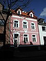
- A new house built on the old floor plan and based on Art Nouveau style from 2002 and a house from 1904, i.e. before industrialization, with a stylishly renovated Art Nouveau facade, both in the Breite Straße, are not protected but are examples of successful urban renewal.
- School and former indoor swimming pool from 1930 on Brabanter Platz (listed building)

- The RWE factory housing estate at Am Clementinenhof and the housing estates on the Villenbahn and Tilsitstrasse are listed buildings. Simpler, partially refurbished single-family and multi-family houses that look the same are typical for an industrial location, but are not listed. You are in the area Thalmühlen- / Mühlen- / Firmenich- / Breite-Straße, as well as on both sides of the Kreuzstraße.
- Crossroads made of power plant pipes, designed by trainees at the Goldenbergwerk, at the corner of Mühlenstrasse and Firmenichstrasse (replacement for a former wooden cross).
schools
- The community elementary school "Am Clementinenhof" from 1954 has Alt-Hürth as the sole school district.
- The Bodelschwingh School from 1964 is a Protestant elementary school and has the whole city as its school district. It was the first open all-day school in Hürth. It replaced the ev. School in Knapsack.
- The Goldenberg Vocational College of the Rhein-Erft district with a high school diploma is a European school and regionally relevant.
- The Rhein-Erft Academy in the Hürth section of the Knapsack Chemical Park . It offers training and further education for industry under private sponsorship, and since 2007 also a BA course .
- The private music school kick-off in the "Old Monastery of St. Katharina".
- The private dance, ballet, drama and kutaekado school is dancing! Artcenter diagonally opposite the Löhrerhof
- Carnival dance training for children and young people from the carnival clubs

Sports facilities
The formerly central sports facilities from 1930 have fallen back in importance or even given up:
- Stadium ( FC Hürth plays here ) with a cycling track (out of order, used as a sports practice area) and tennis courts (on the former Theresia mine site ) opposite Hürth Park
- Swimming pool as indoor pool (until 2007)
Green areas / recreation


- At Brabanter Platz between the two churches, the former churchyard has been converted into a green area equipped with a privately donated fountain.
- Next to the Kreuzstraße on the route of the dismantled Villebahn and the route of the old Roman foothills water pipeline , one of the few green spaces accompanying the road is laid out. The Roman Canal hiking trail that runs by here is also pointed out here. From 1986 a decommissioned steam locomotive from the DEGUSSA plant in Hürth stood here as a technical monument. In 1991, this in collaboration with the Rhineland Industrial Railway Museum in Cologne by a narrow gauge - Feldbahn the manufacturer Gmeinder replaced. Although this locomotive was never used in Hürth itself, it is typical for numerous works and mine railways, as they were used in a similar form in Hürth in industry and in lignite mining. In 2012 the train was renovated at the instigation of the SPD district Alt-Hürth-Knapsack, trainees of the CJD in Frechen, as well as trainees of the RWE in Knapsack and with the help of sponsors.
- The former Hürtherberg mine with the Adolf-Dasbach -Weiher and the spoil dump above Alt-Hürth next to Luxemburger Straße ( Hürther Kipp ) is designated as a local recreation area and is under landscape protection . The Naturfreunde youth hostel is also located there .
- To the north-west of Alt-Hürth, on the other side of Frechener Strasse, a forest-recultivated area joins the Hürther Waldsee nature reserve as far as the Otto-Maigler-See . The area is made accessible by a circular hiking trail. Behind the mosque is the Theresia allotment garden .
- The Alt-Hürther Friedhof is on both sides of Frechener Straße.
politics
Alt-Hürth is connected to Knapsack as a district. The mayor is Thomas Fund (CDU, from Alt-Hürth). The district is represented on the city council by Gudrun Baer, Björn Burzinski and Frank Rock (CDU all directly elected) and Katja Niewiesch (SPD), all from Alt-Hürth. Alt-Hürth is part of the Alt-Hürth / Knapsack / Kendenich / Fischenich district electoral district, which is represented by Willi Zylajew (CDU, directly elected) and Friederike Seydel (Greens) and Martina Thomas (Die Linke) (via the reserve list).
Personalities associated with Alt-Hürth
- Adolf Dasbach (1887–1961), mine director Grube Hürtherberg , who carried out the first recultivation of lignite mines and was co-founder and first chairman of the Heimat- und Kulturverein
- Wilhelm Disselbeck (1914–2001), doctor in the Breite Strasse (today Dr. Raked's practice) and medical officer, Federal Cross of Merit, 1st class
- Karl Ingenerf (1923–2005), primary school rector , honorary mayor (CDU), honorary citizen, co-founder of numerous Hürth initiatives (e.g. hospice, senior citizens' union, home and cultural association)
Literature / Sources / Notes
- Robert Wilhelm Rosellen: History of the parishes of the deanery Brühl , JP Bachem Verlag Cologne 1887
- NS-Lehrerbund Hürth-Efferen (ed.): Heimatbuch der Gemeinde Hürth , Cologne 1934
- Clemens Klug: Hürth - how it was, how it was , Steimel Verlag, Cologne undated (1962)
- Walter Buschmann , Norbert Gilson, Barbara Rinn: Brown coal mining in the Rhineland , ed. by the Landschaftsverband Rheinland and MBV-NRW , 2008, ISBN 978-3-88462-269-8
- Other literature see article Hürth
- ↑ Rosellen, p. 101 and 338 f.
- ^ Leonard Ennen , Gottfried Eckertz: Sources for the history of the city of Cologne 6 volumes, Cologne 1863/79, vol. I, p. 99
- ↑ Jakob Baumann: Rural settlements in the area around Roman Cologne , Hürther Heimat 75, 1996, p. 80 f. and Günther Frenzel: The Römerhof in Hürth , in Hürther Heimat, 39, 1977
- ↑ Clemens Klug: Hürth - how it was, how it became , Cologne o. J. (1962), p. 67
- ↑ Hürth City Archives, inventory 1.10, No. 18 V.
- ↑ Rosellen, p. 342
- ↑ Manfred Faust: History of the City of Hürth , ed. from Heimat und Kulturverein Hürth, Cologne, JP Bachem Verlag, 2009 p. 63 ff
- ↑ Rosellen, p. 338
- ↑ Illustration in Klug: Hürth after p. 64, the colored original is in the historical archive of the city of Cologne , last and reduced in color in Buschmann et alii, p. 37 and 268 with the already abandoned Förster's pit in the coming forest of the Hermülheim German rulers at Knapsack.
- ↑ Klug, Hürth, pp. 112, 195 and Plate XIII
- ^ Hürth coal railway . Support group of the Schmalspurkohlebahn Alt-Hürth eV Accessed on June 30, 2019.
- ↑ For the history of the pits and railways with old maps see Buschmann et alii: Brown coal mining in several places
- ↑ Hans Duell: The chronicler remembers , in Hürther Heimat, Heft 61/62, p. 138
- ↑ NS-Lehrerbund Hürth-Efferen (ed.): Heimatbuch der Gemeinde Hürth , Cologne 1934, p. 129
- ↑ Heimatbuch p. 133 f
- ↑ Section: The Protestant Church Community in Knapsack , Heimatbuch der Gemeinde Hürth, 1934, p. 161
- ↑ Napoléon and the Jews (French)
- ↑ Eric Barthelemy: The choice of names of the Jews from Hürth from 1808 in Hürther Contributions Vol. 90 (2011), pp. 61 to 66
- ↑ Street directory with explanations ( Memento from March 5, 2012 in the Internet Archive )
- ↑ Manfred Faust: On the history of the Hürther Jews , in: Hürther Heimat , No. 69/70 (1992), p. 36 ff and Lothar and Maria Sterck: On the history of a half-timbered house in Alt-Hürth , in Hürther Heimat , 63/64 (1989), p. 57 ff (with documents), Manfred Faust: History of the City of Hürth , Bachem-Verlag, Cologne, p. 96 ff and 147 ff
- ↑ Rosellen, p. 350
- ^ Heinz Firmenich: City of Hürth , Rheinische Kunststätten, issue 36, 2/1989, p. 7
- ↑ Clemens Klug: Documentation on the history of the Löhrerhof in Alt-Hürth , in Hürther Heimat , no .: 58, p. 22 ff
- ↑ Elmar Brohl : Hermülheim and the German Order , Hürth 1975, p. 110; after Hans Vogts : The Rhenish Farmhouse in its house types Cologne 1932
- ↑ a b Peter Ziegenfuß: Monument, Kreuzstraße 86, 50354 Hürth-Alt-Hürth. Bahn-Express, 2006, accessed December 3, 2012 .
Web links
Coordinates: 50 ° 52 ' N , 6 ° 52' E

Alstädten-Burbach | Alt-Huerth | Berrenrath | Efferen | Fischenich | Gleuel | Hermülheim | Kalscheuren | Kendenich | Knapsack | Sielsdorf | Stotzheim