
Duffesbach
|
Duffesbach Huerther Bach |
||
 Below Efferen |
||
| Data | ||
| Water code | DE : 27354 | |
| location | North Rhine-Westphalia , Germany | |
| River system | Rhine | |
| Drain over | Rhine → North Sea | |
| source | At Hürth 50 ° 51 ′ 41 ″ N , 6 ° 51 ′ 7 ″ E |
|
| Source height | approx. 120 m above sea level NHN | |
| muzzle | In Cologne in the Rhine coordinates: 50 ° 56 ′ 3 ″ N , 6 ° 57 ′ 49 ″ E 50 ° 56 ′ 3 ″ N , 6 ° 57 ′ 49 ″ E |
|
| Mouth height | 44 m above sea level NHN | |
| Height difference | approx. 76 m | |
| Bottom slope | approx. 5.9 ‰ | |
| length | 12.9 km | |
| Catchment area | 10.093 km² | |
 The Duffesbach flows into the Rhine in Cologne, near the Rheingasse. Only visible when the Rhine is extremely low. Here Rhine level Cologne 72 cm on October 21, 2018. |
||
 Cologne and the Bach approx. 16th century |
||
The Duffesbach achieved the only creek in the Cologne bay in Cologne the Rhine . This is because that as a follow- flowing waters in Roman times by water engineering measures designed Hürther line from the Hürther valley in an artificial river bed the medieval Cologne guilds had to serve and commercial operations. This is also unique. Before this time it seeped into the gravel near the step of the Lower Rhine central terrace between Kalscheuren and the military ring , as evidenced by deposits ( colluvia ) there and missing colluvia on the recent stream route.
Name of the stream
In earlier times the brook had different names. In Cologne it was called like the Gleueler Bach, only the Bach . The street that accompanied the brook in Cologne is called the Cologne brooks as a whole . Before Cologne his name was mostly Hürther Bach . The meaning of the name Duffesbach is unclear. The attempts at interpretation according to Tuff-Mühle or Duffes / Taubenhaus do not make any real sense, but cannot be ruled out either.
swell

The sources of the brook are in the Ville near Knapsack . Three source streams, coming from the Kranzmaar as well as northwest (Hürther Bach) and southeast of Knapsack (Knapsacker Bach), united above the Hürther Talmühle . This source horizon has largely changed and dried up due to the lignite mining in the Ville and has also largely been shaped by the Knapsack industry . The stream begins today below the sewage treatment plant of the chemical park near the former stop of the former route of the Black Railway . Most of the stream water now flows from pipes that drain the chemical park's grounds. Further sources ( cracks ) and smaller channels (22) from the many broichs in the Hürther Valley are listed in a document from 1773. In the past, they were taken to improve the water flow and fed into the stream. Despite the short run, the Ville streams were relatively productive, because the ground water above the underlying tone jammed that it supported lignite stored water and the Cologne and the Ville-Scholle are tilted to the northeast.
Stream
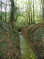
Leaving the Hürther Tal, the stream is swiveled at right angles to the west in the direction of the old Hermülheim Castle and led across the flat ridge of the Theresienhöhe, formerly in a brick open bed through Kirchstrasse / Severinusstrasse, today piped. In storms it often spilled over the Luxemburger Strasse again. The bed there had to be repaired again and again. From the castle it flows straight and open parallel to the former aqueduct through Efferen ( piped in Bachstrasse ) towards Cologne. Below Efferen, it used to take up the Stotzheimer Bach (upper course: Bornbach also Burbacher Bach ) as the only tributary that is now routed into the Cologne Rand Canal . Water is also diverted from the Duffesbach into the edge canal during heavy rain or when there is a large amount of water. He reaches Cologne on the autobahn. In the city district of Lindenthal, it flows canalised under Luxemburger Straße . At the Weißhaus it used to fill the manor's pond. The entry into the medieval city area was at the Bachtor . From there it flows, open in the Middle Ages, now channeled, past the old Roman wall with the Roman south gate Hohe Pforte over the Filzengraben (in the Middle Ages still branched several times) into the Rhine.
use
In the current Hürth area alone, there used to be seven mills , in Cologne just before the estuary there was the malt mill . No actual mill ponds were created. Sometimes the water was briefly dammed in the Mühlenbach itself. All mills could only grind if the upper mills did not damm up the water. In addition to the malt mill, the grinding bowl at Efferen had a special type of use. Before grinding, the lion mill was used to process Gerberlohe . Today the mills only live on in street names. The castle lords and landowners on the stream used the stream water to fill the castle ponds. According to contracts with the city of Cologne, they were only allowed to do this on Sundays when the water was not used for Cologne's trade. This trade is still reflected today in the names of the streets along the Kölner Bächer street .
A contemporary use of the Duffesbach has become possible through the designation of the bank zones that are still open today as green belts. A renaturation such as that of the Pulheimer Bach seems questionable, as the brook never had a natural river bed from Hermülheim . Renaturation of the upper reaches is difficult because the narrow valley is used as a railway line for the Black Railway .
The Duffesbach Association was founded in 2012 to maintain the course of the stream and its banks and to remove pollution, in which, in addition to the city of Hürth, industrial companies such as YNCORIS (formerly InfraServ Knapsack), RWE Power and the ports and goods traffic Cologne AG are involved. Their forerunners were the purification and drainage cooperative for the Duffesbach and the Duffesbach cooperative.

Oversburg 1571, medieval district on the brook (Mercator plan).

Restoration of the Hürther Thalmühle (1897) Last mill use (see also the chimney of the steam engine).

Deutschherrenmühle around 1909, namesake for Hermülheim.
Canalised Duffesbach, border Efferen / Cologne.

Drainage of the Duffesbach left into the Cologne Rand Canal .
Duffesbach that has fallen dry, the water of which previously drains into the edge canal.


Individual evidence
- ↑ a b Measurement based on the German basemap 1: 5000
- ↑ a b Water directory of the State Office for Nature, Environment and Consumer Protection NRW 2010 (XLS; 4.67 MB) ( Notes )
- ↑ Jakob Baumann: News about the Duffesbach. In Hürth home. 51/52 (1984) p. 71 ff.
- ↑ quoted in Clemens Klug: Hürth, how it was, how it became. Cologne no year (1962) p. 94 ff.
- ↑ Statutes of the water association for the catchment area of the Duffesbach in the Rhein-Erft district from December 5, 2012. (PDF; 63 kB) In: Official Gazette No. 39. City of Hürth, December 11, 2012, archived from the original on September 7, 2014 ; accessed on January 31, 2019 .