Luxemburger Strasse (Cologne)

The Luxembourg road is a 4081 meter long main road (measured to the city limits) in Cologne . It leads in a south-westerly direction from Barbarossaplatz through the districts of Neustadt-Süd , Sülz and Klettenberg . Beyond the city limits, it continues under the same street name in Hürth .
history
The Luxemburger Straße is named after the Luxemburger Tor ; as such, the Weyertor of the old Cologne city wall , which replaced the south-west gate of the Roman city after the medieval expansion of the city, was run by the Prussian military treasury in front of the gate after the fortifications were expanded. Starting from the Römertor, a Roman road led south-west, in recent times called Agrippa-Straße Cologne-Trier after its builder , first to Tolbiacum ( Zülpich ), from there to Augusta Treverorum ( Trier ) and was lined with an extensive necropolis . It was created at the end of the 1st century as "platea Agrippa", named after Marcus Vipsanius Agrippa , the grandfather of the Cologne-born Empress Agrippina . The discovery of a milestone on the corner of Greinstrasse in 1903 proves the course of the Roman road. He was one Leuge (2.22 km from Neumarkt ) away and was created under Constantine I and Maximian 293-306 n. Chr. On the Schweidkarte of Abraham Hogenberg (1609), it is shown as "Zülpicher Strasbourg". The Tranchot map from 1807/1808 called it "Route de Zulpich et de Lechenich à Cologne". During the French period , it bore the French name "Chemin des Weiss Haus" from January 1, 1813, according to the current Itinéraire de Cologne .
Luxemburger Strasse ("Zülpicher Straß"), Schweidkarte by Abraham Hogenberg (1609)
Mairie-Efferen, map by Jean Joseph Tranchot (1803-1820)
Today's street was rebuilt in the area of the administrative district of Cologne between 1824 and 1846 from the Luxemburger Tor on the route of the old Roman road. Until then, however, it was also called Trierer Straße. However, the Cologne city council decided on May 10, 1883 to adopt the gate name set by the War Ministry for Luxemburger Strasse as well. The Luxemburger Straße was not mentioned in the list of goal names following the resolution. In the area of Luxemburger Straße, numerous graves were uncovered from 1888. This makes it one of the streets in Cologne with the most grave finds.
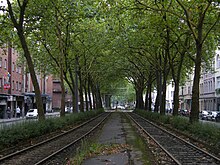
Since January 10, 1898, the foothills of the foothills , which was initially pulled by steam locomotives , had its terminus at Barbarossaplatz. Together with the tram of the Kölner Verkehrsbetriebe (KVB), the KBE foothills railway had its own route in the middle of Luxemburger Straße. The change of gauge from KBE's own narrow-gauge track (1000 mm) to normal track (1435 mm) began on February 20, 1914 and was not finished until October 7, 1934. At the end of the line, the KBE train station in Cologne Barbarossaplatz, a new reception building was opened on May 1, 1953, on three tracks that ended there. On January 1, 1955, the Cologne-Frechen-Benzelrath Railway merged with the KVB. The last day of operation at this station was on November 9, 1986. Since October 26, 1985, the route has been used exclusively by lines of the Cologne Stadtbahn . The “Marktbahn”, which opened on June 22, 1902, ran from the Süd Stadtbahnhof via Luxemburger Strasse and Weyerstrasse to the slaughterhouse.
Buildings and landmarks
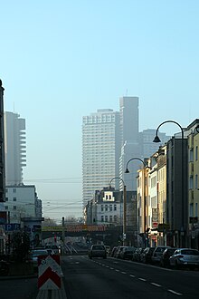
Along the Luxemburger Straße, a large proportion of the pre-war buildings have survived or have been rebuilt. To the south of the Südbahnhof , west of the street, are the scientific institute buildings of the University of Cologne in the inner green belt . One of the well-known residential buildings from the Wilhelminian era is house number 34 , which was built in 1886. All that remains of the building that was destroyed in the war are facade fragments that were integrated into the front of the brick building. The 105-meter-high Cologne Justice Center in No. 101 was ready for occupancy on April 30, 1981 and is the seat of the Cologne District and Regional Court and the Cologne Public Prosecutor's Office. Around 1700 employees work on an area of 64,000 m². The Employment Agency moved into a 14-storey office building (No. 121) in 1982, which was sold in July 2015 to the Cologne-based investor Art Invest for 15 million euros. In January 2018 the agency moved to Butzweilerhof , Butzweilerhofallee 1 (50829 Cologne).
The Y-shaped Uni-Center in No. 124-136, which is 134 meters high and 45 floors high, was occupied on August 1, 1973 and with 954 units is one of the largest residential buildings in Europe. The city's new archive building is to be built on the corner of the Eifelwall . 1. FC Köln was founded on February 13, 1948 in the former “Roggendorf” pub (No. 188) . The oldest building is the moated Weisshaus castle at no. 201, expanded in 1669 by Abbot Aegidius Romanus (1604–1684) of St. Pantaleon as a summer residence and rebuilt several times by 1953. The "Theater am Weißhaus", which opened on November 19, 1953 with 721 seats, is a cinema in No. 255. It was built in marble by the builder Heinrich Wolf (originally No. 253) and was one of the large cinemas outside of Cologne city center . Since 1959 it has 388 places. The “Haus Unkelbach” restaurant was located at Weyerstraße 112 from 1930, from 1943 at Luxemburger Straße No. 262, and after 1945 in the neighboring house No. 260. Klettenbergpark is part of Cologne's green belt . The Sozialverband Deutschland eV maintains the Cologne District Association in No. 378, followed by Carl Heymanns Verlag in No. 449 .
location
The Luxemburger Straße leading from the Cologne ring to the southwest is the federal highway 265 from Cologne to Prüm . At the intersection with Eifelwall and Luxemburger Wall, the street between the old town and suburbs forms a narrowing of the street. From here the street is designed as an avenue , with the trees south of Universitätsstraße being significantly older than the northern one. Important intersections are Moselstrasse, Luxemburger Wall / Eifelwall, Universitätsstrasse , Gottesweg, Kölner Gürtel and Militärringstrasse . It therefore crosses the road rings around Cologne on the left bank of the Rhine, such as a part of the new outer wall roads (since 1916). The junction 11a to the Kölner Ring with the federal highway 4 consists of the exit Köln-Klettenberg. In Cologne-Porz (Steinstrasse) there is also a small, only 74-meter-long Luxemburger Strasse (dead end).
literature
- Hiltrud Kier : The Cologne Neustadt: planning, development, use. - 1st edition - Düsseldorf: Schwann, 1978 - ( Contributions to architectural and art monuments in the Rhineland ; Volume 23), ISBN 3-590-29023-4 .
Individual evidence
- ^ Peter Hanstein, Publications of the Society for Rhenish History , Volumes 8-12, 1923, p. 100.
- ↑ a b Fred Kaufmann / Dagmar Ltz / Gudrun Schmidt-Esters, Cologne street names: Neustadt and Deutz , 1996, p. 91 f.
- ↑ A small side feeder at the beginning of Luxemburger Strasse still bears the name Trierer Strasse today
- ↑ Cologne Yearbook for Early History and Prehistory , Römisch-Germanisches Museum, 1989, p. 25.
- ↑ Hiltrud Kier, Die Kölner Neustadt: Planning, Development, Use , 1978, p. 158 f.
Web links
Coordinates: 50 ° 54 '45.1 " N , 6 ° 55' 26.9" E


