
Zülpich
| coat of arms | Germany map | |
|---|---|---|

|
Coordinates: 50 ° 42 ' N , 6 ° 39' E |
|
| Basic data | ||
| State : | North Rhine-Westphalia | |
| Administrative region : | Cologne | |
| Circle : | Euskirchen | |
| Height : | 180 m above sea level NHN | |
| Area : | 101.01 km 2 | |
| Residents: | 20,332 (Dec. 31, 2019) | |
| Population density : | 201 inhabitants per km 2 | |
| Postal code : | 53909 | |
| Primaries : | 02252, 02251, 02256, 02425 | |
| License plate : | EU, SLE | |
| Community key : | 05 3 66 044 | |
| LOCODE : | DE ZUE | |
| City structure: | Core city u. 24 towns | |
City administration address : |
Markt 21 53909 Zülpich |
|
| Website : | ||
| Mayor : | Ulf Huertgen ( CDU ) | |
| Location of the city of Zülpich in the Euskirchen district | ||
  |
||


Zülpich is a town in the Euskirchen district with 20,332 inhabitants, who are spread over the core town and 24 towns. The "Roman city" Zülpich with the Latin name Tolbiacum has existed since the 1st century BC. The battle of Zülpich in AD 496 is a well-established term in European historiography. Zülpich harbors a large number of historical cultural monuments, including the only German " Museum of Bathing Culture ".
geography
Zülpich is located in the Jülich-Zülpich Börde and is part of the Rhenish lignite mining area (lignite extraction in the Zülpich open-cast mine from 1953 to 1967). This is still reflected today in the two quarry ponds: the Zülpich water sports lake and the Füssenich nature reserve lake .
Neighboring communities / towns are clockwise: Weilerswist community , Euskirchen district town , Mechernich town (all in Euskirchen district), Heimbach town, Nideggen town, Vettweiß township (all in Düren district ) and Erftstadt (in the Rhein-Erft district )
City structure
The following table shows the location and the number of inhabitants of the localities and districts in the large municipality of Zülpich (as of December 31, 2018).
| Locality | Location (1) | Residents |
|---|---|---|
| Bessenich | west | 459 |
| Bürvenich | southern | 922 |
| Dürscheven | east | 503 |
| Enzen | east | 574 |
| Eppenich | southern | 135 |
| Fuessenich | west | 792 |
| Equal | west | 817 |
| Hoven with the place Floren | southern | 1102 |
| Juntersdorf | west | 227 |
| Langendorf | southern | 309 |
| Linzenich | east | 358 |
| Lövenich | east | 224 |
| Merzenich | southern | 167 |
| Mülheim | east | 383 |
| Nemmenich with the town of Lüssem | east | 761 |
| Niederelvenich | east | 564 |
| Oberelvenich | east | 218 |
| Rövenich | north | 489 |
| Difficulty with the place Virnich | east | 1605 |
| Sinzenich | east | 1252 |
| Ülpenich | east | 1134 |
| hamlet | north | 460 |
| Important | east | 966 |
| Zülpich (core city) | 6141 |
climate
|
Average monthly temperatures and precipitation for Zülpich
|
||||||||||||||||||||||||||||||||||||||||||||||||||||||||||||||||||||||||||||||||||||||||||||||||||||||||||||||||||||||||||||||||||||||||||||||||||||||
history
During excavation work in the “Seegärten” construction area in November 2009, finds that date from the Neolithic Age were brought to light . There are remains of equipment that settlers used in the 4th millennium BC. Until now it was assumed that the “Roman city” could look back on a history of only 2000 years. It is believed that as early as 5500 BC. First nomads settled in the Rhineland to settle down there.
In the 1st century BC Zülpich probably already existed as a small settlement. At the turn of the ages, Zülpich, the Roman Tolbiacum, became a small Roman town ( vicus ) . Important Roman highways to the following cities met in the city :
- Reims Durocortorum Remorum
- Trier Augusta Treverorum ( Römerstrasse Trier – Cologne )
- Xanten Colonia Ulpia Traiana (via Neuss Novaesium , Römerstraße Trier – Neuss )
- Bonn Castra Bonnensia (via Euskirchen-Billig Belgica Vicus )
- Cologne Oppidum Ubiorum / Colonia Claudia Ara Agrippinensium
- Jülich Iuliacum Vicus (regional connection)
The road connections from Reims and Trier met in the area of what is now the Hoven district and continued through the settlement towards Cologne. The route from Xanten, together with the road from Jülich, could have met the Trier / Reims-Kölner Strasse after a sloping incline on the slope to the Zülpicher Horst, also on the outskirts of Hoven. According to excavation findings in the area of today's Geriatric Center, the road coming from the east of Bonn met Cologne-Trierer Strasse south of Brabenderstrasse. Many of these roads are still recognizable today in the network of paths or in the field.
In the 2nd century a Roman thermal baths was built and in the 4th century a wall ring was built around the city center. In 496 the Alemanni were defeated by the Frankish King Clovis I in the Battle of Zülpich near Zülpich . After the battle, Clovis converted to Christianity and founded the Merovingian Frankish Empire . The Zülpich royal court had also been the center of the Zülpichgau since the Carolingian era , which belonged to the Ezzonen rulership until the 11th century .

The church of St. Peter is mentioned for the first time in 848. In 881, Zülpich was destroyed during the Viking raids in the Rhineland . Heinrich I , King of Eastern Franconia , conquered the city in 925. After this battle, Duke Giselbert of Lorraine submitted to Heinrich, and Lotharingen fell to Eastern Franconia.
City rights were granted in the first half of the 13th century. Between the years 1278 and 1285, the city was fortified by the Archbishop of Cologne, Siegfried von Westerburg . In 1288 the city was destroyed by Count Walram von Jülich . Under the rule of the Electorate of Cologne (finally since 1368) the city was rebuilt in 1395, a large part of which has been preserved to this day. At the beginning of the 15th century, the castle, the city wall and the gate systems were completed in their current appearance.
In 1635 the Capuchins founded a religious establishment with a grammar school in Zülpich, which later became a hospital. This still exists today as a geriatric center . In 1798, during the French era , Zülpich became the capital of a French canton after the Rhineland fell to France.
In 1864 the Bördebahn reached the city. In the 1930s, archaeologists discovered the very well-preserved Roman thermal baths.
On December 24, 1944, Zülpich was bombed by the Allies and large parts of the city center were destroyed.
In 1952 the new town hall was inaugurated and the foundation stone was laid for the reconstruction of St. Peter's Church . From 1953 to 1967 lignite was mined in the Zülpich opencast mine .
In 2007, Zülpich applied to host the 2010 State Horticultural Show in North Rhine-Westphalia, which, however, was awarded to the city of Hemer . With the modified concept "Zülpich Millennium Gardens - From Roman Times to the 21st Century", Zülpich again applied to host the State Garden Show 2014 and prevailed against the only competitor, Hamm .
Incorporations
On January 1, 1969, the former municipalities of Bessenich , Dürscheven , Enzen , Langendorf , Linzenich-Lövenich , Merzenich , Nemmenich , Oberelvenich , Rövenich , Sinzenich , Ülpenich , Weiler im Ebene and Wichterich were incorporated into the town of Zülpich. On January 1, 1972, Bürvenich , Füssenich and Schwerfen (district of Veytal ) were added.
politics
|
Local election 2014
Turnout: 49.52% (2009: 56.77%)
% 50 40 30th 20th 10
0
41.79%
25.44%
6.73%
8.15%
7.54%
6.28%
4.06%
no
Gains and losses
|
City council
The city council is the municipal representative body of the city of Zülpich. The citizens decide on the composition every five years. The last election took place on May 25, 2014.
mayor
The lawyer Ulf Hürtgen was elected mayor in September 2015.
Town twinning
Official town twinning
Unofficial town twinning
badges and flags
|
|
Blazon : "A continuous cut black bar cross in silver, covered with a heart shield, inside two diagonally crossed golden keys in red." |
| Justification of the coat of arms: The black cross in silver is the coat of arms of Kurköln , to which Zülpich belonged from 1278/1368 to 1798, the golden keys in red refer to the apostle Peter and his patronage over the church of St. Peter, first mentioned in 848. |

Description of the flag: "In white a black cross, covered with one, two crossed yellow keys, carrying a red shield."
The main statute gives no information about a flag. According to information from the municipal administration, a coat of arms flag is used.
religion
There is evidence that Jews have lived in Zülpich since the 13th century. Before 1933, the Jewish community with 150 members was significantly larger than the Protestant church community . No Jews have lived in Zülpich since the Holocaust .
traffic

The Zülpich station was built in 1864 by the Rheinische-Eisenbahn-Gesellschaft on the Düren – Euskirchen line and had connections to the Düren and Euskirchen district railways , because the transfer station was located there between 1908 and 1962. In 1959 the EKB ceased operations in Zülpich, followed by the DKB in 1963. Passenger traffic on the Bördebahn ceased on May 27, 1983.
After that it became quiet in the Zülpich train station. The station building has been preserved alongside the rented storage shed. The signal box Zf has been renovated and has been used by IG Rurtalbahn since 2007. Since 2006, trains of the citizen's railway from the Bördeexpress have stopped at Zülpich station on weekends , where the platform has since been renewed. From 2018 the line will also run during the week, from 2020 every hour.
Culture and sights
tourism
Zülpich is assigned to the Eifel tourist region . The slightly hilly landscape with its stream meadows, nature conservation and water sports lake offers good recreational opportunities for riders, cyclists and hikers. Zülpich is connected to a number of cycle paths . The 524 km long moated castle route connects more than 130 castles on the edge of the Eifel and in the Cologne Bay . The 265 km long cycle path network of the valley route opens up interesting tourist spots in North Rhine-Westphalia on a family-friendly route. The 480 km long Kaiser route runs from Aachen to Paderborn . It is named after Emperor Charlemagne , who resided in Aachen. The route is based on the presumed route that the imperial army took in 775 on its crusade into the Saxon territory .
State Horticultural Show 2014 / Gartenschaupark Zülpich

From April 16 to October 12, 2014, the North Rhine-Westphalian State Garden Show 2014 was held in Zülpich.
After the end of the state horticultural show on October 12, 2014, the Zülpich garden show park is the successor solution for large parts of the former garden show grounds.
Motorhome port
A mobile home port with 25 parking spaces is located almost directly on the southern bank of the Zülpich water sports lake .
Water sports lake
The 85-hectare water sports lake is located in the south-east of the city and was created in the 1970s when a former brown coal mine was flooded .
Neffelsee
The Neffelsee is a nature conservation lake, is located southwest of Zülpich, just before the village of Füssenich , and also comes from a former lignite mine.
Architectural monuments
St. Peter's Church
.JPG)
.jpg)

The church was first mentioned in a document by Wandalbert von Prüm in 848. In the 11th century the Benedictine Abbey of St. Michael in Siegburg received the patronage right to St. Peter from the Archbishop of Cologne. During this time the church was rebuilt in the Salian-Romanesque style. Over the years it has been rebuilt and expanded several times. It was completely destroyed in the Allied bombing raid on December 24, 1944. The foundation stone for the reconstruction was laid in 1953. The plans for the new building come from Karl Band. The extent and height effect are based on the previous building. However, the main room is rotated 90 degrees and faces south. The church was completed in 1955 and consecrated two years later, after the free-standing tower was completed. Numerous stones from the previous building can be seen in the walls. Particularly noteworthy are the Antwerp shrine altars, which contain depictions of saints related to Zülpich. It can therefore be assumed that these are commissioned works by civil institutions. The larger one is probably the commission of the Matthias Brotherhood and the butcher guild. Also noteworthy are the neo-Gothic confessionals and the Romanesque crypt on the left of the chancel. It is the only room that survived the destruction of the old church. It is praised as one of the most beautiful Salian lower churches in the Rhineland and consists of two almost identical room parts that are separated by a row of pillars and each comprises three naves with four bays. It contains two altars from the 19th and 20th centuries. The church treasure with works from the Baroque period can be admired in a wall niche. Including a cross reliquary and an impressive sun monstrance 72 cm high. Furthermore, a Cologne crucifix from around 1060, a baptismal font made of bluestone from the 12th century and the "Erper Madonna", which was previously a pilgrimage destination, from 1450 can be found in the new church. The new freestanding bell tower contains 64 square window openings and is the tallest building in the city. An impressive organ with trumpeteria from the manufacturer Orgelbau Weimbs from Hellenthal rests above the new baptistery. The plant was converted to a purely electrical control. The gaming table is in the Anno chapel. It contains 47 registers, divided into three manuals and pedal.
State castle from the 14th century

The first castle on this site was illegally built by the Jülich Count Palatine. From Archbishop Friedrich III. Jülich Castle was demolished from Saar Werden and today's castle was built in its place in the middle of the 14th century. The location of the castle, which is atypical for the Middle Ages, on a relatively flat terrain, sloping only to the north, is explained by the fact that the castle was built on the foundations of the former Roman fort and subsequent fortifications. The previous castle was destroyed during the Norman invasions in the 9th century.
The castle suffered severe damage during the Thirty Years' War and Louis XIV's predatory wars . After being rebuilt, it fell into disrepair in the centuries that followed. In 1741 it came into private ownership. From 1870 it was home to a schnapps distillery until it was badly damaged again in 1944 bombings. After the Second World War, the medieval outer walls and the factory in the inner courtyard were rebuilt.
At the end of the 1970s the distillery was sold to Maywerke and production in Zülpich ceased, and the castle began to fall into disrepair again. It was only at the beginning of the 21st century that the castle could be sold to private investors. After renovation, these furnished private apartments and commercially usable rooms. Since 2009, the Zülpich history association has occupied part of it with a history workshop. There is an information point for tourists and those interested, and the association also holds a small Christmas market inside the castle on the first weekend in Advent.
In 2013, the east tower of the Landesburg was expanded into a lookout tower.
town hall
The medieval town hall was destroyed except for the town hall tower. The foundation stone for the new town hall was laid in 1950, but not in the old location, but to the left of the post office building, in the middle of the market square. The city officials were able to start work in the new house in 1952. But over time it became too small, and so the modern town hall was added to the existing one in 1982.
Town hall tower

The post-Gothic tower was probably built between 1722 and 1725. Each councilor had to “donate” a glass window at his own expense in 1726, for which he was “rewarded” with 1/4 wine by the mayor. For several years there has been an Italian restaurant in the town hall tower.
city wall
Zülpich still has an almost complete city wall, which is rare in the Rhineland. It surrounds the city center. This medieval curtain wall is partly on the remains of a Roman wall. It was built in the 14th century together with the four city gates. On the city wall - at the Frankengraben - a piece of the Roman aqueduct that led from the Eifel to Cologne was exposed in 1979 in Mechernich - Breitenbenden and then erected in Zülpich . It can now be found in the Seepark.
City gates

The Kölntor

The stream gate

The Weiertor
The minster gate


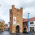
Kölntor
In the course of the city fortifications at the end of the 14th century, the east gate of the city was built at the end of the street of the same name to Cologne as a so-called double gate, that is, through the first gate (angular porch with battlements) one got into a courtyard ( kennel ) to get through the second, higher main gate (inner gate) to get into the city. This should make it difficult for the enemy to penetrate. In 1886 it was enlarged and the archway was raised. But the traffic increased more and more and the city wall attached to the gate had to be broken through. During the Second World War, the Kölntor was fitted with concrete anti- tank barriers , which are still visible today. The war damage was very high here, and so the walls were repaired between 1949 and 1953. An extensive restoration was carried out by the carnival society Blaue Funken . In cooperation with the city and the state curator, she set up a guard room in the gate.
Bach gate
It was built in 1393, also as a double gate system at the end of Bachstrasse in the north towards Bergheim and the Netherlands. Here the entrance gate, shown on an engraving from 1746 as a crenellated entrance gate without round towers (similar to the Cologne Gate), was removed around 1900 due to the increasing traffic. The city wall reached up to the gate. Later, again because of the traffic, it was breached. Today the street layout of the Bachstraße (K 82) named after the gate runs west of the gate.
Weiertor

The western city gate to Düren, generally known as the “most beautiful of the Zülpich gates”, was also built as a double gate at the end of the 14th century. It was largely destroyed in bombing raids. The actual main gate, a rectangular gate tower with a crenellated wreath similar to the Bachtor, no longer stands, only the left round front tower survived the war. The right tower was only rebuilt in 1974.
Minster gate
The Münstertor was built in 1357 as the first of the city gates at the southern end of the street of the same name and led to the country road to Bad Münstereifel . On the engraving from 1746 (Zülpich's medieval townscape on a drawing from the early modern period) the Münstertor is shown with a front gate similar to the Bachtor, including the two round towers on the flanks. Due to the high volume of traffic, the city wall at the gate had to be removed. The minster gate was also badly damaged in the war. The crenellated corner observatories , which it had as the only gate, were not restored until 1976. During earthworks for the roundabout completed in 2012, the foundations of a double gate system were found. This confirmed the representation on the engraving from 1746. Like the Kölntor, the Münstertor is home to a carnival society, the Prinzengarde . The problem with the expansion to the guardroom was the staircase. It was soon agreed on the variant of a steel structure next to the tower, as it is visible today.
Martinskirche

The church was located in the 12th century on today's Römerallee, near the cemetery. Archbishop Siegfried von Westerburg had it torn down and rebuilt at its current location in 1279. Since the secularization in 1802, it has been used variously as a warehouse and residence. In 1952 the church burned down completely. In 1997, the conversion of the church into a community meeting place was completed.
Roman thermal baths
On the Mühlenberg, in the immediate vicinity of St. Peter's Church, there are Roman thermal baths from the 2nd century. They are considered to be the best preserved ruins of this type north of the Alps. Today they are integrated into a museum of bathing culture .
House Spitz
Haus Spitz is a representative country house with a large landscaped park. It was the home of the paper manufacturer Heinrich Xaver Sieger .
Bath culture museum

The Museum of Bathing Culture was built above the Roman-era thermal baths on Mühlenberg from 2004 according to plans by the Zülpich architect Markus Ernst and opened in September 2008.
History workshop
After the integration of the premises of the former Heimatmuseum Zülpich in the old Propstei am Mühlenberg into the Museum of Bathing Culture, from 2009 to October 2011 most of the exhibition holdings of the old Heimatmuseum were transferred to the newly created history workshop. The premises are located in the Electorate of Cologne, which is also located on Mühlenberg. Contrary to ideas possibly based on derivations from the name history workshop, this is a completely normal museum about the city history of Zülpich and not a research facility or a creative project. The sponsors of the museum are the city of Zülpich and the Zülpich history association on a voluntary basis.
Women's education center Zülpich
In 1979, the Zülpich women's education center in the Lövenich district opened the first conference center in Germany dedicated exclusively to women's education .
Personalities
Historical personalities
- Michael Küll (1693–1732) Abbot of the Steinfeld Monastery
Honorary citizen
- Hubert Salentin , born January 15, 1822 in Zülpich; † July 7, 1910 in Düsseldorf, painter
- Joseph von Ayx , born August 20, 1838 in Münstereifel; † August 27, 1909 at Zievel Castle near Euskirchen, district administrator
sons and daughters of the town
- Ferdinand von Hompesch zu Bolheim , born November 9, 1744 in Oberelvenich, † May 12, 1805 in Montpellier, Grand Master of the Order of Malta
- Johann Peter Weidmann , born July 27, 1751 in Zülpich; † June 23, 1819 in Mainz, doctor and university professor
- Ludwig Sieger , born September 27, 1857 in Zülpich; † November 15, 1952 in Gladbach, General
- Theodor Weber , born January 28, 1836 in Zülpich; † January 12, 1906 in Bonn, bishop
- Thomas Eßer , born May 15, 1870 in Schwerfen; † November 29, 1948 in Euskirchen, editor and politician
- Karl Sieger , born August 27, 1883 in Zülpich; † June 23, 1961 in Gladbach, district administrator
- Christel Jenniches , born October 14, 1937 in Nemmenich, † February 28, 2011, German amateur singer
- Theo Breuer , born March 30, 1956 in Bürvenich, writer and editor
- Thomas Scheidtweiler , born July 13, 1964 in Zülpich, agricultural engineer and science manager
- Oliver Krischer , born July 26, 1969 in Zülpich, biologist and politician (Bündnis 90 / Die Grünen), member of the German Bundestag
- Hans Jörg Hennecke , * 1971 in Zülpich, political scientist and economic functionary
Persons connected to Zülpich
- Kai Meyer , born July 23, 1969 in Lübeck, author, grew up in Zülpich
- Silke Rottenberg , born January 25, 1972 in Euskirchen, former national soccer player, grew up in Zülpich
- Hans Biermann , born November 23, 1954 in Lünen, doctor and publisher, lives in Zülpich
useful information
- A street in Paris, the Rue de Tolbiac , and a bridge, the Pont de Tolbiac , and a metro station are named after Zülpich (French: Tolbiac) . There are also some other streets and squares named after Zülpich, mainly in the Rhineland, including in Cologne , Bonn , Düsseldorf and Düren .
- Until the end of the 19th century, viticulture was also carried out on the Neffelbach in Zülpich .
- There was a Jewish cemetery in Zülpich , the dead of which were reburied in the Jewish cemetery in Cologne-Ehrenfeld in 1958 .
literature
- Tolbiacum. In: Reallexikon der Germanischen Altertumskunde . (RGA)
- Heribert van der Broek: 2000 years Zülpich. Zülpich 1968.
- Paul Clemen (ed.): The art monuments of the district of Euskirchen. Schwann, Düsseldorf 1900 (with contributions to Zülpich and Hoven).
- Hans-Gerd Dick: Zuelpich. (= Rheinische Kunststätten , issue 552). Rhenish Association for Monument Preservation and Landscape Protection , Cologne 2014, ISBN 978-3-86526-103-8 .
- Dieter Geuenich , Thomas Grünewald , Reinhold Weitz (eds.): Chlodwig and the battle near Zülpich. History and Myth 496–1996 . Book accompanying the exhibition in Zülpich August 30 to October 26, 1996. Euskirchen 1996, ISBN 3-9802996-7-8 .
- Paul Heusgen: History of the parishes of the Deanery Zülpich. Siegburg 1958.
- Dieter Kastner (edit.): The judges' book of the city of Zülpich and the documents of the city archive. Cologne 1996, ISBN 3-7927-1591-0 . (with a contribution to the medieval town and legal history of Zülpich.)
- Sabine Philipp: Parish Church of St. Peter Zülpich. Schnell & Steiner publishing house, Regensburg 2002, ISBN 3-7954-6302-5 .
- Martin Seidler: St. Peter in Zülpich. (= Rheinische Kunststätten. Issue 553). Rhenish Association for Monument Preservation and Landscape Protection, Cologne 2014, ISBN 978-3-86526-104-5 .
Web links
- Website of the city of Zülpich
- Portal with a lot of information about Zülpich
- Sound sample of the Zülpich dialect on the website of the language department at the Institute for Regional Studies and Regional History at the Rhineland Regional Council
Individual evidence
- ↑ Population of the municipalities of North Rhine-Westphalia on December 31, 2019 - update of the population based on the census of May 9, 2011. State Office for Information and Technology North Rhine-Westphalia (IT.NRW), accessed on June 17, 2020 . ( Help on this )
- ↑ The place name Tolbiacum is of Gallic descent * Tolbiākon
- ↑ zuelpich.de
- ↑ Inconspicuous, but extremely valuable. ( Memento from July 31, 2012 in the web archive archive.today ) In: Kölner Stadt-Anzeiger. November 24, 2009.
- ↑ Martin Bünermann: The communities of the first reorganization program in North Rhine-Westphalia . Deutscher Gemeindeverlag, Cologne 1970, p. 88 .
- ↑ Martin Bünermann, Heinz Köstering: The communities and districts after the municipal territorial reform in North Rhine-Westphalia . Deutscher Gemeindeverlag, Cologne 1975, ISBN 3-555-30092-X .
- ^ City of Zülpich. European / Local elections 2014. May 25, 2014, accessed October 30, 2014 .
- ↑ Main statute of the city of Zülpich, § 2. (PDF; 160 kB) (No longer available online.) Archived from the original on January 21, 2016 ; accessed on January 21, 2016 .
- ↑ Joachim Sprothen: In Zülpich there were more Jews than Protestants. In: ksta.de . November 11, 2001. Retrieved July 30, 2019 .
- ↑ Tom Steinicke: From the end of 2020 every hour from Euskirchen to Düren - Bördebahn should run daily. In: Kölnische Rundschau . December 1, 2016, accessed February 19, 2017 .
- ↑ Motorhome port. Seepark Zülpich, accessed on November 2, 2019 (German).
- ↑ www.eifel.de - Sights: Roman aqueduct. Retrieved January 2, 2010 .
- ↑ History workshop : Now the heart is complete. In: Kölnische Rundschau . October 12, 2011, accessed June 15, 2014 .
Bad Münstereifel | Blankenheim | Dahlem | Euskirchen | Hellenthal | Kall | Mechernich | Nettersheim | Schleiden | Weilerswist | Zülpich
Bessenich | Bürvenich | Dürscheven | Enzen | Eppenich | Füssenich | Equal | Hoven and Floren | Juntersdorf | Langendorf | Linzenich | Lövenich | Merzenich | Mülheim | Nemmenich | Niederelvenich | Oberelvenich | Rövenich | Schwerfen | Sinzenich | Ülpenich | Hamlet in the plain | Important