
Oberelvenich
|
Oberelvenich
City of Zuelpich
Coordinates: 50 ° 42 ′ 1 ″ N , 6 ° 42 ′ 29 ″ E
|
|
|---|---|
| Height : | 145 m |
| Area : | 3.13 km² |
| Residents : | 218 (December 31, 2018) |
| Population density : | 70 inhabitants / km² |
| Incorporation : | 1st July 1969 |
| Postal code : | 53909 |
| Area code : | 02252 |
Oberelvenich is a district of Zülpich in the district of Euskirchen , North Rhine-Westphalia . The mayor is Hans von Hagenow (as of January 2018).
location
Oberelvenich is located in the Zülpicher Börde east of Zülpich. Neighboring towns are Nemmenich , Rövenich , Niederelvenich and Frauenberg , a district of Euskirchen . On the western edge of the shuttle runs to the A 1 , through the town leads highway 162. The village lies at Rotbach .
history

The place was first mentioned in the year 843. At that time the village was called Elvenich . Only after Niederelvenich was created was the place renamed Oberelvenich .
Bollheim Castle was often the base for soldiers . It was not until the French occupation after 1794 that the rulers lost their influence on the castle . Today there is an organic farm on Haus Bollheim . There was also the submerged Elvenich Castle in the village .
At the Rotbach there are two mills , a grain mill and an oil mill. They used to be used to supply Haus Bollheim. Today they are privately owned.
On July 1, 1969, Oberelvenich was incorporated into Zülpich .
church
Oberelvenich belongs to the North-West Parish Association, as do the places Niederelvenich, Rövenich, Mülheim and Wichterich. The parish church is under the patronage of St. Matthias .
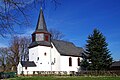
St. Matthias, south side

Rococo altars

Baptismal font (12th century)

High altar

Madonna (14th century)
_01.jpg)
_04.jpg)
_11.jpg)
_05.jpg)
_12.jpg)
Web links
Individual evidence
- ↑ Population figures as of December 31, 2018
- ↑ Martin Bünermann: The communities of the first reorganization program in North Rhine-Westphalia . Deutscher Gemeindeverlag, Cologne 1970, p. 88 .

Bessenich | Bürvenich | Dürscheven | Enzen | Eppenich | Füssenich | Equal | Hoven and Floren | Juntersdorf | Langendorf | Linzenich | Lövenich | Merzenich | Mülheim | Nemmenich | Niederelvenich | Oberelvenich | Rövenich | Schwerfen | Sinzenich | Ülpenich | Hamlet in the plain | Important