Merzenich (Zuelpich)
|
Merzenich
City of Zuelpich
Coordinates: 50 ° 40 ′ 2 ″ N , 6 ° 38 ′ 2 ″ E
|
|
|---|---|
| Height : | 181 m |
| Area : | 2.26 km² |
| Residents : | 167 (December 31, 2018) |
| Population density : | 74 inhabitants / km² |
| Incorporation : | 1st July 1969 |
| Postal code : | 53909 |
| Area code : | 02252 |
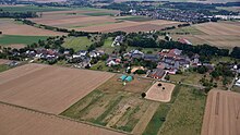
Merzenich is a district of Zülpich in the district of Euskirchen , North Rhine-Westphalia .
geography
location
Merzenich is about 2.4 km south of the city in the Zülpicher Börde on the edge of the Voreifel . The place Zülpich is at the fork in the Heerstraße Cologne - Zülpich - Trier - Reims .
history
Merzenich comes from Roman times. The place used to be called Martiniacum . In the course of time it became Merzenich . The village was first mentioned in 1140 because a local nobleman Brunste von Mercinich had payment obligations to the church in Zülpich. There used to be a castle in Merzenich. The last owners of the castle were the noble lords of Schaesberg . As early as 1723, however, the castle no longer appears in the description of the noble seats ( Codex Welser ).
On July 1, 1969, Merzenich was incorporated into Zülpich .
traffic
Zülpich-Merzenich was on the so-called Eifel route of the Euskirchener Kreisbahnen .
church
The Catholic parish of St. Severin always been one of Zülpich. Today it forms a community with five other parishes.
Individual evidence
- ↑ Population figures as of December 31, 2018
- ↑ Martin Bünermann: The communities of the first reorganization program in North Rhine-Westphalia . Deutscher Gemeindeverlag, Cologne 1970, p. 88 .


