
High Gate (Cologne)

The high gate ("porta alta" or "porta Jovis") was the southern gate of the Roman city wall in the south of Cologne's old town , through which the " cardo maximus " ran. Today the street Hohe Pforte is named after this gate .
goal
The Roman city wall had nine gates through which the Roman roads ran. In north-south direction this was the "cardo maximus" with a width of 20 Roman feet (5.92 meters), at whose endpoints the Pfaffenpforte (to Neuss = Novaesium ) and to the south the Hohe Pforte (to Bonn = Bonna) found. There was a small hill here from which the elevated gate got its name.
location
The 903.30 meter long south wall ran along the Duffesbach below the northern row of houses on the Mühlen- and Blaubach streets and ended at the Greek gate - which was only built in the 10th century on a wall breakthrough ; the distance between the two gates was more than a kilometer. The only gateway in the south was the Hohe Pforte. It was therefore at the current intersection of Hohe Pforte / Am Blaubach. Here the military road from Mainz to Xanten reached the city and ran through it as "cardo maximus". After 400 meters it came to the signal flag "under the four winds" (see Hohe Straße ), after another 400 meters you reached the Pfaffenpforte.
history
The chronology and building history of the first ancient Cologne city fortifications are uncertain. In any case, it must have been completed before the year 69 AD, since Tacitus mentions it in his histories when describing the Batavian rebellion (69-70 AD). The Tenkerer are said to have demanded its destruction, but not achieved it. Their foundations were 2.66 meters wide and 2.50 meters high. The exact location of the south gate could have been the front part of the house Hohe Pforte No. 4, because it was built on a gate pillar of the south gate, the foundation masonry of which is said to have been found under the paving of the cellar. After excavations in February 2008, the shuttering boards of the concrete foundation on the east side were dendrochronologically dated to 89 AD .
Towards the evening of January 1, 69 AD, the cavalry of the Legio I Germanica , coming from Bonn, rode through the south gate under the command of their legate Fabius Valens to emphasize the elevation of the governor Aulus Vitellius to emperor . On January 2, 69, Vitellius was proclaimed emperor in the city.
Fate of the gate
The Roman south gate was attested in the middle of the 12th century as "altea Porta", in the 13th century it was called "hoinporce". The internationally active Cologne wine merchant Arnold Ungenoth (Ungenüg) owned a stone house ("domus") here in 1232. The south gate can be found for the last time in the shrine books in 1301 and was not mentioned again in the following centuries. Wilhelm Scheben thinks it possible that it was demolished in 1497 because material was needed to improve and increase the Rhine wall. In any case, the gate is no longer shown in Arnold Mercator's Cologne cityscape from 1570 , but its northern counterpart Pfaffenpforte is. Hermann von Weinsberg , who has lived at the south gate since 1555, suspected that the “Torn” (tower) was “villicht vurmails of the old town gates or wich house and was built”. When the canal was built at the high gate in 1868, the Roman wall there had to be largely broken.
Street
The street name Hohe Pforte still reminds of the southern Roman city gate.
middle Ages


Traces of the Roman city wall can be recognized by old Cologne street names such as Obenmarspforten, Greekspforte and Hohe Pforte. The section of the “cardo maximus” at the height of the Hohe Pforte was initially called “via alta” - the Hohe Straße. The street and the south gate often changed their names, depending on the language development. In the early Middle Ages they were called "Huhpooz", in the 15th century also "up der hoeportzen", in Arnold Mercator 1570 "Auff der hochpforts", in the 2nd half of the 16th century "over the Houpfotz" or in Hermann von Weinsberg " Hochpforte ”and then in the 17th century finally“ uf der Hawportzen ”. The Stephanskapelle was later in No. 24 opposite the Sternengasse , was consecrated in 1009 by Archbishop Heribert of Cologne and is therefore the earliest consecrated chapel in Cologne; it was canceled before 1893.
The sphere of activity of the Cologne councilor Hermann von Weinsberg was in the area Waidmarkt / Blaubach and Hohe Pforte. “I now have my apartment in Kronenberg on the Hochpforte.” The back door opened the entrance to “Haus Weinsberg” (letter S on Weinsberg's drawing), where his widowed mother lived. Weinsberg owned the "Vulappelhaus" in No. 3 here since 1555, which he had rebuilt in 1585 and now called "zur Trauben". The neighboring "Haus Cronenberg" had belonged to him since his wedding to Druitgin and he had it rebuilt in May 1573 after the death of his wife. Cronenberg was the nickname of the Cologne doctor Bernard Deffenius (Cronenburgius), who lived between 1510 (* in Amsterdam ) and 1574 († in Cologne). Here he wrote the text “De compositione medicamentorum” in 1555, and in 1565 published a “Cologne Pharmacopoeia” on behalf of the city council. On November 27, 1581, Weinsberg sold the house “zum Gülich” on the corner of Waidmarkt for 2,200 thalers. Chronicler Weinsberg reports that on June 6, 1591, the city's path makers began building a bridge over the open stream.
The entry route of the Archbishops of Cologne led in the Middle Ages through the Severinstor over the Severinstrasse and the Waidmarkt through the Hohe Pforte and further over the Hohe Strasse through the Pfaffenpforte to Trankgasse in the courtyard of the Mariengraden Abbey .
Founding times and modern times
- New mansion house after renovation

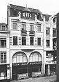
Hohe Pforte 8 - Haus zum Grin, Lölgen Brewery (around 1900)
Hohe Pforte 22 - residential and commercial building (around 1900)

Hohe Pforte 25–27 - Herstatt Bank (around 1900)

Hohe Pforte 2a - from the Waidmarkt (around 1914)

Hohe Pforte 2a - residential and commercial building (March 2012)

Hohe Pforte 9–11 - Hochpfortenhaus (September 2012)


The Cologne court banker Johann Heinrich Sybertz (or Siebertz) lived in nos. 23-25, who in 1705 issued the first German paper money of the electoral bank Banco di gyro d'affrancatione in Cologne and redeemed it at “Cölln auf der Hohen Pforten”. He owned the house designed by master stonemason Sylvester Heukeshoven "zum Roten Giebel" (No. 23-25) at the latest since May 18, 1706, on March 24, 1749, his heirs acquired the house. Isaak Herstatt bought it in 1758, and in 1782 the Herstatt bank moved in here under the direction of Johann David Herstatt. On May 10, 1798, ownership in the shrine books passed to the couple "Banquier Johann David Herstatt and Adelaide von der Leyen" after the restriction on property acquisition by people of different faiths no longer existed in March 1798. Herstatt had it completely rebuilt in the classicistic style in 1813, expanded in 1860 and furnished inside in the style of the nobility. In the address book of 1797 the building is referred to as "silk, floret, ribbon factory and bills of exchange". According to the address book from 1848, the writer Georg Weerth lived in No. 21, the writer Adele Gerhard was born on June 8, 1868 in No. 17. The house "zum Grin", which had already been badly damaged by the air raid of June 19, 1943, was in No. 6–8. No. 16 "Zum Jütgin" was extensively rebuilt in 1790 and destroyed in air raids on May 31, 1942.
The Bank-Lölgen brewery was located in No. 8 and is considered the place where the Rhenish specialty Halver Hahn was invented . Next door in No. 10 opened on May 26th 1906 with the "Biograph Theater", the first Cologne cinema, but it closed its doors in 1914. In no. 2a, the architects Helbig & Klöckner built a residential and commercial building in 1914, into which the "Café Prinzess" moved unusually on the first and second floors. The café became the gay bar Barberina-Bar (named after the dancer Barberina Campanini, 1721–1799), one of the most famous night bars in Cologne, where gays, male and female prostitutes, pimps, petty criminals and artists met. Between 1949 and 1954, Trude Herr waited here for the landlord Jean Rosen . The Hohe Pforte was always popular for bars, because in 1961 the Café Wüsten settled in No. 23-27 , followed in 1968 by the Four Zipps in No. 13-17.
The old Herstattbank was taken over by the JH Stein bank in March 1888 , and the Herstatt family then used the Herstatt house as a residential and commercial building; it was demolished in 1929 as part of the family ownership streamlining. The new "Herstatthaus" was built in its place in today's No. 29 / corner of Sternengasse in 1931. The builder was the banker Artur Deichmann, married to Stefanie Deichmann, b. Herstatt. The houses at Sternengasse 1, 1a and 1b are still owned by this family today. The so-called “Hochpfortenhaus” at No. 9–11 / Agrippastraße 1–5 by Clemens Klotz was built in 1930 in a steel frame construction with a stepped facade with a ribbon-like, horizontal layering of the facade. In addition to the Disch-Haus, it is an important contribution to the New Building in Cologne. Between 1947 and November 1953, this was where the head office of the Stadtsparkasse Köln was located , and since 1967 at the latest the state supply office in North Rhine-Westphalia. The building has been a listed building since April 3, 2000, and 46 condominiums were built here in May 2005.
location
The “Hohe Pforte”, which is only 147 meters long, begins at Blaubach / Mühlenbach and ends at the intersection of Sternengasse / Stephanstraße, where Hohe Straße continues to the north . The only access roads are the Hochpfortenbüchel (where the hilly location can still be recognized), Agrippastraße and Sternengasse / Stephanstraße.
Linguistic
The Hohe Pforte, just like the Alter Markt , is not inflected , contrary to the language used . The street name is pronounced with an emphasis on "high".
Individual evidence
- ↑ after Leonard Ennen , sources on the history of the city of Cologne , Volume 1, 1863, p. 76
- ↑ DuMont Schauberg, Ferdinand Franz Wallraf : Collection of contributions to the history of the city of Cologne and its surroundings , 1818, p. 11
- ↑ Gerd Biegel, Cologne , Volume 1, 1980, p. 65
- ^ Gerta Wolff, The Roman-Germanic Cologne: Guide to Museum and City , 1984, p. 146
- ↑ Otto Doppelfeld, Vom Unterirdischen Köln , 1979, p. 37
- ↑ Joachim von Elbe, The Romans in Germany: excavations, sites, museums , 1977, p. 136
- ↑ Hist IV cap. 64 and cap. 65
- ↑ Michael Mertz, contribution to the determination of the location and the current condition of the Roman wall in Cologne , 1883, p. 3
- ^ Carl von Veith, The Roman Cologne , 1885, p. 14
- ↑ Michael Mertz 1883, p. 15
- ↑ Joachim von Elbe 1977, p. 136
- ↑ Natalie Fryde, A Medieval German Large Entrepreneur , 1997, p. 32
- ^ Wilhelm Scheben, The former gateways of old Cologne , 1895, p. 23
- ↑ Josef Stein, Das Buch Weinsberg: Cologne Memories from the 16th Century , 1962, XI, XXVII
- ^ Marion Werner, From Adolf-Hitler-Platz to Ebertplatz , 2008, p. 279
- ^ Leopold Ennen in: Zeitschrift für Kulturgeschichte, Volume 1, 1872, p. 561
- ^ Matthew Lundin, Paper Memory: A Sixteenth-Century Townsman Writes His World , 2012, p. 249
- ↑ Helmut Signon / Klaus Schmidt, all roads led through Cologne , 2006, pp 188 et seq.
- ^ Friedrich Lau, Das Buch Weinsberg , Volume IV, 1898, p. 119
- ↑ Peter Johanek / Angelika Lampen, Adventus: Studies on the rulers' entry into the city , 2009, p. 43
- ^ Albert Pick, Paper Money: A Handbook for Collectors and Lovers , 1967, p. 135
- ↑ Robert Steimel, JD Herstatt - the old and the new banking house , 1963, p. 11
- ^ Hugo Stehkämper, History of the City of Cologne , Volume 8, 2005, pp. 304 f.
- ^ Eduard Trier / Willy Weyres, Art of the 19th Century in the Rhineland: Architecture II, Profane Buildings and Urban Development , 1979, p. 257
- ↑ Michael Vogt, Georg Weerth and the feature section of the Neue Rheinische Zeitung , 1999, p. 184
- ↑ Petra Leser, The Cologne Architect Clemens Klotz , 1886–1969, Volume 1, 1991, p. 109
Coordinates: 50 ° 55 '58.9 " N , 6 ° 57' 22.6" E