
Cologne brooks

The creeks , dialect and originally for the entire course also de Baach , now form a street in Cologne . The name goes back to the Duffesbach , which was formerly also known as Hürther Bach .
prehistory
Even before the Roman Cologne, the then CCAA, Colonia Claudia Ara Agrippinensium , received the status of a provincial capital in 89 AD and the long Roman Eifel aqueduct was built, the Duffesbach with its Hürth spring streams supplied the city as a "Hürth line" fresh drinking water. After the pipe fell into disrepair in post-Roman times, the watercourse remained as a stream. It then served the urban trades on its banks and the adjacent vineyards for water supply. He was also the namesake of many of the streets in the medieval city.
The namesake


The Duffesbach, which rises near Hürth-Knapsack (local location: former Knapsacker train station), today mainly flows underground and canalised, crosses the Hürth districts of Alt-Hürth , Hermülheim and Efferen and meets the Cologne urban area on the other side of the A 4 in Cologne-Sülz . It then flows through the Cologne-Klettenberg district and reaches downtown Cologne at the height of the Eifelwall. Nowadays, the stream continues to flow for a length of five kilometers in a pipeline to the Rhine. The piping was the subject of a renovation in 2008 by the Stadtentwässerungsbetriebe Köln AöR .
The brooks in old Cologne

The watercourse of the Duffesbach was simply called “de Baach” in early Cologne, the streets accompanying it were often only called “up de bach”, “op der Baach”, Latin “in ripa” (in, on the creek bank). Later differentiations or official names in Mühlen-, Blau-, Rot (h) gerber- and Weidenbach or Bachstraße were only made under French administration in the years 1812/13. At the suggestion of Professor Ferdinand Franz Wallraf , the renaming was based on the historical background of the respective name. The German names after French rule followed in the same way. The street names that are still valid today mark his further path:
Duffesbach

The street "Am Duffesbach" lies between the Eifelplatz and the Salierring in what is now Cologne's Neustadt-Süd district .
The name Duffesbach is derived from a mill located on it, called "tuifhaus". This name is also used as a field name on a hand-drawn map from the second half of the 16th century.
Weidenbach

The street “Am Weidenbach”, formerly also called Bachstraße, now runs between Salierring and “Neue Weyerstraße”. Here, behind the wall and the “Bachtor”, the Duffesbach reached fortified imperial urban area. (The third medieval city expansion was completed in 1259).
The Weidenbach also crosses the "Wallstraßen", the paths that used to run directly behind the city wall, here Pantaleon and Carthusian walls. The "Pantaleonstor" was part of this city fortification between the "Bachtor" and the Ulrepforte on the Carthusian Wall. It was walled up as early as the 16th century, probably in connection with war events. In the 18th century it was provided with a 30 meter high tower and then served as a mill. The building was demolished around 1883.

In the Middle Ages, the road ran as a "waterway" from the Bachtor (mill since 1730), beginning in the old southern city wall to Weyerstraße. A pond-like damming of the Duffesbach was created by the semi-flat terrain within the fortification, before the terrain slopes slightly from the Pantaleonsberg over the Rot (h) gerberbach towards the Rhine. The Weidenbach with its bank area is called "bacstraze" (Bachstraße) in 1325 and was first attested in 1355 with the name "wiydenbach" in connection with several dwellings. The fact that this is obviously a larger body of water can also be seen from the information about the Weyertor , which was not far away, belongs to the open field gates and was laid down in 1889 . As early as 1232 it was named "porta piscine" (piscinae). At the end of the Weidenbach was the "Weidenbach Abbey ", founded in 1402 by the "Brothers of Common Life", and the St. Pantaleon Abbey . In 1571 the street was mentioned in the Mercator plan as "Off der weschbach". In 1797 it was called “Auf der kleine Feldbach”, and in 1812/13 it was briefly given the French name “Ruisseau des Saules” - Weidenbach. A small side street with its name "Michael" refers to the past. The "Kloster Weidenbach", which belongs to the patronage of St. Michael , was abolished in 1793. St. Pantaleon became a Protestant garrison church for a short time at the beginning of the 19th century . An optical telegraph was installed on the central tower, which is still reminiscent of the “Great Telegraph Street” opposite the “Am Weidenbach”.
Rothgerberbach

The street “Rot (h) gerberbach” today connects the Weyerstraße with the street “Blaubach”. Formerly took the medieval name "up the creek," "under the velpluckeren" ( Skinner ), "among loerern" ( Lohgerbern ; so in the late Middle Ages, the tanners were called) with regard to the trade of tanner. This was an essential line of business in medieval Cologne. Even at the end of the 18th century, people said “Auf der Alten Maur without the Feldbach”. The small street "Alte Mauer am Bach", which begins at the Greek gate above and parallel to the Rothgerberbach, is reminiscent of the old "Bachstraße".

Blaubach

The street “Blaubach”, located between Waidmarkt and Rot (h) gerberbach, is also getting older “Bloobach” in written records “in ripa”, around 1200 “super ripam” and in the 16th century “super rivolum”, also “under blaferber” "But mostly called" uff der bach ". This is followed by the French name “Rue des Teinturers” ( dyers ), derived from the historical name “under blaferber”. The dyers who settled at the Waidmarkt and Blaubach at that time to dye cloth with the help of the natural raw material " Waid " (Isatis tinctoria) and the stream water were the first namesake for this section.

The “Waidmarkt”, located between Blaubach and Mühlenbach, was the main transhipment point for the Waid indigo , which was mainly produced in Thuringia and which, after the fermentation process had been completed, was exported ready-to-use mainly to Saxony or the cloth city of Cologne. Cloth merchants and weavers were represented by their guild, the “clothing guild”. In 1371 the so-called weavers' battle takes place on the Waidmarkt. With the defeat of the weavers, a striving for domination by the powerful guild directed against the city council comes to a bloody end.
Mühlenbach
The street “Mühlenbach”, located between Waidmarkt and Filzengraben, originally ran all the way to the former malt mill. Even today the slope of the area from the Waidmarkt to the Rhine is evident. This existing gradient of the brook, necessary to operate a mill wheel with water power, moved the city fathers of Cologne in 1572 to have a mill built “on the Baach”. It was the namesake of the Mühlenbach section and existed until 1853. At the intersection with the Hohe Pforte was the Roman gate of the same name, where the military road from Mainz to Xanten reached the city and ran through it as “ cardo maximus ” to the Pfaffenpforte .

Section of the Roman wall at the Mühlenbach

View of the Mühlenbach

Today's brewery for the Malzmühle

Brewery at the Malzmühle


In July 1572 the Cologne councilor and chronicler Hermann von Weinsberg described in detail in his preserved, meanwhile translated, "Book Weinsberg" the apparently technically difficult and complex construction of the new municipal malt mill with the associated water channel. The mill stood on the "Baach", the later Mühlenbach, opposite Mathiasstraße, which opens there today.
Filzengraben
The street "Filzengraben" is today's extension of the street "Mühlenbach". It ends shortly before the Rhine in front of the “Holzwerft” street.
At first it was only called the city moat (civitatis fossa). This moat formed the border to the newer districts on the other side of the moat around St. Severin ( Vrings - Veedel ) and around St. Maria in Lyskirchen . In the 15th century one writes "opposite the brüggen in the Vilzegraven zo Lijskirchen wart" (towards).
It is not certain that the name refers to felt production or its processing, there is no mention of a felt maker in this street. On the other hand, the "Fassb (e) Indians" seem to have settled here, who built their magnificent guild house on Filzengraben in the 16th century . The Evangelical Trinity Church on Filzengraben was only built in 1860. The 13th century church of St. Maria in Lyskirchen, located just a few steps from the Filzengraben and located in front of the Roman city wall, is and was the actual “parent church” of the district.
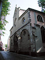
St. Maria Lyskirchen

detail

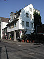
House of the Overstolzen (1230)
"Vromoltshaus", an arcade house


Another relic of the past is the "Vromoltshaus", first mentioned in 1312, which was considerably damaged in the Second World War . The " Overstolzenhaus ", a Romanesque patrician house built in 1230, located between Rheingasse and Filzengraben, now houses parts of the Art Academy for Media after its restoration and is an outstanding attraction in the district around Filzengraben. After the restoration , they now illustrate the residential types of wealthy Cologne residents in the city that were common in the Middle Ages.
Coming from its last station, the street at the Malzmühle, “de Baach” flows through the Filzengraben and flows into the Rhine.
Literature / sources
- Adam Wrede : New Cologne vocabulary. 3 volumes. 9th edition. Greven Verlag, Cologne 1984, ISBN 3-7743-0156-5 .
- Manfred Groten (Ed.): Hermann Weinsberg (1518-1597). Cologne citizen and councilor. Studies of life and work. SH-Verlag, Cologne 2005, ISBN 3-89498-152-0 .
- The Chronicle of Cologne. Chronik Verlag, Dortmund 1991, ISBN 3-611-00193-7 .
Individual evidence
- ↑ cf. A. Wrede: The Sülz monastery near Cologne. Map insert, 1909.
- ↑ The Chronicle of Cologne. 1991, p. 121.
- ↑ Handwritten writing 1591. - HASTK, Chron. U. Darst 51 BI.221 v. - Print: Weinderg 3, p. 121.
- ↑ about Weinsberg and Malzmühle (link revived in January 2016)