Burbacher Bach
| Burbacher Bach | ||
|
Stream course |
||
| Data | ||
| Water code | DE : 27373222 | |
| location | North Rhine-Westphalia ; Germany | |
| River system | Rhine | |
| Drain over | Rhine → North Sea | |
| source | in Alstädten-Burbach earlier in the west of Berrenrath 50 ° 52 ′ 31 ″ N , 6 ° 50 ′ 43 ″ E |
|
| muzzle |
Cologne Rand Canal coordinates: 50 ° 53 ′ 44 ″ N , 6 ° 52 ′ 25 ″ E 50 ° 53 ′ 44 ″ N , 6 ° 52 ′ 25 ″ E
|
|
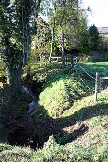
The Burbacher Bach (also called Bornbach or Burbach for short) is a brook in Hürth in the foothills west of Cologne . It is the Oblerlauf of the Stotzheimer Bach . Before lignite mining began , it originated in the west of the historic Berrenrath . Three mills were previously operated on the stream.
Today the Burbacher Bach rises from the Hürther Waldsee near the Burbach Monastery . It runs through Burbach and becomes the Stotzheimer Bach at the transition between Burbach and Stotzheim . This originally flowed into the Duffesbach , but nowadays on the western edge of Stotzheim into the Cologne Rand Canal . The course of the Burbacher Bach, which is still near-natural for long stretches, is classified as a protected biotope . Most of the Bachverlaus is accessible as a parallel hiking trail.
Individual evidence
- ↑ Protected biotope according to § 62 Landscape Law NRW ( Memento of the original from March 5, 2016 in the Internet Archive ) Info: The archive link has been inserted automatically and has not yet been checked. Please check the original and archive link according to the instructions and then remove this notice.
- ↑ Stadtwerke Hürth

