Hürther Waldsee
|
Hürther Waldsee (Theresiasee) |
||
|---|---|---|

|
||
| Geographical location | North Rhine-Westphalia , Germany | |
| Location close to the shore | Huerth | |
| Data | ||
| Coordinates | 50 ° 52 '26 " N , 6 ° 50' 42" E | |
|
|
||
| Altitude above sea level | 88.6 m above sea level NN | |
| surface | 10.6 ha | |
| length | 680 m | |
| width | 260 m | |
| Maximum depth | 8 m | |
|
particularities |
Open pit residual lake , nature conservation lake |
|

|
||
| Map of the Villeseen | ||
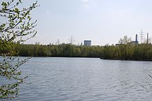
The Hürther Waldsee (also Theresiasee ) is a residual open pit lake from lignite mining in the southern part of the Rhenish lignite mining area in North Rhine-Westphalia south of Cologne in the area of the city of Hürth . It has an area of 10.6 hectares and a maximum depth of about 8 meters and is located in the recultivation area of the Theresia mine field, which was charred from 1965 to the beginning of the 1980s .
location
The Hürther Waldsee is located together with the Otto-Maigler-See at the northern end of the Ville-Seen-Platte, an approximately 50 km² large, extensive area with mixed forests and over 40 lakes south of the city of Cologne in the Rhein-Erft district . The area is part of the Rhineland Nature Park .
It is located in a wooded area between the southern district of Knapsack and northern Alstädten-Burbach, in the immediate vicinity of the former Cistercian convent Marienborn .
Emergence

Like all lakes in the Ville , the Hürther Waldsee came into being after the brown coal mining industry ended. The remaining hole was continuously filled with groundwater and thus formed today's lake in the immediate vicinity of the much larger Otto Maigler lake. The Hürther Waldsee was only created in 1988 and is one of the youngest lakes on the Ville-Seen-Platte.
The forest lake was planned and created with biotope structures. The larger body of water contains an underwater dam and two islands. Further subdivisions of the lake are shallow water zones and pools. Originally the shallow water area was planned in such a way that the water level could be lowered by half a meter during bird migration in order to create additional mud surfaces. Due to the good growth of the reeds, however, it was decided to keep the water level constant. This represents an additional support measure for animal species whose habitat is the reeds.
meaning

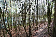
In contrast to the Otto-Maigler-See, the Hürther Waldsee is located in a nature reserve and can only be reached in a few places in the north by a forest path. Very early on after its creation, it was designated as a nature reserve with the aim of restoring the habitats of certain wild plant and animal species ; a few years later, several protected species were found in the area. It represents an important retreat for water birds near the Otto Maigler Lake, which is heavily used by tourists.
The surrounding forest is a young mixed forest with beech and alder populations, in which birch and other deciduous trees are scattered. In the environment can also be found some rare plants, including the orchids scoring Bee Orchid ( Ophrys apifera ).
The bat species "noctule bat", which is on the Red List of Endangered Species, has also been recorded at the Sophienhöhe (Hambach) and at the Hürther Waldsee. Freshwater snails and mussels, water bugs, water beetles, butterflies, as well as the endangered grasshopper species, the long-hop thorn insect and the blue-winged wasteland insect, have also been found in and around the forest lake .
Systematic fishing of the forest lake has been carried out since the 1990s for a long-term study by the State Institute for Ecology, Land Management and Forests in North Rhine-Westphalia on the natural succession of fish fauna in recultivation waters.
In the future, the Hürther Waldsee is to become an important nature conservation and FFH area according to European guidelines through a project of the RegioGrün initiative . The implementation of the FFH guidelines for the protection of nature is also provided for in the regional plan for the Cologne administrative district, sub-section Cologne region, of the Cologne district government: In the BSN "Hürther Waldsee westlich Hürth" (62028- 993) in the city of Hürth (Rhine-Erft -Kreis), the extremely valuable breeding and resting area of endangered water bird species is to be protected, preserved and basically left to natural development.
See also
- Brown coal in Hürth
- List of lakes in North Rhine-Westphalia
- List of nature reserves in the Rhein-Erft district
- Villeseen
literature
- Claus Albrecht, Ulf Dworschak, Thomas Esser, Horst Klein, Jochen Weglau: Animals and plants in recultivation. 40 years of field research in the Rhenish lignite mining area (= Acta biologica Benrodis. Supplement vol . 10). Verlag Natur & Wissenschaft, Solingen 2005, ISBN 3-936616-35-3 .
- Wolfram Pflug (Hrsg.): Brown coal mining and recultivation. Landscape ecology - reuse - nature conservation. Springer, Berlin et al. 1998, ISBN 3-540-60092-2 .
supporting documents
- ↑ a b c d e TU Cottbus: Lignite mining lakes in Germany - Current state of knowledge about water management issues of lignite opencast mining holes ( Memento of the original from September 2, 2011 in the Internet Archive ) Info: The archive link was inserted automatically and has not yet been checked. Please check the original and archive link according to the instructions and then remove this notice. (accessed on October 5, 2010; PDF; 14.0 MB)
- ^ Walter Buschmann , Norbert Gilson, Barbara Rinn: Brown coal mining in the Rhineland (= The architectural and art monuments of North Rhine-Westphalia 1: Rhineland ). Published by the Rhineland Regional Council and MBV-NRW . Wernersche Verlagsgesellschaft, Worms 2008, ISBN 978-3-88462-269-8 , p. 276 and 322.
- ↑ Kottenforst-Ville Nature Park (ed.): Brühl and the Ville Lakes. Leisure map 1: 25,000, 2008.
- ^ Plow: lignite mining and recultivation. 1998, p. 365, 409, ( Google Books ).
- ^ Plow: lignite mining and recultivation. 1998, pp. 409f., ( Google Books ).
- ^ Wilhelm von Dewitz: Orchids in the Hürth city area. In: Hürth contributions to history, culture and regional studies. Volume 87, 2008, ISSN 1864-5348 , pp. 103-115.
- ^ Albrecht et al.: Animals and plants in recultivation. 2005, p. 69.
- ^ Albrecht et al.: Animals and plants in recultivation. 2005, p. 213.
- ^ Albrecht et al.: Animals and plants in recultivation. 2005, p. 163.
- ^ Albrecht et al.: Animals and plants in recultivation. 2005, p. 137.
- ^ Albrecht et al.: Animals and plants in recultivation. 2005, p. 108.
- ^ Albrecht et al.: Animals and plants in recultivation. 2005, p. 174.
- ^ Albrecht et al.: Animals and plants in recultivation. 2005, pp. 92, 93.
- ↑ District government Cologne: Regional plan for the administrative district Cologne, section Cologne region. ( Text version ; PDF; 4.8 MB)


