
Otto Maigler Lake
| Otto Maigler Lake | ||
|---|---|---|

|
||
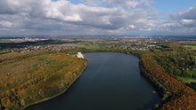
| Autumn, aerial view | ||
| Geographical location | North Rhine-Westphalia , Germany | |
| Location close to the shore | Huerth | |
| Data | ||
| Coordinates | 50 ° 52 '29 " N , 6 ° 49' 50" E | |
|
||
| Altitude above sea level | 88.7 m above sea level NN | |
| surface | 50.5 ha | |
| length | 2,220 m | |
| width | 395 m | |
| volume | 2.0 million m³ | |
| Maximum depth | 7 m | |
| Middle deep | 4.0 m | |
|
particularities |
Opencast mining lake , swimming lake , regatta lake |
|

|
||
| Map of the Villeseen | ||

The Otto-Maigler-See is a lake in the town of Huerth in the Rhein-Erft-Kreis , North Rhine-Westphalia . It was created after the lignite mining in a planned open pit .
location
The Otto-Maigler-See lies southwest of Cologne completely in the area of the city of Hürth in the recultivated southern part of the Rhenish lignite mining area in North Rhine-Westphalia, namely in the charred mine field Gotteshülfe . The lignite in Hürth and the associated economy have been known since early modern times. Today's local recreation area between Berrenrath, Gleuel, Alstädten-Burbach, Alt-Hürth and the Knapsack industrial area has been open to the public since June 1977. The nearby nature reserve, the smaller Hürther Waldsee , is for the most part not open to the public to compensate for this burden and is sealed off by fences or dense shrubs.
Emergence
The lake was created by inflowing groundwater after lignite mining in a planned open-cast mine . The recultivation operation plan of the then Rheinbraun, approved by the Brühl Mining Authority on October 3, 1959, was essentially based on preparatory work by the independent Cologne landscape architect Victor Calles , who had been doing this since 1946 for the recultivation of the mining areas in general and then in 1961 on behalf of the municipality to create a specific plan for the area of the field in the middle of the community. The area is now under landscape protection , under the jurisdiction of the Rhineland Nature Park . The remaining hole was originally divided by three clay ridges that were removed in order to join the individual areas into a large lake. At the same time, a sandy beach was created on the northwest side of the bank. The area of the Otto-Maigler-See is 30 m higher than the surrounding area. A three-row forest protection planting around the lake protects the agriculturally used surrounding area from the increased wind effect of the west and south-west winds (wind damage). The tree plantings also extend over the top edge of the slope. In addition, the edges of the dump were leveled and strengthened through forestry recultivation. They were designed with heels ( berms ) so that they can be used as paths and blend harmoniously into the environment.
Naming
On July 24, 1967, the Hürth municipal council decided, at the suggestion of the municipal director Otto Räcke , to name the regatta lake in the Otto-Maigler-See recreation area.
The name recalls the mining pioneer and director of Roddergrube AG Otto Maigler , who died shortly before on June 20, 1967 .
As a board member of Rheinbraun, Maigler had campaigned for the reforestation and recultivation of the district landscape. Furthermore, he played a key role in the planning for the relocation of the Berrenrath district . The district was rebuilt on the already charred area of the hamlet of Aldenrath in the immediate vicinity of the lake.
ecology
General
The RWE Power AG (formerly RWE Rheinbraun or Rheinbraun AG ) has been since the mid-1960s report in order to document the plant and animal wealth on reclaimed land of the brown coal mining area. These areas are also the subject of doctoral and diploma theses.
fauna
The lake is a migratory and winter quarters for various species of ducks, such as white-rimmed , tufted , mallard and pochard as well as a large number of mute swans . Occasionally there are also cormorants and golden ponds. The water birds find quiet breeding and retreat areas in the nearby Hürther Waldsee nature reserve .
The lake is also fishing water. The fishing club Burbach, founded in 1977, the year the lake opened, cherishes the lake and its fish stock in an umbrella organization called Otto Maigler See with fishing clubs in the surrounding towns and the Goldenberg factory. The lake is populated with eel , pike , carp , tench , pikeperch , perch and white fish . The club is troubled by the increasing number of cormorants fishing, especially in the quieter winter .
flora
The lake is embedded in a 142 hectare forest area with colorful trees. Laichkraut species, as well as the common horn leaf, have been identified on protected plants at Otto-Maigler-See.
sediment
As in almost all open pit lakes of the Ville-Platte, the bottom of the Otto-Maigler-See consists of clay and lignite residues covered by a sediment layer of deciduous and aquatic remains as well as detritus and digested sludge.
Hydrological data
The lake is located at the northern end of the Ville-Seen-Platte. It is long and narrow and is fed by groundwater and regulated by overflows. Due to the shallow depth, in contrast to deeper opencast mines, the water is circulated year-round by the action of wind.
Water quality
In 2008 the Stiftung Warentest classified the lake as a recommended bathing water. Because it is used as a bathing lake, it is forbidden to feed the birds on Lake Otto Maigler.
Because the lake is used for leisure and sports activities, the seaweed is trimmed and disposed of at regular intervals with a mower called a "manatee".
use

The Otto-Maigler-See is one of five approved bathing lakes in the Rhein-Erft district. During the bathing season it is checked by the health department through water tests for compliance with EU directives and the bathing water regulations. At the lake there is a lido with restaurants. Various events such as beach parties take place there in the summer evenings. Surfing, sailing and rowing are possible on the lake itself. It was designed in such a way that six regatta lanes fit side by side and so sports competitions can be held.
A number of associations share the use of the lake. Some, like the fishing club, were founded immediately after the lake opened. The former Marienborn Hürth-Burbach monastery is available to the canoeists of the Hürth swimming club at club houses. A newly built boathouse above the east bank of the Hürther Rudergesellschaft founded in 1979, which regularly organizes international regattas on the lake, is also used for training purposes by the Cologne Rowing Society 1891 . The Hürth Windsurfing Club, founded in 1978, has its Surfarea in the eastern part of the lake. The associations are listed and linked on the website of the city of Hürth (leisure and tourism) according to categories.
With the exception of the Knapsack industrial area, the recreation area with its cycling and hiking trails is easy to reach from all of the surrounding districts. The people of Cologne reach the lake via Berrenrather Straße and the parallel cycle paths through the Cologne green belt . A circular hiking trail leads around the lake, which is signposted from Alt-Hürth. The lido has a large car park and can also be reached with the Hürth city bus.
Trivia
On June 15, 2018, DHL Paket employees set the Guinness world record for most people on a raft on Lake Otto Maigler .
See also
literature
- Claus Albrecht, Ulf Dworschak, Thomas Esser, Horst Klein, Jochen Weglau: Animals and plants in recultivation. 40 years of field research in the Rhenish lignite mining area (= Acta biologica Benrodis. Supplement vol . 10). Verlag Natur & Wissenschaft, Solingen 2005, ISBN 3-936616-35-3 .
- Fritz Bendler: Report on the development of the local recreation area around the Otto-Maigler-See in Hürth. In: Hürther Heimat. Vol. 80, 2001.
- Marlies Breuer-Trost: Landscape change in the southern lignite mining area in the course of open-cast mining and recultivation; Mixed agricultural and forestry recultivation under the aspect of the recreational landscape using the examples of Kippe Berrenrath and United Ville open-cast mine near Knapsack. In: Hürther Heimat. Vol. 31/32, 1973, pp. 4-69.
- Wolfram Pflug (Hrsg.): Brown coal mining and recultivation. Landscape ecology - reuse - nature conservation. Springer, Berlin et al. 1998, ISBN 3-540-60092-2 .
Web links
Individual evidence
- ↑ a b c d e f TU Cottbus: Lignite mining lakes in Germany - Current state of knowledge about water management issues of lignite opencast mining holes ( Memento of the original from September 2, 2011 in the Internet Archive ) Info: The archive link was automatically inserted and not yet checked. Please check the original and archive link according to the instructions and then remove this notice. (accessed on October 5, 2010; PDF; 14.0 MB)
- ↑ a b Hürth home. Vol. 45, 1981, p. 51.
- ^ Plow: lignite mining and recultivation. 1998, p. 406, ( Google Books ).
- ↑ Fritz Bendler: Report on the development of the local recreation area around the Otto-Maigler-See in Hürth. in: Hürther Heimat , vol. 80, 2001, p. 35ff.
- ↑ Hürth home. Vol. 45, 1981, p. 51ff.
- ^ Breuer-Trost: Landscape change in the southern brown coal area. 1973, p. 50.
- ↑ Who was Otto Maigler? - FAQ on www.otto-maigler-see.de ( Memento of the original from July 13, 2009 in the Internet Archive ) Info: The archive link was automatically inserted and not yet checked. Please check the original and archive link according to the instructions and then remove this notice.
- ↑ Hürth home. Vol. 16, 1967, p. 43.
- ^ Albrecht et al.: Animals and plants in recultivation. 2005, p. 7.
- ^ Plow: lignite mining and recultivation. 1998, p. 366ff., ( Google Books ).
- ↑ Fish stock according to the fishing club Burbach ( Memento of the original from August 18, 2010 in the Internet Archive ) Info: The archive link was automatically inserted and not yet checked. Please check the original and archive link according to the instructions and then remove this notice. .
- ↑ Hürth home. Vol. 45, 1981, p. 53.
- ^ Plow: lignite mining and recultivation. 1998, p. 365. ( Google Books ).
- ^ Plow: lignite mining and recultivation. 1998, p. 363, ( Google Books ).
- ^ Plow: lignite mining and recultivation. 1998, p. 360, ( Google Books ).
- ^ Stiftung Warentest: The cleanest bathing areas test.de, May 30, 2008.
- ^ Plow: lignite mining and recultivation. 1998; P. 367, ( Google Books ).
- ↑ Information on compliance with the bathing water regulations etc. on rhein-erft-kreis.de ( memento of the original from March 4, 2016 in the Internet Archive ) Info: The archive link was inserted automatically and has not yet been checked. Please check the original and archive link according to the instructions and then remove this notice. .
- ↑ koeln-magazin.info
- ↑ DHL staff break record by building raft that can hold almost 1000 people