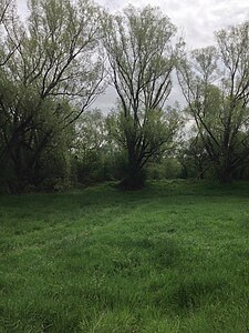
Witterschlick clay pit
|
Witterschlick clay pit
|
|
|
Nature reserve "Tongrube Witterschlick" |
|
| location | Alfter - Witterschlick , Rhein-Sieg-Kreis , NRW , Germany |
| surface | 12.9 ha |
| Identifier | SU-082 |
| WDPA ID | 319216 |
| Geographical location | 50 ° 41 ' N , 7 ° 1' E |
| Setup date | 1998 |
| administration | Lower landscape authority of the Rhein-Sieg district |
The Witterschlick clay pit is a nature reserve in the municipality of Alfter in the Rhein-Sieg district in North Rhine-Westphalia . The aim of the area is to preserve an abandoned clay pit as an important secondary habitat for numerous animal and plant communities.
location
The nature reserve is located in the Alfter district of Witterschlick . It is located west of the state road 113 and encloses a sports field. To the east is the Schenkenbusch mine , where clay is still mined today.
description
The property is a long-abandoned clay pit with relatively flat, completely bushy slopes on the sides facing away from the road. The dense sallow - birch - aspen - and willows and -Buschwäldchen the slopes close to the north of predominantly humid abandoned grasslands of. The pond, which is approx. 4000 m² in size, has a well-developed fringe of trees and bushes in the southern part, and the extensive silting area is also characteristic. The area between the pond and the sports field is taken up by willow bushes and smaller fallow grassland.
Web links
- Nature reserve "Tongrube Witterschlick" (SU-082) in the specialist information system of the State Office for Nature, Environment and Consumer Protection in North Rhine-Westphalia
- Regulatory authority ordinance on the nature reserve "Tongrube Witterschlick". District government Cologne, September 26, 2002 (PDF; 747 kB).
Individual evidence
- ↑ Schenkenbusch clay mine in Alfter-Witterschlick. Sibelco Deutschland GmbH, accessed February 15, 2018 .
- ↑ Schenkenbusch mine. Quiet on the clay mining front in Witterschlick. In: General-Anzeiger (Bonn). March 12, 2013, accessed May 3, 2015 .


