
Kessenich (Bonn)
|
Kessenich
Federal city of Bonn
Coordinates: 50 ° 42 ′ 45 ″ N , 7 ° 6 ′ 32 ″ E
|
|
|---|---|
| Height : | 67 m above sea level NHN |
| Residents : | 12,804 (Dec. 31, 2018) |
| Incorporation : | June 1, 1904 |
| Postal code : | 53129 |
| Area code : | 0228 |
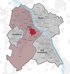  Location of the Kessenich district in the Bonn district
|
|
Kessenich is a district of the federal city of Bonn in the city district of the same name with around 12,500 inhabitants on an area of around two square kilometers.
geography
Geographical location
Kessenich is located in the south of Bonn on the bottom of the Cologne Bay formed by low terraces , which through the Godesberg Rhine valley funnel forms the transition from the Rhenish slate mountains to the Lower Rhine lowland bay . An Ice Age arm of the Rhine, the Gumme , dug into the lower terrace during the deepening of the Rhine valley in the Middle Quarter.
The border of today's district of Kessenich runs on the upper slope edge to Venusberg, the district of the same name in a westerly direction. The Gronau district borders on the Rhine side . To the north, the districts of Südstadt and Poppelsdorf join, and to the south, the district of Dottendorf .
The Kessenich district in the boundaries of the former municipality still exists today, it extends from the Venusberg plateau adjacent to the Röttgen district to the middle of the Rhine and partially includes the Gronau district.
geology
Apart from the gum , which was a marshland before the canalization of the streams running down the slope in the middle of the 19th century, the Kessenich valley floor consists largely of deep loess soil , one reason for the traces of settlement that were already evident at an early stage.
climate
Due to the location at the foot of the 40 square kilometer Kottenforst and the proximity of the Rhine stream as a fresh air corridor, the maximum temperatures in summer are lower and the air pollution is significantly lower than in the inner-city districts. The basin situation causes a humid climate in summer. In winter, inversion weather conditions with the typical fog banks are common along the Rhine.
The annual average temperature on the valley floor in Kessenich is 11 ° Celsius compared to 10 ° C on the Venusberg and peak values of 12.2 ° C for Bonn in the city center. The lowest average values of approx. 8 ° C are achieved on the Hardtberg .
history
Origin of name
The place name Kessenich appears in documents at the beginning of the 9th century as Keistenich, 843 as villa Castenicha, in copies Castenaca and Castenacha, later 1043 Kestenich, 1065 Chessinich, 1073 Chessenich, finally 1066 as Kessenich, then also as Kessinich and Kessenig. Today the origin of the name is traced back to the Gallo-Roman castiniacum, which points to a court of Castinus or Castinius. In the name of the Bonn Legion, the legate C. Julius Septimus Castinus appears at the beginning of the 3rd century, but it is not known whether this property was in Kessenich territory. An earlier derivation from the Celtic Cassanus "oak", which is used for the place of the same name Kessenich (Belgium) , has been discarded at the point mentioned. The district of the same name Kessenich (Euskirchen) could have the same origin, Castinus also placed a memorial stone near Iversheim in the sphere of influence of his legion.
Stone Age and Early History
Kessenich is an old settlement that already existed in pre-Roman times, and thus one of the oldest settlements in Bonn. The " Michelsberger Erdwerk" (dated to 4080 BC) on the Venusberg plateau, which is registered in the Bonn list of monuments as B 16, is for the most part within the Kessenich district. The year-round water-bearing Venusbergbach rises in the immediate vicinity with the deep loess soils on the lower terrace, creating a favorable location for early arable farmers.
Roman times
The Vicus Bonnensis , a civil Roman settlement with up to ten thousand people south of the Roman camp in Bonn, was largely within the boundaries of the Kessenich district . It is believed that wine has been grown in Kessenich since Roman times. A large number of the first finds of the vicus bonnensis are exhibited in the basement of the House of History . Further finds were made during the construction work on the WCCB .
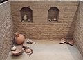
Cellar of a Roman house - place of discovery: House of History

Drunken Satyr - Location: House of History
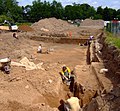
Archaeological excavations on the construction site of the WCCB (June 2006)


middle Ages

The provost of Kessenich, to which the Dottendorf crown estate belonged, was first mentioned in a document in 843. Emperor Lothar I , a grandson of Charlemagne, donated the fiefdom, which at that time consisted of eight men , to the Hessian count Esiko , who owned it in turn passed on to the Benedictine Abbey of Corvey . In 1449 Kessenich was the largest village in the Bonn office in the Electorate of Cologne.
In 1670 Kessenich comprised 118 houses.
The old St. Nicholas Church , which dates back to a hall building around 1050, is located above the new parish church in the old Kessenich cemetery and is the oldest surviving structure in Kessenich. The oldest known inscription of the place on a baptismal font with the date "Anno 1573" was found here.
Recent history

Catholic parish church of St. Nicholas

Haribo main plant on Hans-Riegel-Straße
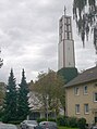
Evangelical Peace Church


In 1879 the " Bonner Eisclub eV " was founded, which in 1906 built its clubhouse on the Kessenicher Feld . In the years 1888–1890 the new parish church of St. Nicholas was built according to the plans of Johannes Richter .
In 1904, the previously independent was community Kessenich with an area of 578 hectares in the city of Bonn incorporated .
In 1920, Hans Riegel founded the Haribo company in Kessenich , which developed into one of the most important commercial enterprises in the city and characterized the district with several factory buildings and the distinctive smell of liquorice.
The Evangelical Peace Church was built in 1955 after Bonn had become the seat of government and the associated influx of government officials; In 1970 the peace parish was founded.
In the open-air museum Kommern there has been a half-timbered house from Kessenich since 1958, which was built in the 16th century, and since 2011 the interior of the ice cream parlor Dall'Asta, founded in 1967, which was abandoned by the operating family for reasons of age.
Monuments
The listed war memorial in Kessenich was erected in 1926 on behalf of the Kessenich Warrior Association .
Cultural-historical reception
literature
around 1820 - August Heinrich Hoffmann von Fallersleben (* 1798 in Fallersleben, † 1874 in Corvey)
„Ich hatte in Kessenich eine kleine Bauernwirthschaft entdeckt, wo man guten Wein und Butterbrot billig haben konnte“
The poet of the Deutschlandlied studied in Bonn from 1819 to 1821 and regularly walked to Kessenich, where he recorded some folk songs, among other things.
1853 - Johanna Kinkel (* 1810 in Bonn, † 1874 in London)
 In der Stadt Bonn um halber sieben,
              Da ist die Luft geschwellt
              Von Traubenblüt‘, soweit da reicht
              das Kessenicher Feld.
              (Johanna Kinkel, Bonn und London, im März 1853)
January 17, 1890 - Luigi Pirandello (* 1867 in Agrigento, † 1936 in Rome)
... We went down to Kessenich, which, as one can say, consists of a single long and wide street with simple low houses, almost all of them on the ground floor and of a very ancient construction. we were looking for a pub ... since the street was deserted and I couldn't see a pub sign either, perhaps attracted by the malicious smile, I decided to go to the young girl and asked her about it. She said that there was no need to look any further ... and as she crossed the spacious courtyard aroused the chatty flock of geese, who immediately gathered and followed her in great numbers, necks stretched, hopping on short feet and flapping their wings.
Travel description
1888 - Middle Rhine travel guide
… A pleasant, approx. 25 min. Longer path goes from the foot of the ruins of Godesberg via the villages of Friesdorf past the “Amalienhöhe” and an Alaunwerke, via Dottendorf with the Dottendorfer Höhe (view) and Kessenich to Bonn. Behind Kessenich you climb up a beautiful road to Rosenburg and Casselsruhe (restoration), where a wonderful panorama of the Rhine valley and the seven mountains opens up. Pretty paths lead over the Venusberg ridge to Poppelsdorf; from the castle on the right in 10 minutes to Bonn.
music
Around 1953 Christian Gratzfeld composed and wrote the five-stanza Kessenicher Heimatlied.
Others
Since 2004, the Kessenich ist Kult initiative has supported not only the establishment of a trade association, but also cultural and sporting activities and, last but not least, a “Kessenich feeling” through various campaigns.
The Catholic public library St. Nikolaus in Kessenich became Germany's first solar library in 2007.
Personalities
- Charles Amberg , librettist, songwriter and composer, born in Kessenich
- Josef Niesen , artist, author and publisher, lives in Kessenich
- Nikolaus water , a communist , was born in Kessenich and there in the resistance against Nazism have worked
Post-war settlements in the former "Wasserland"
Until the 1950s, Kessenich was clearly demarcated from the former government district bordering to the east by an almost undeveloped area called the Wasserland . The name was reminiscent of the time when the Rhine still had countless tributaries and consequently large areas on its banks were swampy. There was a farm there until the 1970s, a shepherd drove his herd from Löschkestrasse into the then undeveloped meadows of the Rheinaue and back again, and the site was largely unsuitable for further development. As a result of the housing shortage after the Second World War, this area was poorly drained and the settlement companies GAGFAH and AWOG began to build large-scale federal apartments and small terraced houses there from 1953. A rubbish dump including a small “groundwater lake” was filled in, and now there are spacious football, tennis and hockey pitches at this point ( Sportpark Wasserland ). The original naming of this residential area can still be read on the streets today: these mostly bear the names of neighboring Rhine tributaries ( Naheweg , Saarweg , Siegweg , Erftweg etc.). In an easterly direction, the Wasserland joined the Rheinauen via the Johanniter district (now Gronau ) and then turned into a huge green area that stretched as far as Plittersdorf in the south.
See also
- List of architectural monuments in the Kessenich district of Bonn
- List of streets in the Kessenich district of Bonn
- List of natural monuments in Kessenich
literature
- Dieter Partzsch: Do you know Kessenich? Verlag Divossen, Bonn 1999, ISBN 3-931543-58-7 .
- Josef Niesen , Bonn monuments and their builders, Edition Lempertz, Königswinter 2013, therein: detailed article on the Kessenich war memorial.
Web links
Individual evidence
- ↑ Population in Bonn by districts (according to the main statute) on December 31 , 2018 , Federal City of Bonn - Statistics Office, February 2019
- ↑ Statistics on Kessenich ( Memento from February 1, 2010 in the Internet Archive )
- ↑ State Survey Office North Rhine-Westphalia: Directory of the landmarks ( Memento from April 17, 2012 in the Internet Archive ) (as of 2005; PDF; 243 kB)
- ^ [1] Report from General Anzeiger Bonn, June 3, 2013
- ↑ [2] Weather photography geohabel
- ^ Karsten Brandt: Rheinische Luft. Bonn 2010 162 ff.
- ^ Max Perlbach, New Archive
- ↑ http://www.digizeitschriften.de/
- ^ Heinrich Tiefenbach: On the philology of the early Corveyer place-name tradition ( Memento from September 8, 2014 in the Internet Archive ).
- ^ Bursch: settlement names of the city of Bonn. 1987
- ↑ www.rheinische-geschichte.lvr.de - year 208 AD. ( Memento of the original from December 1, 2014 in the Internet Archive ) Info: The archive link was inserted automatically and has not yet been checked. Please check the original and archive link according to the instructions and then remove this notice.
- ^ Bonn: Contributions to its history and its monuments - 1868
- ↑ D. Partzsch · Hike through Bonn-Kessenich · Introduction (1997)
- ↑ [3] newspaper article
- ↑ [4] (PDF; 1.7 MB) see 41
- ↑ Archived copy ( Memento of the original dated August 12, 2011 in the Internet Archive ) Info: The archive link has been inserted automatically and has not yet been checked. Please check the original and archive link according to the instructions and then remove this notice. Link to the Bach Development Plan of the City of Bonn
- ↑ D. Partzsch, p. 8 ff. (Historical overview)
- ^ [5] The imperial documents of the province of Westphalia 777-1313. . . , Volume 1, Franz Friedrich Roger Wilmans , Friedrich Philippi - January 1, 1867, Regensberg-Verlag
- ^ LVR-Freilichtmuseum Kommern, Museum Guide (2009), p. 146.
- ^ A b Wilhelm Fabricius : Explanations of the historical atlas of the Rhine Province, Volume 2: The map of 1789. Bonn 1898, p. 58.
- ↑ [6] Verification on www.inschriften.net
- ↑ http://www.friedenskirche-bonn.de/gemeinde/geschichte.php
- ↑ Archived copy ( memento of the original from August 8, 2014 in the Internet Archive ) Info: The archive link was inserted automatically and has not yet been checked. Please check the original and archive link according to the instructions and then remove this notice. Website of the LVR open-air museum in Kommern.
- ↑ Archived copy ( memento of the original from March 7, 2016 in the Internet Archive ) Info: The archive link was inserted automatically and has not yet been checked. Please check the original and archive link according to the instructions and then remove this notice. Reference calendar sheet
- ↑ Hoffmann von Fallersleben: My life. Two parts, part 1, Berlin 1894, p. 139.
- ↑ In print in: Monthly magazine for the history of West Germany […] 4 (1878), pp. 285–289
- ↑ Pirandello, Luigi and Willi [eds.] Hirdt - Bonn in the work of Luigi Pirandello. German / Ital 1990 ISBN 3-8233-4105-7
- ↑ Middle Rhine, Moselle, Lahn, Eifel, Taunus and Westerwald - Baumgarten, Johannes - 4th edition, Coblenz: Groos, [1888]
- ↑ Josef Niesen , Bonn im Spiegel der Musik, in: Bonner Geschichtsblätter, Volume 64, Bonn 2014.
- ↑ http://www.kessenich-ist-kult.de/
- ↑ KÖB St. Nikolaus - Germany's first solar library ( Memento of the original from June 21, 2017 in the Internet Archive ) Info: The archive link was automatically inserted and not yet checked. Please check the original and archive link according to the instructions and then remove this notice.
- ↑ A dead arm of the Rhine even reached today's Weidengarten behind Hausdorffstrasse and the street was therefore originally called In der Gumme (D. Partzsch, p. 76).
- ↑ D. Partzsch, pp. 80–91
- ↑ Site plan of the water country ( Memento of the original dated December 2, 2011 in the Internet Archive ) Info: The archive link was inserted automatically and has not yet been checked. Please check the original and archive link according to the instructions and then remove this notice. Retrieved November 27, 2009

![[2]](http://www.geohabel.de/bilder/herbst/20050920/panorama20050920_1.jpg)
City districts: Bad Godesberg | Bulge | Bonn | Hardtberg
Districts: Alt-Godesberg | Auerberg | Beuel center | Beuel-Ost | Bonn-Castell | Bonn Center | Brüser Berg | Buschdorf | Dottendorf | Dransdorf | Duisdorf | Endeich | Friesdorf | Geislar | Godesberg-North | Godesberg villa district | Graurheindorf | Gronau | Hard height | Heiderhof | Hochkreuz | Wood | Holtorf | Holzlar | Ippendorf | Kessenich | Küdinghoven | Lannesdorf | Lengsdorf | Lessenich / Meßdorf | Limperic | Flour | Muffendorf | Nordstadt | Oberkassel | Pennenfeld | Plittersdorf | Poppelsdorf | Pützchen / Bechlinghoven | Ramersdorf | Röttgen | Rüngsdorf | Schwarzrheindorf / Vilich-Rheindorf | Schweinheim | Südstadt | Fir bush | Ückesdorf | Venusberg | Vilich | Vilich-Müldorf | West town