
Weststadt (Bonn)
|
West town
Federal city of Bonn
Coordinates: 50 ° 44 ′ 0 ″ N , 7 ° 5 ′ 13 ″ E
|
|
|---|---|
| Height : | 59 m above sea level NHN |
| Residents : | 7896 (Dec. 31, 2018) |
| Postcodes : | 53115, 53121 |
| Area code : | 0228 |
  Location of the Weststadt district in the Bonn district
|
|
The West City is a district of the federal city of Bonn in the same district with about 7,800 inhabitants. It is located southwest of the center in front of the districts Endeich and Poppelsdorf and between Nordstadt and Südstadt . The Weststadt is characterized by the Wilhelminian style residential district on the one hand and a large commercial area on the other.
The district corresponds roughly to the statistical districts Baumschulviertel and Bonn-Güterbahnhof . The former district building of the former district of Bonn is located in the western part of the city .
geography
The western part of the city is separated from the inner and northern part of the city by the rails of the left Rhine route . To the east, it borders the Südstadt on Poppelsdorfer Allee . To the south, the development merges directly into the Poppelsdorfs, to the west the 565 federal motorway forms the border with Endenich. The eastern residential area of the Weststadt is also called the musicians' quarter , as the streets there are mostly named after composers, or referred to as the tree nursery based on the former electoral tree nursery . The north-western third of the district is the Güterbahnhof industrial estate .
Infrastructure
The most important traffic artery of the Weststadt is the old one. It separates residential and commercial areas. From the Viktoriabrücke over the railway line it leads in the direction of Endenich, where there is a motorway junction at the Junction , known as the Endeicher Ei . In addition to Poppelsdorfer Allee, the street network of the Weststadt is determined by other large avenues, the Meckenheimer Allee, Endeicher Allee and Baumschulallee. Bonn Central Station is to the northeast of Weststadt . Formerly the Bonn freight station was located in the western part of the city, from here the Wesselbahn passed through today's industrial area.
There are among other things the incinerator Bonn, a natural gas - power plant , the master branch of Knauber and some other retail markets. Areas of the old Bonn slaughterhouse and a converted bus hall of the SWB are also used .
Attractions
The Weststadt and the Südstadt form one of the largest Wilhelminian-style districts in Germany. The larger representative buildings include the building of the Rhineland Chamber of Agriculture on Endenicher Allee and the Borromäushaus on Wittelsbacherring. The Malteser Hospital, which was destroyed at the end of the Second World War, was at the eastern end of Malteserstrasse. In the center of the musicians' quarter is the tree nursery forest , an urban park. This is the war memorial commemorating the the First World War fallen soldiers of the Infantry Regiment. 160 . The memorial was created by sculptor Peter Terkatz and inaugurated on May 21, 1939. The Kurfürstliche Gärtnerhaus is located on the edge of the park, facing Beethovenplatz . The gardener's house was renovated in the 1960s and has been showing art exhibitions ever since. Some of them are thematic, for example "Water Moves" others are retrospective, such as the exhibition on the 80th birthday of Alf Bayrle in 1980. The Rheinisches Landesmuseum Bonn is a museum in the Weststadt , which presents the art and cultural history of the Rhineland since the early days .
education
With parts of the mathematical institutes in the former Rhineland Chamber of Agriculture and in Wegelerstraße, Weststadt has a share in the Poppelsdorf campus of the Rheinische Friedrich-Wilhelms-Universität Bonn . In addition, the Ernst-Moritz-Arndt-Gymnasium , one of the ten municipal high schools , is located on Endeicher Allee .
Views of the west city

Wilhelminian style houses

Rheinisches Landesmuseum Bonn

Former building of the Rhineland Chamber of Agriculture, now the Mathematical Institute of the University of Bonn
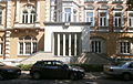
Former district building, Mozartstrasse 4–10 (2014)

Electoral gardener's house


.jpg)

See also
Web links
Individual evidence
- ↑ Population in Bonn by districts (according to the main statute) on December 31 , 2018 , Federal City of Bonn - Statistics Office, February 2019

City districts: Bad Godesberg | Bulge | Bonn | Hardtberg
Districts: Alt-Godesberg | Auerberg | Beuel center | Beuel-Ost | Bonn-Castell | Bonn Center | Brüser Berg | Buschdorf | Dottendorf | Dransdorf | Duisdorf | Endeich | Friesdorf | Geislar | Godesberg-North | Godesberg villa district | Graurheindorf | Gronau | Hard height | Heiderhof | Hochkreuz | Wood | Holtorf | Holzlar | Ippendorf | Kessenich | Küdinghoven | Lannesdorf | Lengsdorf | Lessenich / Meßdorf | Limperic | Flour | Muffendorf | Nordstadt | Oberkassel | Pennenfeld | Plittersdorf | Poppelsdorf | Pützchen / Bechlinghoven | Ramersdorf | Röttgen | Rüngsdorf | Schwarzrheindorf / Vilich-Rheindorf | Schweinheim | Südstadt | Fir bush | Ückesdorf | Venusberg | Vilich | Vilich-Müldorf | West town