
Vicus bonnensis
The vicus bonnensis was the civil Roman settlement (lat. Vicus ) in the area of today's Bonn district of Gronau , which arose south of the legionary camp (lat. Castra Bonnensia ) and the surrounding camp village (lat. Canabae legionis ). Its heyday extended from the 2nd to the 3rd century AD. According to the current state of research, the settlement was built by the Romans at the same time as the castra Bonnensia . Estimates assume that up to 10,000 people lived in Bonn during this time. The core of the settlement was in the area west of the Federal Palace .
history
Excavations in the area of the vicus
Since 1850, numerous small, scattered reports of finds from private individuals or construction companies have been recorded and examined. The archaeologists were previously only from village-like settlements. The first larger finds that indicated a concentrated settlement were made e.g. B. during the construction of the House of History on Adenauerallee in 1989. Here, among other things, parts of the cellar of a residential building were exposed, which can now be viewed in the museum's basement. However, a lot was destroyed unnoticed by various building measures, especially in the post-war period. This was not willful, but had to do particularly with the difficulty of spotting signs and identifying finds during construction.
From May 2 to October 31, 2006, the largest continuous excavation that has been carried out in a Roman vicus in Germany took place in the center of the vicus on today's Dahlmannstrasse . The excavations had to be completed in October because a new congress center and hotel are being built at this point . The costs for the excavation and the archaeological investigation of the area were borne by the investor, the "SMI Hyundai Corporation". The static finds, with the exception of a few that can be recovered, will be destroyed during the construction work for the congress center. After completion of the by almost 50 specialists of the Rhenish Office for Heritage Management in Rhineland Regional Council carried out (LVR) Excavation six-month investigation took place the collected findings and data.
location

The vicus and its location became known in the first half of the 19th century and since then have been legally protected as a “permanent ground monument ”.
In Roman times, the Bonn vicus was located on a slightly elevated plateau on the Roman Rhine Valley Road . The settlement was on a steep slope not far from the Rhine , but not directly on the river. In Roman times, the elevated position offered an open view of the Rhine. A large public square stretched out in the center. In the north, the vicus was bounded by a natural cut in the terrain that sloped down towards the Rhine. It is said to have served as access to the river and probably led to a port. After the Second World War , the trench was completely leveled to develop the site as building land. The road leads to the west at right angles to the main traffic axis of the region in Roman times - today's federal road 9 / Adenauerallee - which led centrally through the vicus .
Overall, the settlement extended over an area of approx. 80 hectares . The 2006 excavation site to the west and east of Dahlmannstrasse only covers an area of 3.7 hectares. Large parts of the settlement have been destroyed by construction work in the past few decades. Reports by private individuals and construction companies about finds in the vicus area have been relatively rare since 1850. The actual dimensions of the settlement were not known to the archaeologists until the beginning of the excavations. Jürgen Kunow , the head of the Rhenish Office for Ground Monument Preservation , said, while he presented the finds in August 2006, as follows: “We found far more than we had expected. The life of Roman citizens on the Rhine has never presented itself to us like this. "
Design of the vicus

The Bonn vicus developed primarily along the main traffic axis (Rheintalstraße), which led along the Rhine from Cologne via the legion camp in Bonn to Koblenz . In the Bonn area it runs roughly identical to today's B 9. The vicus was formed at the height of today's Adenauerallee . Covered pedestrian paths (lat. Portico ) ran on both sides of the street , behind which so-called " strip houses " lay. These are long, narrow, gable half-timbered houses . The individual plots consisted of narrow, up to 300 m long plots, in the front areas of which the houses were. They were often used as shops, pubs or workshops. Behind it were the living rooms, which were joined by a long garden with garbage pits, wells, latrines or craft facilities (e.g. pottery ovens). The contents of the garbage pits are often indicative of the everyday life and occupations of the residents.
Numerous smaller streets and paths branched off from this main traffic axis. A large public square was found east of the street on the 3.7 hectare excavation site on Dahlmannstrasse, which probably served as a forum and formed the center of the settlement. The buildings listed below were located in the immediate vicinity of the square.
Core areas of the excavation on Dahlmannstrasse
monument

At the highest point of the site there was a probably multi-storey monument in Roman times, of which only the foundations of a rectangular niche (possibly an apse ) were found, the front and back of which were lined with imposing, but no longer preserved rows of pillars. The opening of the apse, in which one or more statues were probably located, points towards the Rhine. The pillar foundations on the Rhine side may have formed the basis for a columned hall (lat. Porticus ).
The size of the pillar foundations and the narrow spaces they form are unusual. It is believed that the monumental structure was intended to serve as a symbolic demonstration of Roman power for the Germanic tribes that lived on the opposite bank. However, the exact function of the building is still unknown.
The original length of the monument is not known as it was destroyed on both sides by modern construction measures.
Brick kiln

In the north-west of the monument are the remains of a late 1st or early 2nd century brick kiln , which had already been shut down in Roman times and partially leveled to make way for the large open space behind the monument and stretched south of the temple.
The brick kiln consists of a wide central section from which right-angled side sections extend. These distributed the heating gases over the entire surface of the furnace. The gases got through a perforated clay floor (a so-called perforated antenna ), on which the firing material was stacked, in the upper part, which was covered by a dome. In the rear part of the system there is a working pit from which the furnace was operated. A rectangular shaft was found on the opposite side of the furnace, the meaning of which is so far unknown.
The brick kiln was used to manufacture various types of building ceramics (e.g. roof tiles or masonry tiles). Unburned bricks were found near the furnace . The furnace was built very early and used the raw material from the clay pits in the west of the excavation area until they were converted into waste pits. Trapped sediments indicate that the furnace has been shut down in the meantime. It was later restored and operated until it had to give way to the public square of the settlement.
Gallo-Roman common temple

Immediately to the west of the brick kiln is a small Gallo-Roman temple . Only parts of the excavation trenches of the foundations remain, which stand out as dark stripes from the surrounding soil. Originally the temple had a square footprint of approx. 10 m × 10 m. However, the northern part has been destroyed by a modern construction project. In the center of the temple was a small tower-like cella in which an image of a god stood. The cella was surrounded by a single row of columns supported by a pent roof . In addition, the temple was surrounded by a wall at a short distance that delimited the sacred area.
It is unclear which god was worshiped in this temple. Due to the shape, it has so far been at least excluded that it was the Roman god Iuppiter . It is also believed that the stones of the temple were used as building material for other buildings in the Middle Ages. Therefore only the excavated trenches and only small parts of the foundations that have crumbled away remained.
Grave finds
The short slope leading down from the temple to the bathing building indicates a path that was used by visitors to the temple. This assumption is supported by the discovery of three adjacent tuff box graves and a brick plate grave as well as the location of numerous metal finds in the eastern slope area. The grave goods also included a small bronze statuette of a genius from the late 1st century and coins mainly from the 1st to 3rd centuries AD.
Roman bath building

In the north of the excavation area there was a 200 m² public Roman bath . The size of the bath suggests that it served the public and was not used privately. The hot bath and the leaf bath (Latin: caldarium and tepidarium , each 6 × 5 meters) are clearly identifiable. It is assumed that the slightly raised room in the south-east of the bath represented the cold bath (lat. Frigidarium ). Only a small part of the basin has survived. The rest of the system was identified as the heatable substructure due to its lower location and the heavily sooty floors and walls. This underfloor and wall heating ( hypocaust system ) heated the rooms of the hot and leaf bath from the praefurnia . The heat penetrated up through hollow bricks on the walls. The water itself was heated outside in water tanks and fed into the basin via lead pipes.
There are also traces of the columns that were erected at regular intervals and that supported the floor of the bathroom. Over the course of time, the floor has collapsed in large slabs. The archaeologists were able to uncover contiguous remains of the wall with a height of up to 1.5 meters and a thickness of up to one meter. It is the third completely preserved thermal bath in North Rhine-Westphalia at the time of the excavations .
Preservation of the bathing building
Since the new hotel was built on the site of the bathing facility, the bathing building would have been completely destroyed by the new foundations. Therefore, the implementation of the Roman remains was sought. The facility, which weighs around 30 tons, is now integrated into a luxurious fitness and wellness center in the basement of the new hotel. In future, it will also be open to the public through a glass ceiling.
With the help of a diamond rope, the bathroom building was now sawn into five parts and lifted with the help of a lattice boom crane.
The relocation and subsequent reconstruction will cost around 1.5 million euros. The state of North Rhine-Westphalia contributed 250,000 euros, the Rhineland Regional Council 100,000 euros and the city of Bonn contributed 400,000 euros. The remaining costs will be covered by SMI Hyundai.
When lifting the warm water bath (lat. "Tepidarium"), however, a cavity under the remains was overlooked and led to a crack in the foundation. The foundations were secured and reinforced in good time and are now 56 meters further on their final location on a concrete slab.
Strip houses, canals and garbage pits

On the smaller area on the opposite side of Dahlmannstraße, the terrain sinks sharply and is also characterized by a cut in the terrain that was probably used as a road. This is supported by the find of eight strip houses approx. Seven meters wide, which were built here in a north-south direction. The strip houses along Adenauerallee have an east-west orientation. This indicates a diversion from the main traffic route that led through the vicus to the Rhine. The assumption that there was a small port on the banks of the Rhine has given archaeologists the name “Hafenviertel” to this residential area. In this part of the vicus bonnensis , indications of a potter and a glassblower were found on the basis of various finds in garbage pits . Numerous millstone fragments and a completely preserved millstone were also found along the road, which indicates a trader. The foundations carried a wooden framework construction. It is assumed that other strip houses made entirely of wood also existed in the settlement.

A wide canal to the Rhine ran parallel to the road. Two smaller, almost parallel canals from the south ran vertically into the broad canal. They are 40 m apart and at least 1.3 m below the Roman level, with a cross-section of only half a meter. Some of them could be exposed or proven over a length of 70 m. The canals consisted of dry laid greywackle slabs and had no floor. It is believed that they were clad with wooden planks to allow a minimum of water resistance.
On both sides of the western canal there is a large waste pit with a diameter of up to 50 m and a depth of almost 4 m. The pits were originally used to extract clay, which was then burned into building material in the brick kilns. The pits were used as waste pits for building land and then leveled. Here the archaeologists were able to recover large amounts of bones and ceramics, which are related to the activities of various craft trades such as B. butcher, glue boiler , blacksmiths and non-ferrous metal craftsmen. Trade relations with southern France during the first three centuries AD could also be proven on the basis of the discovery of tableware made from Terra Sigillata from Gaul.
Found objects
A large number of the first finds of the vicus bonnensis are exhibited in the basement of the House of History .
The following finds from the 2006 excavation are particularly noteworthy:
- A two-inch long hairpin made of bone material with a carved human head on top. The needle is a unique find in Germany.
- A plate made in La Graufesenque in southern France from Terra Sigillata, which was provided with the manufacturing stamp of the potter Vitalis. The plate, which was produced in the years 70–95 AD, indicates a supra-regional trade in.
- A fragment of a relief bowl made of Terra Sigillata from the 2nd or 3rd century AD. The vessel was made in Trier and represents an erotic scene.
- A fragment of a so-called " face urn " from the 2nd or 3rd century AD.
- An amphora disc with four tituli picti ( brush inscriptions ) applied after the fire to the empty and full weight of the amphora.
- A drinking cup from the 3rd century with a later unprofessionally incised Latin saying and decorations. The text reads "JOLLA VTERE F [elix]" (Eng. Use this vessel happily ... )
- A pendant made of bronze in the shape of an eagle from the 2nd to 3rd centuries.
- A bronze coin ( dupondius ) of the emperor Hadrian , which was minted in the years 128-138 AD. The front depicts the emperor's head with a crown of rays. On the back the goddess Hilaritas (goddess of happiness / serenity) can be seen with a palm branch and cornucopia. A child stands to the left and right of her.
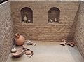
Cellar of a Roman house - place of discovery: House of History

Roman loom - place of discovery: House of History

Drunken Satyr - Location: House of History


Pre-Roman and modern finds
Individual settlement finds from the Iron Age and the Neolithic Age were also uncovered. However, they occur only in small quantities and indicate individual, incoherent farms on the elevated plateau on the Rhine.
In addition to these and the Roman finds, the archaeologists also found evidence from different ages: also modern objects, porcelain statues, helmets of the Wehrmacht and the US armed forces from the Second World War, a Coke bottle from the post-war period, a receiver from the former plenary hall and a DIN A4 - Large cardboard box with the inscription " Propaganda material of the CDU for the Bundestag election " from September 1957. These items will probably be handed over to the House of History .
Remarks
- ↑ List of monuments of the city of Bonn, numbers B 23 , B 24 and B 26
- ↑ FOCUS online (from August 17, 2006)
- ↑ Time. online ( Memento of the original from April 23, 2008 in the Internet Archive ) Info: The archive link was inserted automatically and has not yet been checked. Please check the original and archive link according to the instructions and then remove this notice. (from August 16, 2006)
- ↑ Grand Opening of the Marriott Hotel - The Marriott celebrates its opening . In: General-Anzeiger Bonn . April 10, 2016 ( general-anzeiger-bonn.de [accessed April 4, 2017]).
- ↑ Die Welt of March 28, 2007: Moving with Obstacles . By Joachim Budde
- ↑ General-Anzeiger of March 28, 2007: Mobilization for Roman property . By Bernd Leyendecker
See also
literature
- Jeanne-Nora Andrikopoulou-Strack: The Roman vicus of Bonn . In: Bonner Jahrbücher 196, 1997, pp. 421–468.
- Jeanne-Nora Andrikopoulou-Strack: The Roman vicus of Bonn . In: Manfred van Rey (ed.): History of the city of Bonn - Bonn from prehistory to the end of the Roman era , Bonn 2001, ISBN 3-922832-26-1 , pp. 199–221.
Web links
Coordinates: 50 ° 43 ′ 7.6 ″ N , 7 ° 7 ′ 21.5 ″ E