
Marckolsheim
| Marckolsheim | ||
|---|---|---|

|
|
|
| region | Grand Est | |
| Department | Bas-Rhin | |
| Arrondissement | Sélestat-Erstein | |
| Canton | Sélestat | |
| Community association | Ried de Marckolsheim | |
| Coordinates | 48 ° 10 ′ N , 7 ° 33 ′ E | |
| height | 170-184 m | |
| surface | 33.36 km 2 | |
| Residents | 4,151 (January 1, 2017) | |
| Population density | 124 inhabitants / km 2 | |
| Post Code | 67390 | |
| INSEE code | 67281 | |
| Website | www.marckolsheim.fr | |
 Marckolsheim, Hôtel de Ville (town hall) |
||

Marckolsheim (German: Markolsheim , in dialect "Markelse") is a French commune with 4151 inhabitants (as of January 1, 2017) in the Bas-Rhin department in the Grand Est region (until 2015 Alsace ). It belongs to the canton of Sélestat in the Arrondissement of Sélestat-Erstein and is a member and seat of the Ried de Marckolsheim community association founded in 2012 .

geography
Marckolsheim is in the south of the Grand Ried landscape . The distance to the east of the Rhine , which forms the border with Germany , is six kilometers, to Colmar in the southwest it is 22 km, to Strasbourg in the north 50 km. Marckolsheim is the southernmost municipality in the Bas-Rhin department. The Rhine-Rhône Canal runs along its western edge .
Neighboring communities of Marckolsheim are Mackenheim in the north. Sasbach am Kaiserstuhl (Germany) in the east, Artzenheim in the south, Jebsheim and Grussenheim in the south-west, Elsenheim in the west and Ohnenheim in the north-west.
history
The history of Marckolsheim is closely linked to the history of Alsace . The place was mentioned for the first time in 960 in an inventory of the Lorsch Monastery . 1299 the place received from the Roman-German King Albert I , the city charter granted. During the 14th century the city was fortified. These facilities were partly destroyed again during the Thirty Years War (1618–1648). During this time, the population suffered from devastation and pillage and largely fell into poverty. In the Peace of Westphalia , most of Alsace was given to France.
There was an economic boom in the 19th century. After the Franco-Prussian War of 1870/71, Marckolsheim became part of the German empire Alsace-Lorraine . Many residents moved to other areas of France. Those who stayed were able to look forward to the introduction of electricity and telephone as well as a rail connection. In 1918 this time came to an end with the German defeat in the First World War .
The Second World War severely affected the border town. The population was evacuated to Le Bugue in the Dordogne department in southwest France in September 1939 . In June 1940 the place was bombed by German fighter planes and 80% of it was destroyed. The Church of St. George also went up in flames. In October 1940 the population returned and was housed by the Germans in a barrack camp. After the war, the reconstruction of the place began. The church was rebuilt in 1961.
Marckolsheim also became known in 1974/75 through the struggle of the Baden-Alsatian citizens' groups against the establishment of a bleaching plant. The occupation of the planned building site at that time was one of the beginnings of the environmental movement .
| year | 1962 | 1968 | 1975 | 1982 | 1990 | 1999 | 2009 | 2013 |
| Residents | 2029 | 3328 | 2779 | 3124 | 3306 | 3616 | 4242 | 4177 |
| Source: INSEE | ||||||||
Attractions
Casemate de Marckolsheim Sud
The bunker in the east of the city is part of the Maginot Line , which was built between 1930 and 1940 and is now a museum. The Mémorial-Musée de la Ligne Maginot is located in the south of the city. The museum uses the preserved casemates 35/3 of the Maginot Line for its exhibition, which also includes tanks and artillery. ( Location )
- Pictures of exhibits

Tank M4 Sherman of the French army, the inscription commemorates the fighting at Hartmannswillerkopf in the First World War.
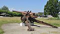
German 15 cm field howitzer 18

Gun turret
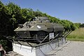
Reconnaissance tank M8 Greyhound of the French Army

Half-track vehicle M 16 of the French army


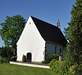
Saint-Grégoire Chapel
This chapel with restored frescoes from the 13th century leads a hidden existence. ( Location )
In the hamlet of Mauchen, in the south of Marckolsheim, there is the Chapelle Saint-Grégoire ("Chapel of St. Gregory"). In the 10th century it is said to have been a place of worship. The chapel was built in 1246, at the end of the Romanesque era, and is the only trace of the village of Mauchenheim , which was first mentioned in 777. At the time the chapel was built, a noble family from Mauchenheim settled here.
Between 1200 and 1300 the village of 200 to 250 souls disappeared as a result of looting, raids, flooding of the Rhine and plague epidemics. Above the entrance portal of the chapel you can see a restoration of the frescoes from the 13th century, which probably go back to the time of origin of the chapel and the von Mauchenheim family .
The chapel was destroyed during the Thirty Years War . The city of Marckolsheim paid for the restoration in the middle of the 18th century. A little later the small church became a place of worship until 1850. The Catholic parishes in the area undertook processions here on the feast days of St. Gregory and St. Mark. Abandoned again, the chapel served as a barn, cowshed and apartment. It was a place of refuge during the two world wars and was restored to its ritual purpose on August 15, 1970 after restoration.
From the outside you can see that the building has a contemporary east-west orientation. Two things can be clearly identified: The roof and the windows of the ship date from 1740, the year of renovation by the city of Marckolsheim. The small bell tower made of red sandstone dates from the 17th century, so it is older.
If you enter the chapel today, you will notice the lack of decoration. The 18th century frescoes, largely victims of World War II, testified that it wasn't always that way. The frescoes were divided into two parts: Above the entrance door, they represented part of the story of creation; the second part, probably from the end of the Middle Ages, depicts the 12 apostles. Only the former have been preserved thanks to preventive detention in 1907.
- Pictures of the chapel


Barrage
In the district of Marckolsheim there is a barrage of the Rhine canal with a lock , which is passed annually by around 20,000 ships, and the Marckolsheim hydropower plant of Électricité de France (EDF), which has existed since 1961 and generates more than 800 million kilowatt hours of electricity annually. There is also a border crossing to Germany over the Rhine bridge Sasbach-Marckolsheim to neighboring Sasbach am Kaiserstuhl .
Marckolsheim hydropower plant
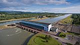
Marckolsheim hydropower plant

Marckolsheim lock

Marckolsheim barrage


Community partnerships
Marckolsheim entered into a partnership with the French municipality of Le Bugue in Aquitaine in 1988 in memory of the evacuation of part of the population at the beginning of the Second World War .
literature
- Le Patrimoine des Communes du Bas-Rhin . Flohic Editions, Volume 1, Charenton-le-Pont 1999, ISBN 2-84234-055-8 , pp. 602-610.
Web links
- Website of the Communauté de communes du Ried de Marckolsheim (CCME) (French)
- Le Grand Ried tourism website
- Occupation of the building site against a bleaching chemical plant in Marckolsheim in 1974/75