Up home
| Up home | ||
|---|---|---|

|
|
|
| region | Grand Est | |
| Department | Bas-Rhin | |
| Arrondissement | Sélestat-Erstein | |
| Canton | First stone | |
| Community association | Canton d'Erstein | |
| Coordinates | 48 ° 22 ′ N , 7 ° 41 ′ E | |
| height | 154-159 m | |
| surface | 7.99 km 2 | |
| Residents | 1,359 (January 1, 2017) | |
| Population density | 170 inhabitants / km 2 | |
| Post Code | 67230 | |
| INSEE code | 67338 | |
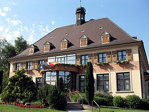
 Town hall Obenheim |
||
Obenheim is a French commune with 1,359 inhabitants (as of January 1, 2017) in the canton of Erstein in the Bas-Rhin department in the Grand Est region (until 2015 Alsace ).
geography
The place is located on the Rhine-Rhône Canal and is crossed by the department road D 468, which runs parallel to the Rhine . The community is located approximately at the level of the small town of Lahr on the right bank of the Rhine in the Black Forest . Seven kilometers southeast of Obenheim, in Rhinau , a car ferry runs across the Rhine to the German community of Kappel-Grafenhausen . The Alsatian metropolis of Strasbourg is a good 30 kilometers north.
history
From 1871 until the end of the First World War , Obenheim belonged to the German Empire as part of the realm of Alsace-Lorraine and was assigned to the Erstein district in the Lower Alsace district .
Population development
| 1910 | 1962 | 1968 | 1975 | 1982 | 1990 | 1999 | 2006 | 2017 |
|---|---|---|---|---|---|---|---|---|
| 892 | 901 | 1042 | 1127 | 1130 | 1078 | 1214 | 1352 | 1359 |
Attractions
The village center is rich in traditional half-timbered houses .
Churches
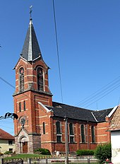
In addition to the Catholic Church, there is also a Protestant Church in Obenheim.
Sons and daughters of the church
- Frédéric-Henri Walther (1761–1813), general of the cavalry
literature
- Le Patrimoine des Communes du Bas-Rhin . Flohic Editions, Volume 1, Charenton-le-Pont 1999, ISBN 2-84234-055-8 , pp. 373-374.

