
Villé
| Villé | ||
|---|---|---|

|
|
|
| region | Grand Est | |
| Department | Bas-Rhin | |
| Arrondissement | Sélestat-Erstein | |
| Canton | Dirty | |
| Community association | Vallée de Villé | |
| Coordinates | 48 ° 21 ′ N , 7 ° 18 ′ E | |
| height | 253-470 m | |
| surface | 2.84 km 2 | |
| Residents | 1,834 (January 1, 2017) | |
| Population density | 646 inhabitants / km 2 | |
| Post Code | 67220 | |
| INSEE code | 67507 | |

Villé (German hamlet , Alsatian Willer ) is a French commune with 1,834 inhabitants (as of January 1, 2017) in the Bas-Rhin department in the Grand Est region (until 2015 Alsace ). It belongs to the Arrondissement Sélestat-Erstein and the Canton of Mutzig .
geography
Villé is located on Giessen in the Vosges , about 15 kilometers northwest of Sélestat . The valley of Giessen, which comes from the southwest and turns to the southeast, widens into a basin in the Villé area. The valley of the Ruisseau du Giessen de Steige opens to the northwest, the valley of the Erlenbach to the north and the Luttenbach valley to the south .
Neighboring communities of Villé are Albé in the northeast, Triembach-au-Val in the east, Neuve-Église in the southeast, Breitenau and Bassemberg in the southwest and Saint-Martin in the northwest.
Population development
| year | 1962 | 1968 | 1975 | 1982 | 1990 | 1999 | 2007 | 2017 |
| Residents | 1326 | 1422 | 1530 | 1616 | 1550 | 1743 | 1736 | 1834 |
Attractions
- Church of the Assumption ( Église Notre-Dame-de-l'Assomption )
- Protestant church
- Synagogue , built in 1904
- Church of the Assumption

tower 
inside view 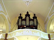
organ


Personalities
- Leo Vonderscheer (1864–1929), German member of the Reichstag, born in Villé.
- Joseph Meister (1876–1940) was a baker in Villé.
- Roger Siffer , Alsatian cabaret artist , songwriter and singer, was born in Villé in 1948.
literature
- Le Patrimoine des Communes du Bas-Rhin. Flohic Editions, Volume 2, Charenton-le-Pont 1999, ISBN 2-84234-055-8 , pp. 1521-1525.