
Reichsfeld
| Reichsfeld | ||
|---|---|---|

|
|
|
| region | Grand Est | |
| Department | Bas-Rhin | |
| Arrondissement | Sélestat-Erstein | |
| Canton | Obernai | |
| Community association | Pays de Barr | |
| Coordinates | 48 ° 22 ' N , 7 ° 23' E | |
| height | 285-660 m | |
| surface | 4.95 km 2 | |
| Residents | 296 (January 1, 2017) | |
| Population density | 60 inhabitants / km 2 | |
| Post Code | 67140 | |
| INSEE code | 67387 | |
| Website | http://www.reichsfeld.fr/ | |
 Mairie Reichsfeld |
||

Reichsfeld is a French commune with 296 inhabitants (as of January 1, 2017) in the Bas-Rhin department in the Grand Est region (until 2015 Alsace ). The village is on the eastern edge of the Vosges .
The coat of arms of the place, first mentioned in 1323 under the name Richtenzeveld , shows Saint Urban as patron saint with a book in his right hand and a bunch of grapes in his left, which suggests that viticulture in Reichsfeld has a long tradition.
From 1871 until the end of the First World War , Reichsfeld belonged to the German Empire as part of the realm of Alsace-Lorraine and was assigned to the Schlettstadt district in the Lower Alsace district .
Population development
| year | 1910 | 1962 | 1968 | 1975 | 1982 | 1990 | 1999 | 2008 | 2013 |
| Residents | 396 | 247 | 253 | 239 | 247 | 295 | 293 | 308 | 298 |
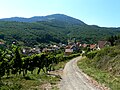
Place view
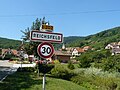
Entrance
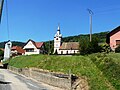
Saint-Urbain church

Saint-Urbain Church (interior view)


literature
- Le Patrimoine des Communes du Bas-Rhin . Flohic Editions, Volume 1, Charenton-le-Pont 1999, ISBN 2-84234-055-8 , p. 75.
See also
Web links
Commons : Reichsfeld - Collection of images, videos and audio files