Saasenheim
| Saasenheim | ||
|---|---|---|

|
|
|
| region | Grand Est | |
| Department | Bas-Rhin | |
| Arrondissement | Sélestat-Erstein | |
| Canton | Sélestat | |
| Community association | Ried de Marckolsheim | |
| Coordinates | 48 ° 14 ' N , 7 ° 37' E | |
| height | 164-170 m | |
| surface | 7.80 km 2 | |
| Residents | 600 (January 1, 2017) | |
| Population density | 77 inhabitants / km 2 | |
| Post Code | 67390 | |
| INSEE code | 67422 | |
| Website | http://www.saasenheim.fr | |
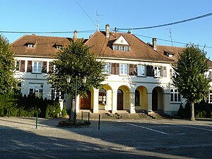
 Town hall and school in Saasenheim |
||
Saasenheim is a French commune with 600 inhabitants (as of January 1, 2017) in the Bas-Rhin department in the Grand Est region ( Alsace until 2015 ). The municipality in the Upper Rhine Plain belongs to the Arrondissement Sélestat-Erstein , the canton Sélestat and the Ried de Marckolsheim municipal association .
Neighboring communities of Saasenheim are Sundhouse in the north, Schœnau in the southeast and Richtolsheim in the southwest.
Population development
| year | 1962 | 1968 | 1975 | 1982 | 1990 | 1999 | 2007 | 2013 |
| Residents | 413 | 424 | 447 | 447 | 458 | 479 | 579 | 605 |
Community partnerships
Saasenheim has been linked with two municipalities in the Dordogne department since 1998 through municipal partnerships: Cazoulès and Salignac-Eyvigues , to which some of the residents were evacuated in 1939 at the beginning of the Second World War .
literature
- Le Patrimoine des Communes du Bas-Rhin . Flohic Editions, Volume 1, Charenton-le-Pont 1999, ISBN 2-84234-055-8 , pp. 619-620.
See also
Web links
Commons : Saasenheim - Collection of images, videos and audio files
