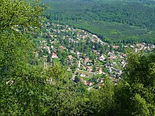
La Vancelle
| La Vancelle | ||
|---|---|---|

|
|
|
| region | Grand Est | |
| Department | Bas-Rhin | |
| Arrondissement | Sélestat-Erstein | |
| Canton | Sélestat | |
| Community association | Sélestat | |
| Coordinates | 48 ° 17 ' N , 7 ° 18' E | |
| height | 217-810 m | |
| surface | 7.88 km 2 | |
| Residents | 402 (January 1, 2017) | |
| Population density | 51 inhabitants / km 2 | |
| Post Code | 67730 | |
| INSEE code | 67505 | |
| Website | http://lavancelle.com/ | |
 Church of St. Ludwig, Monument historique |
||
La Vancelle (German: Wanzel , Alsatian: Wànzel ) is a French commune with 402 inhabitants (as of January 1, 2017) in the Bas-Rhin department in the Grand Est region (until 2015 Alsace ). The municipality is a member of the Communauté de communes de Sélestat .
geography
La Vancelle has the character of a scattered settlement and is connected by a side road with the Val de Villé and thus with the national road N59. The surrounding area in the Vosges is largely forested; to the north is the Forêt Domaniale de la Vancelle state forest . The place is dominated by the Altenberg massif with the Frankenburg castle ruins and the Rocher du Coucou (cuckoo rock) . La Vancelle is one of the border towns of the Alemannic dialect area .
Population development
| year | 1962 | 1968 | 1975 | 1982 | 1990 | 1999 | 2006 | 2017 |
| Residents | 203 | 213 | 240 | 244 | 294 | 373 | 388 | 402 |
literature
- Le Patrimoine des Communes du Bas-Rhin. Flohic Editions, Volume 2, Charenton-le-Pont 1999, ISBN 2-84234-055-8 , p. 1231.
Web links
Commons : La Vancelle - Collection of images, videos and audio files

