
Witternheim
| Witternheim | ||
|---|---|---|

|
|
|
| region | Grand Est | |
| Department | Bas-Rhin | |
| Arrondissement | Sélestat-Erstein | |
| Canton | First stone | |
| Community association | Canton d'Erstein | |
| Coordinates | 48 ° 19 ′ N , 7 ° 37 ′ E | |
| height | 159-163 m | |
| surface | 4.99 km 2 | |
| Residents | 507 (January 1, 2017) | |
| Population density | 102 inhabitants / km 2 | |
| Post Code | 67230 | |
| INSEE code | 67545 | |

Witternheim is a French commune with 507 inhabitants (as of January 1, 2017) in the Bas-Rhin department in the Grand Est region (until 2015 Alsace ).
history
The settlement already existed in the Bronze Age . Earlier place names were "Wilderceldenheim" in the 12th century and later "Witterheim". The noble families Rathsamhausen from Ehnwihr, a current district of Sessenheim , and Mueg from Boofzheim , were based in Witterheim .
From 1871 until the end of the First World War , Witternheim belonged to the German Empire as part of the realm of Alsace-Lorraine and was assigned to the Erstein district in the Lower Alsace district .
| 1910 | 1962 | 1968 | 1975 | 1982 | 1990 | 1999 | 2005 | 2010 | 2012 |
|---|---|---|---|---|---|---|---|---|---|
| 390 | 340 | 316 | 274 | 353 | 386 | 382 | 497 | 510 | 517 |

Saint-Sébastien church

Half-timbered houses
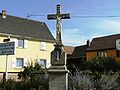
Wayside cross in place


literature
- Le Patrimoine des Communes du Bas-Rhin . Flohic Editions, Volume 1, Charenton-le-Pont 1999, ISBN 2-84234-055-8 , p. 111.
Web links
Commons : Witternheim - Collection of images, videos and audio files