
Meistratzheim
| Meistratzheim | ||
|---|---|---|

|
|
|
| region | Grand Est | |
| Department | Bas-Rhin | |
| Arrondissement | Sélestat-Erstein | |
| Canton | Obernai | |
| Community association | Pays de Sainte-Odile | |
| Coordinates | 48 ° 27 ' N , 7 ° 33' E | |
| height | 150-162 m | |
| surface | 12.82 km 2 | |
| Residents | 1,485 (January 1, 2017) | |
| Population density | 116 inhabitants / km 2 | |
| Post Code | 67210 | |
| INSEE code | 67286 | |
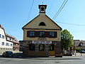
 Main street in Meistratzheim |
||

Meistratzheim is a French commune with 1,485 inhabitants (as of January 1, 2017) in the Bas-Rhin department in the Grand Est region (until 2015 Alsace ). The municipality is a member of the Communauté de communes du Pays de Sainte-Odile .
Until the French Revolution , the place was owned by the Landsberg family , who had acquired it from the diocese of Strasbourg .
Population development
| year | 1962 | 1968 | 1975 | 1982 | 1990 | 1999 | 2007 | 2017 |
| Residents | 1044 | 1072 | 1066 | 1265 | 1230 | 1302 | 1371 | 1485 |
Attractions
The Catholic Church of St. Andrew, built from 1911 to 1919, is 75 m tall and is the highest in Lower Alsace outside of Strasbourg . The old church of St. Andreas is now a cemetery chapel.
Meistratzheim town hall

St. Andrew's Church

typical half-timbered house


literature
- Le Patrimoine des Communes du Bas-Rhin. Flohic Editions, Volume 2, Charenton-le-Pont 1999, ISBN 2-84234-055-8 , pp. 914-916.
Web links
Commons : Meistratzheim - Collection of images, videos and audio files