Dordogne department
| Dordogne | |
|---|---|
| region | Nouvelle-Aquitaine |
| prefecture | Périgueux |
| Sub-prefecture (s) |
Bergerac Nontron Sarlat-la-Canéda |
| Residents | 413,606 (Jan 1, 2017) |
| Population density | 46 inhabitants per km² |
| surface | 9,060.16 km² |
| Arrondissements | 4th |
| Community associations | 22nd |
| Cantons | 25th |
| Communities | 505 |
|
President of the Department Council |
Germinal Peiro |
| ISO-3166-2 code | FR-24 |
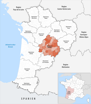
 Location of the department of Dordogne in the region Nouvelle-Aquitaine |
|
The Dordogne [ dɔʁdɔɲ ] is the French department of 24 with the ordinal number It is located in the southwest of the country, in the region Nouvelle-Aquitaine and is named after the river Dordogne named.
geography
The department is located in the east of the Nouvelle-Aquitaine region . It borders in the northwest on the Charente-Maritime and Charente departments , in the northeast on the Haute-Vienne and Corrèze departments , in the southeast on the Lot department of the Occitania region and within the region in the south on the Lot-et-Garonne department and in the southwest to the Gironde department .
The most important river is the eponymous Dordogne , which crosses the southern part of the department from east to west and flows through its second largest city, Bergerac . Coming from the northeast through the capital Périgueux and further west the Isle runs . As another right tributary of the Dordogne, the Vézère reaches the department in the east, then runs in a south-westerly direction and flows into the main river in Limeuil .
The north of the department is part of the Périgord-Limousin Regional Nature Park .
coat of arms
Three golden, blue-tongued and equally crowned (2: 1) standing lions in red .
history
The department was formed during the French Revolution on March 4, 1790 from most of the then existing province of Périgord . It was divided into nine districts (French: district), the forerunners of the arrondissements . The districts were Bergerac, Belvès, Excideuil, Montignac, Mussidan, Nontron, Périgueux, Ribérac and Sarlat. The department and the districts were divided into 72 cantons and in 1791 had 433,343 inhabitants. The capital was Périgueux , initially planned to alternate with Bergerac and Sarlat, but this was shelved in the same year.
The arrondissements were established on February 17, 1800. They were Bergerac , Nontron , Périgueux , Ribérac and Sarlat .
On September 10, 1926, the Arrondissement Ribérac was dissolved and integrated into the Arrondissement Périgueux.
When Sarlat and La Canéda were merged on March 1, 1965, the arrondissement was also renamed Sarlat-la-Canéda.
From 1960 to 2015 it belonged to the Aquitaine region , which in 2016 became part of the Nouvelle Aquitaine region.
Cities
The most populous municipalities in the Dordogne department are:
| city | Population (2017) |
Arrondissement |
|---|---|---|
| Périgueux | 29,966 | Périgueux |
| Bergerac | 26,833 | Bergerac |
| Boulazac | 10,635 | Périgueux |
| Sarlat-la-Canéda | 8,869 | Sarlat-la-Canéda |
| Coulounieix-Chamiers | 7,703 | Périgueux |
| Trélissac | 6,658 | Périgueux |
| Terrasson-Lavilledieu | 6,202 | Sarlat-la-Canéda |
| Saint-Astier | 5,492 | Périgueux |
| Montpon-Ménestérol | 5,498 | Périgueux |
Administrative division
The Dordogne department is divided into 4 arrondissements , 25 cantons and 505 communes :
| Arrondissement | Cantons | Communities | Residents January 1, 2017 |
Area km² |
Density of population / km² |
Code INSEE |
|---|---|---|---|---|---|---|
| Bergerac | 7th | 130 | 102,452 | 1,819.86 | 56 | 241 |
| Nontron | 4th | 94 | 54,425 | 2,097.70 | 26th | 242 |
| Périgueux | 14th | 143 | 175.216 | 2,869.33 | 61 | 243 |
| Sarlat-la-Canéda | 6th | 138 | 81,513 | 2,273.27 | 36 | 244 |
| Dordogne department | 25th | 505 | 413,606 | 9,060.16 | 46 | 24 |
See also:
- List of communes in the Dordogne department
- List of cantons in the Dordogne department
- List of associations of municipalities in the Dordogne department
Attractions
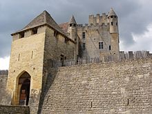
The Dordogne department is rich in archaeological sites ( Dolmen de Cantegrel , Dolmen Peyre Levade ) and caves as well as abrises with petroglyphs , rock paintings and sculptures from the Stone Age , troglodytic buildings and villages, and other natural caves that are open to visitors. Points of attraction are also some castles, numerous castles (see: List of castles and chateaux in the Dordogne ) and various abbeys.
Archaeological sites
- La Micoque , Laugerie-Haute and Laugerie-Basse , Abri de Cro-Magnon and Abri Pataud in Les Eyzies-de-Tayac-Sireuil
- Lascaux caves , Combarelles , Rouffignac , Font-de-Gaume in the Vézère valley
- Cap Blanc (Abri)
- Le Moustier (Le Ruth) at Payzac
- Le Régourdou in Montignac
- Castelmerle in Sergeac with
- La Ferrassie in Savignac-de-Miremont
Cathedrals
- St-Frond in Périgueux
- Cathedral of St-Sacerdos in Sarlat-la-Canéda
Former abbey or priory churches
- Cistercian Abbey of Cadouin
- Saint-Nicolas de Trémolat Abbey Church
- St-Martial de Paunat Abbey Church
- Priory Church of St-Léon (Saint-Léon-sur-Vézère)
Fortified churches
- St-Frond in Beaumont-du-Périgord
- St-Pierre in Audrix
- St-Amand-de-Coly
- Sanctuary of Notre-Dame de Temniac
Castles and Palaces
- Beynac Castle
- Castelnaud Castle
- Monbazillac Castle
- Montaigne Castle
- Biron Castle
- Hautefort Castle
- Les Milandes castle
Bastids
- Lalinde
- Villefranche-de-Lonchat
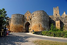
- Domme
- Belvès
- Beaumont-du-Périgord
- Monpazier
- Villefranche-du-Périgord
Web links
- Dordogne department (French)
- Prefecture of the Dordogne department (French)
Individual evidence
- ↑ https://www.dordogne.fr/connaitrele_conseil_general/l%E2%80%99assemblee_departementale/vos_elus/le_president/84 accessed on May 5, 2015
Coordinates: 45 ° 6 ' N , 0 ° 46' E


