
Nontron
| Nontron | ||
|---|---|---|
.svg)
|
|
|
| region | Nouvelle-Aquitaine | |
| Department | Dordogne | |
| Arrondissement | Nontron | |
| Canton | Périgord Vert Nontronnais (main town) | |
| Community association | Périgord Nontronnais | |
| Coordinates | 45 ° 32 ' N , 0 ° 40' E | |
| height | 152-308 m | |
| surface | 24.67 km 2 | |
| Residents | 3,050 (January 1, 2017) | |
| Population density | 124 inhabitants / km 2 | |
| Post Code | 24300 | |
| INSEE code | 24311 | |
| Website | http://www.nontron.fr/ | |
 City view Nontron |
||

Nontron , in Occitan Nontronh , is a town in the French region of Nouvelle-Aquitaine (before 2016 Aquitaine ) in the Dordogne department with 3050 inhabitants (as of January 1, 2017). The city is the seat of the sub-prefecture ( French Sous-préfecture ) of the Arrondissement of Nontron and the capital of the canton of Périgord Vert Nontronnais ( canton of Nontron until 2015 ). The responsible community association is the Communauté de communes du Périgord Nontronnais . The inhabitants are called Nontronnais or Nontronnaises .
etymology
The origin of the city name is somewhat diffuse. Allegedly the name development from Natadun via Nattun , Nantrun and Nontroun to the current Nontron should have run, whereby Natadun supposedly comes from Phoenician (Nata = valley, Dun = mountain).
Other possible explanations rely on Gallo-Roman proper names such as Nantirius , Nantironius or Nantirionius .
geography
Nontron is surrounded by the following seven neighboring communities:
| Saint-Martin-le-Pin | Le Bourdeix | Augignac |
.svg)
|
Savignac-de-Nontron | |
| Saint-Martial-de-Valette | Sceau-Saint-Angel | Saint-Pardoux-la-Rivière |
The municipality of Nontrons includes numerous scattered hamlets, secluded farms, mills, former brickworks and landmarks such as Azat , Balassou , Barouffières , Bois d'Azat , Bord , Brégout , Broillac , Chez le Maire , Chez Pouge , Chez Roderie , Fonladier , Fontaine de l'Age , Gaumondières , Goulat , Goulières , Gourbelières , La Bardinie , La Chapoulie , La Côte , La Francherie , La Maladrerie , La Mondinaude , La Mothe , La Paulinie , La Petite Tuilière , La Picaudie , La Roderie de Bord , La Serve Verte , La Truffière de Bord , La Tuilière , La Tuilière de Bord , Lacaud , Lafarge , Lamandeau , Le Center Aéré , Le Châtenet , Le Mas de la Roche , Le Meynissou , Le Moulin Blanc , Le Moulin du Bord , Le Pic , Le Puy , Le Puy de Fleury , Le Reclaud , Le Ruisseau de l'Étang , Le Vieux Manoir , Les Belles Places , Les Champs , Les Farges , Les Fourneaux , Les Granges , Les Justices , Les Loges , Les Mines du Puy , Les Nouailles , Les Petites Granges , Les Salles , Les Truffières , Moulin de Puissèché , Papelebre , Poperdu , Pré de Bellevue , Puymezier and Puyrigard .
The municipality of Nontron is located at an average sea level of 230 meters above sea level, its lowest point at 152 meters is on the Bandiat directly south of the city, its highest point at 308 meters north of the hamlet of Brégout in the east. The maximum height difference is 156 meters. The city center is located at 212 meters above sea level.
Transport links
.jpg)
Nontron is located off the main traffic axes, almost equidistant (around 50 kilometers) from Périgueux , Angoulême and Limoges . This geographical isolation has always prevented the city's economic boom.
Via the D 675 from Brantôme to Saint-Junien , the city has access to Périgueux on the one hand and the Haute-Vienne department on the other.
Furthermore, several department roads branch off from this north-south axis, such as the D 75 to Angoulême, the D 707 to Thiviers and the D 85 to Châlus and Limoges. There is a connection to Mareuil via the D 707 and to Villars via the D 3 . There are also some smaller connections to surrounding neighboring communities.
Between 1883 and 1940, Nontron was on the railway line Queroy-Pranzac-Thiviers connected to Angoulême, from 1892 with Thiviers. Freight traffic on this route in the direction of Thiviers was suspended from 1965 and in the direction of Angoulême from 1975.
The former station building is still there.
Hydrography

Nontron is built to the north high above a bend in the river of the Bandiat , which here begins to make a significant change of direction in its course from northeast-southwest to northwest. The river flows at a height of around 160 meters and has cut into the surrounding rocks up to 150 meters deep. The incision was made steeper on the northwest side than on the southeast side. The old town of Nontron towers over the river by a good 50 meters. When it reaches the municipal boundary of Nontron in the northeast, the Bandiats river valley narrows and the river begins to meander . It breaks through the crystalline in several river loops with a wavelength of around 500 meters and then turns south at the foot of the old town. On the border with Saint-Martial-de-Valette, its valley widens again, with a simultaneous change of direction to the west.
In addition to the Bandiat as the main flood, there are only insignificant tributaries such as the right-handed Ruisseau de Vergnes , which flows to the southwest and forms the municipal boundary to Saint-Martin-le-Pin. Two other small streams run parallel to the right - one below La Côte and one below Le Puy de Fleury . Creeks on the left , flowing down to the northwest, can be found at Les Farges , Brégout , Azat and at the southwest corner at Saint-Martial-de-Valette. The last two valleys mentioned are dry valleys that run in limestone sediments.
On the northern edge of the municipality of Nontron, a nameless left tributary of the Doue is just touched near Poperdu . The streams on the southern edge of the municipality (valleys below Goulat and Le Puy ) already drain in a generally south-easterly direction towards the Dronne . The municipal area thus protrudes over the watershed between the two river systems Bandiat and Dronne to the southeast.
geology


Geologically, the municipality of Nontron still belongs to the basement of the Massif Central . It is located directly on the northwestern edge of the Variscikum . Directly below the old town there are Jurassic limes of the Aquitaine Basin along the south side of the bandiat . These two very different rock formations, the presence of the marginal fault and the intensive tertiary continental sedimentation and erosion activity are the reason for the varied landscape and the rather complex geology in the municipality.
The lower town and part of the old town were built on highly metamorphic, partly migmatitic paragneiss ( metatexite - ζ 1-2 ) of the Saint-Mathieu-Doms - a very old geological formation in the western Massif Central from the Neoproterozoic / Cambrian ( Nontron paragneiss ). The northern part of the old town, the industrial area to the north and the entire north lie on the Upper Carboniferous Piégut-Pluviers-Granodiorite ( γ 3-4 or γ 3M ) with its quite different facies - coarse-grained normal facies, fine-grained facies, hornblende-bearing facies and porphyry facies . Occasionally store in the city area still remains of sediment under Juras the granodiorite on.
Around Le Puy in the south-east there is again paragneiss, which differs significantly from the occurrences at Nontron due to its higher mica content . It emerged from sediments that are significantly richer in clay, whereas the Nontron paragneiss goes back to former Grauwacken . At the very eastern edge of Fonladier and Maupuy, there is a third variety of paragneiss that is extremely slate . This Savignac-de-Nontron paragneiss ( ζ 1 ) was formed from aluminum-rich pelites and is tectonically separated from the other deposits as deeper. Here it reaches the metamorphic conditions of the sillimanite-muscovite zone . The foliation of the paragneiss is generally variable, but nevertheless shows clear differences for the three occurrences: the paragneiss underlying the southern old town strikes east-southeast and falls at 40 to 55 ° to the north-northeast, the paragneiss of Le Puy strikes southeast and falls relatively flat with 24 to 36 ° to the northeast and the paragneiss of Savignac strikes around the east, but falls at 25 to 42 ° (in the opposite direction) to the south.
The sequence of layers of the Lower Jurassic begins with a 1st cycle (formation l1-4 ). At the base there are arcs of the hettangium , which emerged from the transgression of the Jurassic Sea over the crystalline basement. Then follow dolomites (mostly strongly recrystallized) and silicified oolites of Sinemurium . The 2nd cycle (formation 15-9 ) consists of detritic Pliensbachian , gray clays and marls of the Toarcian and dolomitic Aalenian . The Lower Jurassic appears next to the occurrences of the old town in the two right side valleys of the Bandiat in front of Montagenet , near Azat , near Puymezier in the southeast, near Brégout and on the ridge north of La Maladrerie in the far north.
About the Jurassic eventually bioclastic and oolitic put limestones of the Dogger ( Upper Bajocian the formation J1B-2a and Bathonian of the formation J2B ) present often heavily silicified due to its proximity to the main fault. Outcrops of the Great Dane can be found in the southeast near Puymezier and below Chez Pouge .
The thickness of the Lower Jurassic is a maximum of 40 meters, the thickness of the Great Dane is difficult to estimate because of the recrystallization, but should not exceed 50 meters.
The ridge (watershed) between La Tuilière de Bord and Goulat is made up of tertiary, continental lake and river sediments that originate from the Massif Central (formation HF ). They may date back to the Eocene / Oligocene . Their thickness is estimated to be up to 45 meters. From the Pliocene / Old Pleistocene onwards, alluvial plateau fragments (sands, clays and gravels of the Fs formation ) are placed on top . The slopes in the west of the city, at Barouffières and in the south-east are covered by Pleistocene colluvium (scree-bearing alterites) (formation ACF ). These alterites are a rearrangement product of the fluvial formations HF and Fs and merge into them (at La Tuilière de Bord , north of Balassou and at Les Granges ). Alterites also occur subordinately, which emerged directly from the basement or the Jura sediments (colluvium of the AC formation ) and also formed in the course of the Pleistocene.
In the Holocene, post-glacial alluvium was deposited in the valley of the Bandiat (Formation K ).
The Variscan basement is criss-crossed by numerous faults , aplit and pegmatite dikes, including the striking marginal fault of the Massif Central near Les Mines du Puy and La Côte , where the pod of the basement was raised opposite the Aquitaine basin. The marginal fault near La Côte marks the north-eastern trough shoulder of the bandiat trench , which begins here and extends north-west towards Charente. The main break directions are north-west-south-east, north-east-south-west, subordinate also north-north-east-south-south-west, east-north-east-west-south-west and east-south-east-west-north-west.
At Nontron, lead , silver and zinc used to be mined in ore veins that follow this typical Variscan fracture system. Manganese and barite were also mined. Mining has stalled for some time now, lead mining ceased in 1939 and manganese mining stopped in 1959. In this context, the occurrence of partly quite rare minerals in the Cantonnier dike such as angelsite , cerussite , crocoite , mimetite , pyromorphite , wulfenite and others is remarkable . The mineral nontronite was named after Nontron, but its actual type locality is at Saint-Pardoux-la-Rivière.
ecology

Natural park
Nontron is an integral part of the Périgord-Limousin Regional Nature Park .
Protected area
The valley of the Bandiat and its small tributaries are designated as ecological protection zones of type 1 ( French ZNIEFF - zone naturelle d'interêt écologique, faunistique et floristique ). Its flora consists of more than 100 plant species with large ormennig ( Agrimonia procera ) and Atlantic hare bells ( Hyacinthoides non-scripta ) as indicator plants.
history

The city area is believed to have existed as early as the end of the Bronze Age around 1100 BC. Have been settled. The presence of the Romans is evidenced by a villa complex in the nearby Nontronneau and by road remains at Poperdu and La Roderie de Bord . A Gallo-Roman castrum was also built in the city itself . Later the Visigoths and the Franks settled here . The settlement area in the area of today's old town was destroyed by the Saracens in the 7th century and again by the Normans in the 9th century.
In the 8th century the former Castrum (or its successor, a fortress mentioned in 785) came under the influence of the Counts of Limoges, who then handed it over to the Charroux Abbey . In the further course of the Middle Ages , Nontron changed his affiliation several times. In 1198 it was besieged by Richard the Lionheart . In the first phase of the Hundred Years War , Bertrand du Guesclin stayed in Nontron in 1377. In the Huguenot Wars from 1562 to 1598, the Huguenots seized the city, the remains of the old fortress were finally destroyed in the course of the war. A castle was then built on the remains of the fortress in the middle of the 18th century. It is now owned by the department and houses a museum of dolls and historical toys. During the French Revolution from 1789 to 1799, Nontron finally became a sub-prefecture in the newly founded Dordogne department.
Population development
| Population development in Nontron | ||||
|---|---|---|---|---|
| year | Residents |

|
||
| 1962 | 3593 | |||
| 1968 | 3792 | |||
| 1975 | 3954 | |||
| 1982 | 3850 | |||
| 1990 | 3558 | |||
| 1999 | 3500 | |||
| 2006 | 3465 | |||
| 2007 | 3458 | |||
| 2008 | 3444 | |||
| 2010 | 3351 | |||
| 2012 | 3212 | |||
| 2013 | 3196 | |||
| 2015 | 3121 | |||
| 2017 | 3050 | |||
Source: INSEE
Nontron had the peak of its population in 1886 with 4151 inhabitants; the low of 2943 inhabitants in 1936 reached roughly the values of 1800. This was followed by a renewed upswing to 3954 inhabitants in 1975. Since then the population has been falling again.

With an area of 24.67 square kilometers, the municipality of Nontron has a population density of 124 inhabitants / km². In addition to the highest population density, Nontron also has the highest number of inhabitants in the canton of Périgord Vert Nontronnais.
mayor
Pascal Bourdeau, who belongs to the PS , has been the mayor of Nontron since April 2014 .
economy

In addition to the lead and silver mining activities already mentioned, iron ore has been extracted in the Nontronnais since the Gallo-Roman era , which was melted in smaller blast furnaces and processed in numerous forges along rivers. Iron processing continued until the middle of the 19th century.
In the 20th century the shoe industry established itself in Nontron , which determined the local economic activity with several factories. Including companies like Adidas . By relocating production in the shoe industry to low-wage countries, Nontron experienced a severe economic crisis at the end of the 1980s and the beginning of the 1990s, which was also noticeable in a significant decline in population.
In the meantime, the economy has diversified considerably (especially in the tertiary service sector) and has thus recovered. Companies such as Hermès and several supermarket chains have either relocated or expanded. The upswing took place mainly in the metal and wood processing industry, in agricultural food products, in handicrafts through the creation of the Pôle expérimental métiers d'art , in trade, in the construction industry and in the tourism industry. Very specialized companies should also be mentioned (bath products, riding saddles, pewter objects, decorative knives).
employment
In 2012, the working age population aged between 15 and 64 was 1,319 or 41.1% of the total population. Since 2007 the number of unemployed has risen from 160 to 170 and the unemployment rate is now 12.9%.
Companies
As of December 31, 2013, 457 companies were located in Nontron, of which 295 in the trade, transport or services sector, 70 in the administration, education, health or social sector, 50 in construction, 31 in industry and 11 in agriculture, forestry and fisheries.
Attractions

- The foundations of the old fortress near Place Paul Bert with gardens.
- The oldest building, the Château de la Mothe , dates back to 1478. It was for Margaret of Navarre , the older sister of I. Franz , built.
- Église des Cordeliers with a former convent. Remnants of the entrance portal are still preserved.
- Église Sainte-Claire , also with its own convent.
- Église Notre-Dame des Ronces , built in neo-Gothic style between 1873 and 1876, with a crypt , beautiful stained glass windows and a remarkable organ .
- Château de Nontron , mid-18th and 19th centuries. The castle was built on the foundations of the former Peytavi castle.
- The L'Hôtel de Ville (City Hall), built between 1824 and 1830.
Historic buildings, some of which are half-timbered , are located in Rue des Écoles , Rue Camille Chabanneau and Rue de Périgueux . A Renaissance house stands on Place des Mobiles and houses from the 16th and 18th centuries can be seen on Rue de la Croisette and Place des Mobiles .
Regular events
- The carnival-like mascarade of the Soufflaculs in April. The deeper background is of pagan origin and symbolizes the expulsion of winter. In connection with this event, two huge wooden statues, called babies , were created in the parking lot on Avenue Pasteur .
- The Fête du Couteau , which takes place on the first weekend in August - a festival at which the traditional knives with boxwood handles are exhibited.
- A horse event ( Fête du Cheval ) usually held at the end of August .
Weekly market
Every Saturday morning a regionally important weekly market is held in the old town of Nontron.
Personalities
- Pierre-François Chabaneau (1754–1842), chemist
- Alcide Dusolier (1836–1918), journalist, writer and politician
Photo gallery
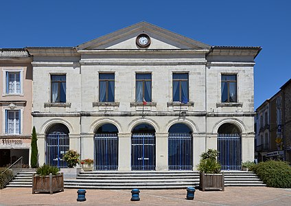 The town hall of Nontron
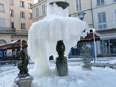 Fountain on Place Alfred Agard in winter
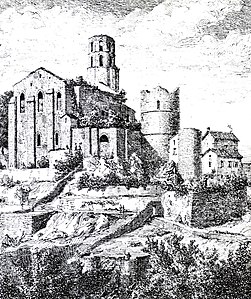 Former church and remains of the Château de Nontron around 1822
 Newer round tower on the foundations of the old fortress
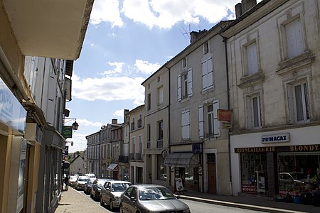 Rue Carnot
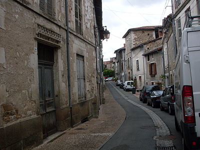 Rue Picaud
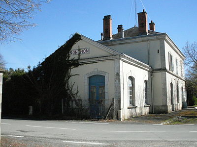 Former train station
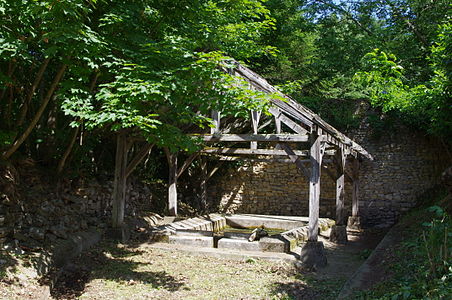 The old Nontron lavoir
 Nontrons old town from the west, winter shot


.jpg)


literature
- Dominique Beaudry, Serge la Barbera, Michel Mange and Daniel Marcadet (eds.): Cahiers de Doléances du Nontronnais. Projet d'action éducative. Lycée Alcide Dusolier, Nontron 1989, ISBN 2-906379-19-0 .
- J.-P. Floc'h u. a .: Feuille Nontron . In: Carte géologique de la France à 1/50000 . BRGM.
- Jacques Lagrange (ed.): Nontron & le Pays Nontronnais. 2 volumes. Éditions Pilote 24, Périgueux 1996, ISBN 2-9509149-1-8 . ("Quinze enfants du pays, parmi les plus titrés, ont livré leurs dernières études sur les différents aspects de leur terre").
- Hervé Lapouge: Les Maires de Nontron ou Deux Siècles de vie municipale. Préface de Frédéric de Saint-Sernin . Deltaconcept, Nontron 2005, ISBN 2-9520843-7-8 .
- Ribault de Laugardière: Monograph de la ville et du canton de Nontron (Dordogne). E. Laporte, Périgueux 1888. (New edition. Laffitte, Marseille 1979).
- G. Le Pochat et al .: Montbron . In: Carte géologique de la France at 1/50 000 . BRGM, 1986.
- Les minéraux de Nontron (Dordogne) In: Le Règne Minéral. No. 84, Novembre / Décembre 2008, ISSN 1259-4415 .
- Périgord, Quercy (= Le guide vert. 20). Michelin Éditions du Voyage, Paris 2000, ISBN 2-06-037005-1 .
- Dominique Richard (Ed.): Le Guide Dordogne-Périgord . Fanlac, Périgueux 1993, ISBN 2-86577-162-8 .