Saint-Priest-les-Fougères
|
Saint-Priest-les-Fougères Sent Prich las Fougieras |
||
|---|---|---|
|
|
||
| region | Nouvelle-Aquitaine | |
| Department | Dordogne | |
| Arrondissement | Nontron | |
| Canton | Thiviers | |
| Community association | Périgord-Limousin | |
| Coordinates | 45 ° 33 ' N , 1 ° 1' E | |
| height | 248-411 m | |
| surface | 20.86 km 2 | |
| Residents | 381 (January 1, 2017) | |
| Population density | 18 inhabitants / km 2 | |
| Post Code | 24450 | |
| INSEE code | 24489 | |
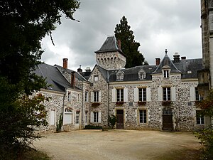
 Château d'Oche |
||
Saint-Priest-les-Fougères ( Occitan Sent Prich las Fougieras ) is a French commune with 381 inhabitants (as of January 1, 2017) in the northeast of the Dordogne department , Aquitaine region . It is an integral part of the Périgord-Limousin Regional Nature Park .
geography
Saint-Priest-les-Fougères is three kilometers east of La Coquille and 12 kilometers south-southeast of Châlus (as the crow flies). The municipality is border municipality to the Haute-Vienne department . It is surrounded by the following neighboring communities:
- Saint-Pierre-de-Frugie in the north
- Bussière-Galant (Haute-Vienne) in the northeast
- Ladignac-le-Long (Haute-Vienne) to the east (point of contact)
- Jumilhac-le-Grand to the east, southeast and south
- Saint-Paul-la-Roche in the southwest
- La Coquille to the west and northwest
In addition to the town center, the community consists of the following hamlets, farmsteads, mills and a castle: Bourdoux , Champelot , Chantalouette , Château d'Oche , Ciarlet , Coutancie , Dienne , Gué des Billes , Hièras , La Bastide , La Bessoulie , La Bourdeille , La Brégère , Labey , Le Boucheron , Le Bourg , Le Fraisse , Le Moulin de Ribeyreix , Le Moulin du Boucheron , Le Moulin Neuf , Le Petit Bost , Le Petit Moulin , Le Repaire , Les Champs Jaurès , Logebrenaud , Mas d'Arneix , Oche , Pré du Rieu , Puyssibot , Ribeyreix , Sireyjol , Tirepierre and Tour Bel-Air .
The eastern part of the municipality of Saint-Priest-les-Fougères is crossed by the Périgord , which, coming from the Forêt de Vieillecour , initially flows in a south-westerly direction, but then turns to the south. The western border of the municipality is formed by the Valouse , which also flows in a south-westerly direction. The southern section is drained by the Rochille and its tributaries, a left tributary of the Valouse.
The topographically lowest point in the municipality with 248 meters is located on the southern border southeast of Oche ; here the Périgord leaves the municipality to the southeast. The highest point at 411 meters is in the extreme north near Sireyjol on the border with Saint-Nicolas-de-Courbefy (Bussière-Galant municipality) in the Forêt de Vieillecour .
geology
The municipality of Saint-Priest-les-Fougères lies entirely on the metamorphic basement of the north-western Massif Central . The surrounding rocks form part of the lower gneiss cover , it is mainly paragneiss , mica-schistige paragneiss and fine-grained leptynites . The paragneiss is likely to have emerged from late Neoproterozoic Grauwacken and more clayey parent rocks. The granitic leptynites are assigned to the Ordovician .
The basement rocks on the ridges between the rivers are mostly covered by Pleistocene alterites , usually colluvium of fluvial origin. At Tour Bel-Air in the south there are also river sediments that may go back to the Pliocene . The gravel consists of up to 30 cm large quartz pebbles, embedded in a sand matrix.
The metamorphic rocks have reached the staurolite zone everywhere , but can also be more metamorphic ( thistle and sillimanite zone ), especially in the north of the municipality with approach to the Saint-Nicolas-Courbefy granite (municipality of Saint-Pierre-de-Frugie).
The west of the parish on the Valouse is still affected by the northeast trending La Coquille Fault , with which a bending of the regional foliation in the same direction is associated. In addition, a little further to the east, a parallel, anticlinal ridge was formed, in the core of which the mica-schistigen paragneiss are present.
history
The oldest building in Saint-Priest-les-Fougères is the local Romanesque church. The Château d'Oche dates back to the 15th century.
Population development
| year | 1962 | 1968 | 1975 | 1982 | 1990 | 1999 | 2007 | 2016 |
| Residents | 592 | 538 | 508 | 485 | 443 | 412 | 392 | 380 |
| Sources: Cassini and INSEE | ||||||||
Attractions
- Romanesque local church, which was structurally heavily modified in the 17th century (it received, among other things, its octagonal church tower in the Limousin style)
- Château d'Oche with remains from the 15th century was rebuilt in the 19th century
- Manoir de la Bastide (manor)
Transport links
Coming from the west of La Coquille, the D 79 crosses through Saint-Priest-les-Fougères; it leads to Jumilhac-le-Grand in the southeast. The town is connected to the N 21 via the D 79, the main traffic axis from Limoges to Périgueux . The place also has a connection to Saint-Pierre-de-Frugie in the north-west, to Ladignac-le-Long in the north-east and to Chalais in the south-west via municipal roads .
literature
- Briand, B. et al .: Feuille Châlus . In: Carte géologique de la France à 1/50000 . BRGM.
- Guillot, P.-L. et al .: Feuille Thiviers . In: Carte géologique de la France à 1/50000 . BRGM.
- Dominique Richard (Ed.): Le Guide Dordogne-Périgord. Fanlac, Périgueux 1993, ISBN 2-86577-162-8 .
