
Teyjat
|
Teyjat Taijac |
||
|---|---|---|
|
||
| region | Nouvelle-Aquitaine | |
| Department | Dordogne | |
| Arrondissement | Nontron | |
| Canton | Périgord Vert Nontronnais | |
| Community association | Périgord Nontronnais | |
| Coordinates | 45 ° 35 ′ N , 0 ° 35 ′ E | |
| height | 120-247 m | |
| surface | 16.99 km 2 | |
| Residents | 275 (January 1, 2017) | |
| Population density | 16 inhabitants / km 2 | |
| Post Code | 24300 | |
| INSEE code | 24548 | |
 Town center of Teyjat with the Saint-Pierre-ès-Liens church |
||

Teyjat ( Occitan Taijac ) is a commune of 275 inhabitants (at January 1, 2017) in the Dordogne in the region Nouvelle-Aquitaine . It belongs to the canton of Périgord Vert Nontronnais (until 2014: Nontron ). The responsible community association is the Communauté de communes du Périgord Nontronnais . The residents are known as Teyjatois or Teyjatoises .
geography
The area of the municipality ( French commune ) Teyjat is surrounded by the following six neighboring municipalities:
| Varaignes | Soudat | Bussière-Badil (point of contact) |
| Varaignes |
.svg)
|
Etouars |
| Javerlhac-et-la-Chapelle-Saint-Robert | Javerlhac-et-la-Chapelle-Saint-Robert | Le Bourdeix |
The municipality includes the hamlets, homesteads, brickworks and landmarks: Barancourt, Beaumont, Bellevue, Bois de Braugnac, Boisbernard, Boisseuil, Bouère, Braugnac, Caillaud, Chauffour, Chez Gourjout, Chez le Mège, La Forgeneuve, Grotte de la Borie Mairie, La Forgeneuve , La Maurendie, La Rondée, La Villa, Laudonie, Lauterie, Le Bouchage, Le Châtelard, Le Claud des Landes, Le Forestier, Le Forestier Haut, Les Brandeaux, Les Grenouilles, Les Penauds, Les Planes, Malibas, Pierre Plate, Pisse -Roussine, Quillac, Terre Nègre and Vaubrunet .
The topographical lowest point of the municipality with 120 meters above sea level is just before the confluence of the Marcourive in the Bandiat on the western edge, the highest point with 247 meters on the eastern edge north of the Bellevue brickworks on the D 93. The maximum height difference is 127 meters.
Transport links

The center of the municipality is connected by a road to the D 75 from Nontron to Marthon , which runs a little further to the west , and is about 3.5 kilometers from the main road. Via three other roads there are connections to the D 93 passing in the south from Javerlhac to Étouars and then to Piégut-Pluviers . The D 92 in the north from Mainzac and La Chapelle-Saint-Robert to Piégut-Pluviers can also be reached by road.
By the municipality Teyjat crossed once at La Villa the railway Queroy-Pranzac-Thiviers .
Hydrography
The municipality is traversed centrally by the Marcourive in a south-westerly direction, a right tributary of the Bandiat . On its north side it is bounded by the Ruisseau de l'Étang d'Assat (also known as le Crochet ) and on its south side by the Merlancon - both also right tributaries of the Bandiat, which drain roughly parallel to the Marcourive.
geology

In the north and east, the municipality touches rocks of the Variscan basement of the northwestern Massif Central . So the cuts Ruisseau de l'Etang d'Assat in its upper reaches metatexitische paragneisses ( Mζ 1-2 ) and the Marcourive placed in its upper reaches the Piégut-Pluviers granodiorite only - its fine-grained Marginal Facies in Bouère ( f γ 3M ) followed by the medium to coarse-grained normal facies ( γ 3M ) further in the upper reaches.
To the basement rocks transgredierten downstream the Liassedimente the northeastern the Aquitaine Basin - feldspathic , coarse sand stones of Hettangiums (Basistransgression), followed by arkose and dyed red, cryptocrystalline Dolomite (Formation L1-4 ). The sinemurium is absent. Transgressive sediments from the Pliensbachian , Toarcian and Aalenian are again deposited over the hettangian - mainly claystones and gray marls with detritic inclusions (formation l5-9 ). The clay stones provide the raw material for brickworks (now closed) on the eastern edge of the municipality.
This is followed by sediments of the Great Dane , which in terms of area take up the largest part. They are mostly in a recrystallized state (formation jC ) - for example in the town center as rosette facies (radial calcite crystals ) bound to faults . Occasionally, unchanged sediments can also be seen - Middle and Upper Bajocium near le Forestier , consisting of gray and white oolite limestone (formations j1b and j1c ).
On the ridges between the river valleys, the flat Mesozoic sediments are covered by loose colluvial sediments from the Pleistocene (formation HC ) and two tertiary tongues (with rounded river scree) (ridges along the D 92 north of Braugnac and Malibas and ridges from Chauffour along the D 93 - Formation HF ). The river valleys are filled with Holocene alluvium (brick-red clays with rubble of quartz, quartzite, granodiorite and limestone) (formation Fy-z ).
On the western edge of the municipality in Baran Court the northwest-southeast trending moves fault zone Javerlhac-Varaignes by which with sphalerite , galena , pyrite and barite mineralized is. It should be an expression of the right shoulder of the trough of the bandi trench . Its course in the south of the Caribbean (southeast) is also marked by a natural spring ( Fontaine de Sainte-Marguerite ). The basement was raised against the basin sediments. Smaller north-east to east-north-east trending transverse fractures are associated.
Between 1825 and 1850, manganese ore ( pyrolusite , manganite and psilomelan ) accompanied by iron and barium oxides was mined west of La Rondée in the Kolluvium . The mineralization (with a mineralization grade of 45 percent) was located in thin clay layers at the base of the Sidérolithique , which are supported by Hettangic arcoses. Several thousand tons of ore were mined.
ecology

Natural park
The municipality of Teyjat is an integral part of the Périgord-Limousin Regional Nature Park .
Protected areas
The valleys of the Ruisseau de l'Étang d'Assat and the Marcourive - both right tributaries of the Bandiat, are under nature protection . These areas are designated as ZNIEFF (French zone naturelle d'intérêt écologique, faunistique et floristique ) of type 1 under the name Vallées du réseau hydrographique du Bandiat . Its flora consists of more than 100 plant species with large ormennig ( Agrimonia procera ) and Atlantic hare bells ( Hyacinthoides non-scripta ) as indicator plants.
history
The prehistoric presence of man is clearly documented by the Teyjat cave , in which there are around 40 incised drawings from the late Magdalenian period (around 10,000 BC). Horned bearers such as bison, cattle, reindeer and deer are depicted . Nearby is the Abri Mège , which was probably settled very early. On a hill near Vaubrunet there are (the very sparse) remains of a dolmen ( Pierre Plate ) from the megalithic period , made of granodiorite and paragneiss.
The local church of Saint-Pierre-ès-Liens dates back to the 12th century.
Population development
| Population development in Teyjat | ||||
|---|---|---|---|---|
| year | Residents |

|
||
| 1962 | 379 | |||
| 1968 | 363 | |||
| 1975 | 372 | |||
| 1982 | 364 | |||
| 1990 | 309 | |||
| 1999 | 320 | |||
| 2004 | 278 | |||
| 2007 | 269 | |||
| 2009 | 272 | |||
| 2014 | 278 | |||
| 2016 | 275 | |||
| 2017 | 275 | |||
Source: INSEE
The population figures are generally declining, with particularly sharp drops after 1982 and 1999.
With an area of 16.99 square kilometers, Teyjat has a relatively low population density of 16 inhabitants / km².
mayor
Mayor of Teyjat has been the Divers gauche pensioner Jean-Pierre Garraud since March 1989 .
Karting facility
A karting facility is located south of the hamlets of Beaumont and Laudonie .
Attractions
- Teyjat cave (French: Grotte dite de la Mairie )
- Church Saint-Pierre-ès-Liens from the 12th century, has been structurally changed in the 16th and 19th centuries, Monument historique since 2019
- Manoir du Forestier , 17th and 18th centuries
- Manoir du Chatelard , 17th and 19th centuries
- Manoir de Brognac , built from 1871.
Photo gallery
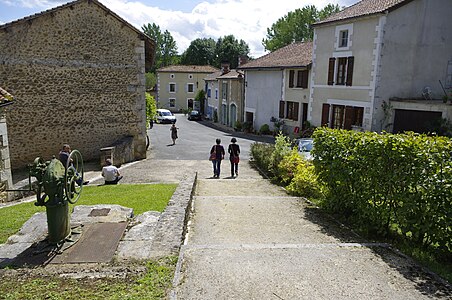 View from the cave museum to the south into the town center
 Saint-Pierre-ès-Liens church portal
 Baptismal font
 Mairie
 Manoir de Chatelard Castle
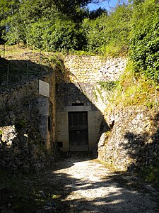 The Teyjat cave


Individual evidence
- ^ Occitan name of the parishes in Périgord, website of the Conseil général de la Dordogne
- ^ Teyjat on the Insee website
literature
- G. Le Pochat et al. a .: Feuille Montbron . In: Carte géologique de la France at 1/50 000 . BRGM, 1986.