
Saint-Sulpice-d'Excideuil
|
Saint-Sulpice-d'Excideuil Sent Soplesís d'Eissiduelh |
||
|---|---|---|
|
||
| region | Nouvelle-Aquitaine | |
| Department | Dordogne | |
| Arrondissement | Nontron | |
| Canton | Isle-Loue-Auvézère | |
| Community association | Isle-Loue-Auvézère en Périgord | |
| Coordinates | 45 ° 23 ′ N , 1 ° 0 ′ E | |
| height | 159-327 m | |
| surface | 19.72 km 2 | |
| Residents | 344 (January 1, 2017) | |
| Population density | 17 inhabitants / km 2 | |
| Post Code | 24270 | |
| INSEE code | 24505 | |
 View of Saint-Sulpice-d'Excideuil |
||

Saint-Sulpice-d'Excideuil ( Occitan : Sent Soplesís d'Eissiduelh ) is a commune with 344 inhabitants (as of January 1, 2017) in the French Dordogne in the Nouvelle-Aquitaine region . The municipality belongs to the Arrondissement of Nontron and the canton of Isle-Loue-Auvézère (until 2015: canton of Lanouaille ). The inhabitants are called Saint-Sulpiçois .
geography
Saint-Sulpice-d'Excideuil is located about 48 kilometers northeast of Périgueux . Saint-Sulpice-d'Excideuil is surrounded by the neighboring communities of Sarrazac in the north, Dussac in the east and south-east, Clermont-d'Excideuil in the south-east, Saint-Germain-des-Prés in the south, Saint-Jory-las-Bloux in the south-west, Corgnac-sur-l'Isle to the west and south-west and Nanthiat to the west and north-west.
Population development
| 1962 | 1968 | 1975 | 1982 | 1990 | 1999 | 2006 | 2013 |
|---|---|---|---|---|---|---|---|
| 656 | 591 | 491 | 432 | 406 | 355 | 328 | 313 |
| Source: Cassini and INSEE | |||||||
Attractions
- Saint-Césaire church from the 12th century, a historic monument since 1974
- Manor house of Igonie from the 15th / 16th centuries Century, Monument historique since 1965
- Premilhac Castle
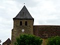
Saint-Césaire church

Igonie manor house

