
Le Bourdeix
| Le Bourdeix | ||
|---|---|---|
|
||
| region | Nouvelle-Aquitaine | |
| Department | Dordogne | |
| Arrondissement | Nontron | |
| Canton | Périgord Vert Nontronnais | |
| Community association | Périgord Nontronnais | |
| Coordinates | 45 ° 35 ' N , 0 ° 38' E | |
| height | 141-275 m | |
| surface | 11.69 km 2 | |
| Residents | 226 (January 1, 2017) | |
| Population density | 19 inhabitants / km 2 | |
| Post Code | 24300 | |
| INSEE code | 24056 | |
 Church and Mairie of Le Bourdeix |
||

Le Bourdeix , Occitan Lu Bordelh or Lu Borg Dei , is a French municipality with 226 inhabitants (at January 1, 2017) in the Dordogne in the region Nouvelle-Aquitaine (before 2016 Aquitaine ). It belongs to the Arrondissement of Nontron and the canton of Périgord Vert Nontronnais (until 2015 Nontron ). The responsible community association is the Communauté de communes du Périgord Nontronnais . The inhabitants are called Bourdeixois or Bourdeixoises .
etymology
The Occitan Lu Borg Dei probably emerged from Lu Borg d'Aún , which in turn is likely to be derived from the Gallic Burgus Agedunus .
geography
Le Bourdeix is about ten kilometers from the south-southeast of Nontron and about seven kilometers from Piégut-Pluviers in the northeast.
Le Bourdeix is surrounded by the following seven neighboring municipalities:
| Etouars | Saint-Estèphe | |
| Teyjat |
.svg)
|
Augignac |
| Javerlhac-et-la-Chapelle-Saint-Robert | Saint-Martin-le-Pin | Nontron |
The municipal area of Le Bourdeix includes the following hamlets, farmsteads, a former blacksmith's forge, a brickworks and landmarks: Bonnefont , Bouchardières , Chaffrelière , Chez Carrier , Combas , La Bosse , La Chapoulie , La Grange , La Renardière , Le Claud , Le Débat , Le Doyer , Le Dubreuil , Le Moulin Rou , Le Petit Pys , Le Pont de Lavaud , Le Prieuré , Les Forges , Les Grenouilles , Les Queyroux , Moulin de Pinard , Pay Blanc , Plaisance , Puydivert , Rapy , Rouméjoux and Serpine .
The topographically lowest point of the municipality is 141 meters above sea level on the Doue in the extreme southwest, the highest point at 275 meters at Puydivert in the northeast. The absolute height difference is 134 meters. The town center is located at 226 meters above sea level.
Transport links

Le Bourdeix is on the D 3 from Nontron to Bussière-Badil . Piégut-Pluviers can be reached via the D 91 E3 branching off to the northeast . A communal road going east from the town center leads to neighboring Saint-Estèphe. Another municipal road goes south, crosses the Doue valley and then forks towards Saint-Martin-le-Pin and Nontron. There is also a connection to the west in the direction of the D 93 with a connection to Javerlhac or via Étouars to Piégut-Pluviers.
Hydrography
The municipality is divided into two halves by the Doue. The Doue comes over from Saint-Estèphe and initially flows in a west-east direction. To the south-west of the town center, it takes up the Ruisseau des Forges as a right branch and then turns to the south-west. The southern border of the municipality with Saint-Martin-le-Pin forms the Combas, which flows in the WNW direction, a small left side stream of the Doue.
geology

The community of Le Bourdeix is largely located on the Piégut-Pluviers-Granodiorit in its coarse-grained normal facies ( γ 3M ). Only in the western section (on the ridge west of the Ruisseau des Forges and Doue) transgredieren flat-lying Liassedimente the northeast the Aquitaine Basin - arkose of Hettangiums (Formation L1-4 ) and mudstones of Toarciums (Formation l5-9 ) over the granodiorite. The ridge north of the Combas (between Le Prieuré and La Chapoulie ) is also occupied by the Lias. The claystones of the Toarcium were formerly mined near Les Grenouilles as raw material for the now disused brickworks.
To the west of the hamlet of Bouchardières crosses a north-northwest trending fault ; the Liass sediments in the west have been lowered on it opposite the granodiorite. Another disturbance passes the hamlet of Combas in an east-northeast direction.
The Liass sediments of the southern ridge are masked in two places by the Pleistocene colluvium of the HC formation (near Les Queyroux and Le Moulin Rou ) - sandy-clay gravels with quartz pebbles .
The granodiorite shows mineralization on barite at Combas and Moulin de Pinard as well as galena at Moulin de Pinard .
ecology
Le Bourdeix is an integral part of the Périgord-Limousin Regional Natural Park .
history

The oldest preserved buildings in Le Bourdeix are the donjon , built from granodiorite ashlars, from the 11th century and the Romanesque church of Saint-Pierre et Saint-Paul from the 12th century, also in granodiorite. The donjon is the only remnant of the former fortified castles of Le Bourdeix, the first of which was destroyed by the English during the Hundred Years War in the reign of Charles VII around 1450 . In the 15th century a second fortified castle was built 50 meters further, in the 17th century a third followed near the church. Both of these fortified castles were still preserved in the 18th century.
The original Romanesque church was extended in 1480 by a second aisle built on the south side and now forms a rectangular hall church measuring 21 × 6 meters. The Romanesque ceiling part is supported by round arches, but the extension is supported by pointed arches. In the former smithy Les Forges , through which the border to neighboring Étouars runs, iron ore from the Nontronnais was melted in blast furnaces ( cast iron ) and processed into cannons for the French Navy in Rochefort between the 15th and 18th centuries . The forge was powered by water power, so the Ruisseau des Forges was dammed into a pond for this purpose .
Population development
| Population development in Le Bourdeix | ||||
|---|---|---|---|---|
| year | Residents | Population density |

|
|
| 1962 | 296 | 25 / km² | ||
| 1968 | 254 | 22 / km² | ||
| 1975 | 207 | 18 / km² | ||
| 1982 | 212 | 18 / km² | ||
| 1990 | 230 | 20 / km² | ||
| 1999 | 229 | 20 / km² | ||
| 2006 | 251 | 22 / km² | ||
| 2007 | 254 | 22 / km² | ||
| 2008 | 260 | 22 / km² | ||
| 2012 | 240 | 20 / km² | ||
| 2013 | 239 | 20 / km² | ||
| 2015 | 234 | 20 / km² | ||
| 2017 | 226 | 19 / km² | ||
Source: INSEE
The population had suffered severe losses in the 1960s, but had been growing steadily again since 1975 and then declined again from 2008.
mayor
Mayor has been Alain Lapeyronnie, a craftsman since March 2001, who represents Debout la France .
Economy and Infrastructure
employment
In 2012, the employed population aged between 15 and 64 was 100, which is 41.7% of the total population. 88 of them were employed and 12 were registered as unemployed. Compared to September 2007, the number of unemployed has increased, the unemployment rate is now 12.0%.
Companies
As of December 31, 2013 there were 26 companies in the municipality, 14 of them in trade, transport and services, 7 in industry, 2 in construction, 2 in the administration, teaching, health and social sectors and one in the agriculture, forestry and fishing sectors .
Attractions
Worth seeing in Le Bourdeix are:
- The 20 meter high donjon from the 11th century, since 1988 Monument Historique .
- The 12th century church of Saint-Pierre et Saint-Paul
- An old pigeon tower
- The Moulin de Pinard mill in which flour was ground and walnut oil was produced
- The smithy Les Forges d'Étouars .
The church of Le Bourdeix, which was heavily modified in the 15th century and around 1600, is known for its amazing frescoes . Depicted are the deceased with pale faces, wrapped in black robes. The images from the 15th - 16th centuries are said to have had a symbolic defense against the plague and other epidemics.
Photo gallery

The keep of Le Bourdeix
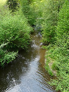
The Doue downstream from Ligneras

Town Hall (Mairie)

Entrance portal of Saint-Pierre et Saint-Paul

Romanesque nave
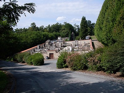
graveyard

Pinard mill drive shaft


literature
- G. Le Pochat and others: Feuille Montbron . In: Carte géologique de la France à 1/50 000. BRGM, 1986.
Web links
- Website with Occitan place names in the Dordogne department
- Le Bourdeix on the annuaire-mairie.fr website
- Le Bourdeix on cartesfrance.fr in French
- Population development since 1793 on cassini.ehess.fr